File:Global Digital Elevation Model.jpg

Original file (4,320 × 2,160 pixels, file size: 1.08 MB, MIME type: image/jpeg)
Captions
Captions
Summary[edit]
| Description |
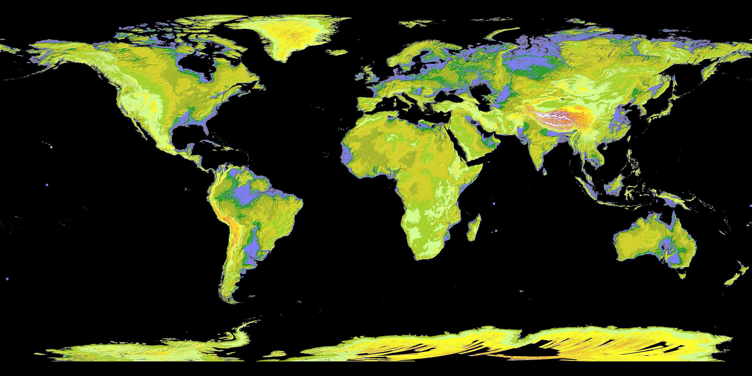
English: Global Digital Elevation Model
This Global Digital Elevation Model, or GDEM, is a product of the Advanced Spaceborne Thermal Emission and Reflection Radiometer (ASTER), a joint program of NASA and Japan's Ministry of Economy, Trade and Industry. The image was released on 29 June 2009, and was created by processing and stereo-correlating the 1.3 million-scene ASTER archive of optical images, covering Earth's land surface between 83 degrees North and 83 degrees South latitudes. The GDEM is produced with 29 m postings, and is formatted as 23,000 one-by-one-degree tiles. In this coloured version, low elevations are purple, medium elevations are greens and yellows, and high elevations are orange, red and white. With its 14 spectral bands from the visible to the thermal infrared wavelength region and its high spatial resolution of 15 to 100 m, ASTER images Earth to map and monitor the changing surface of our planet. ASTER is one of five Earth-observing instruments launched 18 Dec. 1999, on NASA's Terra satellite. The broad spectral coverage and high spectral resolution of ASTER provides scientists in numerous disciplines with critical information for surface mapping and monitoring of dynamic conditions and temporal change. Image Credit: NASA/GSFC/METI/ERSDAC/JAROS, and U.S./Japan ASTER Science Team |
| Date | |
| Source | http://www.nasa.gov/images/content/412091main_PIA12090_full.jpg |
| Author | Nasa.gov http://www.nasa.gov/topics/earth/earthday/earthday_gallery.html |
This image or video was catalogued by Goddard Space Flight Center of the United States National Aeronautics and Space Administration (NASA) under Photo ID: PIA12090. This tag does not indicate the copyright status of the attached work. A normal copyright tag is still required. See Commons:Licensing. Other languages:
|
Licensing[edit]
| This file is in the public domain in the United States because it was solely created by NASA. NASA copyright policy states that "NASA material is not protected by copyright unless noted". (See Template:PD-USGov, NASA copyright policy page or JPL Image Use Policy.) | ||
 |
Warnings:
|
File history
Click on a date/time to view the file as it appeared at that time.
| Date/Time | Thumbnail | Dimensions | User | Comment | |
|---|---|---|---|---|---|
| current | 20:22, 17 April 2010 | | 4,320 × 2,160 (1.08 MB) | LuisArmandoRasteletti (talk | contribs) | {{Information |Description={{en|1=Global Digital Elevation Model}} |Source=http://www.nasa.gov/images/content/412091main_PIA12090_full.jpg |Author=Nasa.gov |Date=17 de abril de 2010 |Permission= |other_versions= }} Category:NASA |
You cannot overwrite this file.
File usage on Commons
The following 2 pages use this file:
File usage on other wikis
The following other wikis use this file:
- Usage on ast.wikipedia.org
- Usage on es.wikipedia.org
- Usage on ja.wikipedia.org