File:Grey Iron Flow Diagram c. 1947 - Stockham Pipe and Fittings Company, 4000 Tenth Avenue North, Birmingham, Jefferson County, AL HAER ALA,37-BIRM,45- (sheet 5 of 9).tif
Jump to navigation
Jump to search

Size of this JPG preview of this TIF file: 776 × 600 pixels. Other resolutions: 311 × 240 pixels | 621 × 480 pixels | 994 × 768 pixels | 1,280 × 989 pixels | 2,560 × 1,978 pixels | 17,642 × 13,632 pixels.
Original file (17,642 × 13,632 pixels, file size: 1.84 MB, MIME type: image/tiff)
Captions
Captions
Add a one-line explanation of what this file represents
Summary[edit]
| Warning | The original file is very high-resolution. It might not load properly or could cause your browser to freeze when opened at full size. |
|---|
| Grey Iron Flow Diagram c. 1947 - Stockham Pipe and Fittings Company, 4000 Tenth Avenue North, Birmingham, Jefferson County, AL | ||||
|---|---|---|---|---|
| Photographer |
Peterson, Kristin Related names:
|
|||
| Title |
Grey Iron Flow Diagram c. 1947 - Stockham Pipe and Fittings Company, 4000 Tenth Avenue North, Birmingham, Jefferson County, AL |
|||
| Depicted place | Alabama; Jefferson County; Birmingham | |||
| Date | 1994 | |||
| Dimensions | 34 x 44 in. (E size) | |||
| Current location |
Library of Congress Prints and Photographs Division Washington, D.C. 20540 USA http://hdl.loc.gov/loc.pnp/pp.print |
|||
| Accession number |
HAER ALA,37-BIRM,45- (sheet 5 of 9) |
|||
| Credit line |
|
|||
| Notes |
|
|||
| Source | https://www.loc.gov/pictures/item/al1054.sheet.00005a | |||
| Permission (Reusing this file) |
|
|||
| Other versions |
.png) .png) .png) .png) .png) .png) .png) .png) .png) |
|||

| Object location | | View this and other nearby images on: OpenStreetMap |
|---|
File history
Click on a date/time to view the file as it appeared at that time.
| Date/Time | Thumbnail | Dimensions | User | Comment | |
|---|---|---|---|---|---|
| current | 22:57, 30 June 2014 | 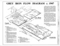 | 17,642 × 13,632 (1.84 MB) | Fæ (talk | contribs) | GWToolset: Creating mediafile for Fæ. HABS batch upload 29 June 2014 (101:150) |
You cannot overwrite this file.
File usage on Commons
The following page uses this file: