File:Interior view showing spanish stove in kitchen, southeast corner of dwelling - Faro de Punta de Las Figuras, Punta de las Figuras, Las Palmas, Arroyo Municipio, PR HAER PR,16-PALM,1-10.tif
Jump to navigation
Jump to search
Size of this JPG preview of this TIF file: 477 × 599 pixels. Other resolutions: 191 × 240 pixels | 382 × 480 pixels | 611 × 768 pixels | 815 × 1,024 pixels | 1,630 × 2,048 pixels | 3,980 × 5,000 pixels.
Original file (3,980 × 5,000 pixels, file size: 18.98 MB, MIME type: image/tiff)
Captions
Captions
Add a one-line explanation of what this file represents
Summary[edit]
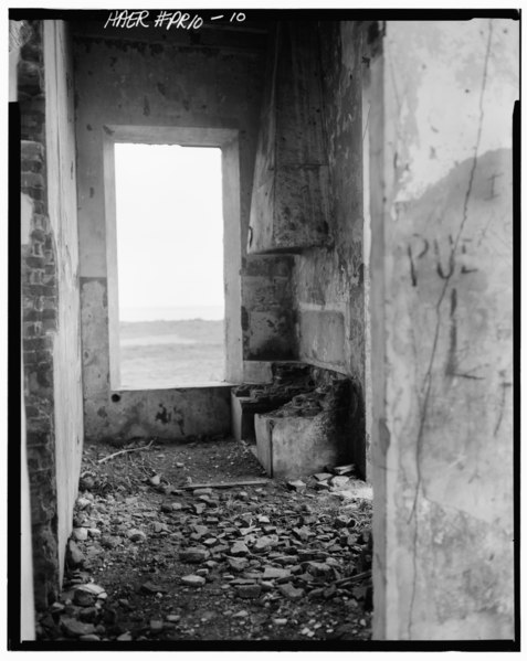
| Interior view showing spanish stove in kitchen, southeast corner of dwelling - Faro de Punta de Las Figuras, Punta de las Figuras, Las Palmas, Arroyo Municipio, PR | ||||
|---|---|---|---|---|
| Photographer |
Morales, Luis, creator |
|||
| Title |
Interior view showing spanish stove in kitchen, southeast corner of dwelling - Faro de Punta de Las Figuras, Punta de las Figuras, Las Palmas, Arroyo Municipio, PR |
|||
| Description |
U.S. Department of Commerce; Central Lighthouse Commission; Barbier, Bernard, Cie; Murphy, Kevin, transmitter; Morales, Luis, photographer; Nistal-Moret, Benjamin, historian |
|||
| Depicted place | Puerto Rico; Arroyo Municipio; Las Palmas | |||
| Date | 1978 | |||
| Dimensions | 4 x 5 in. | |||
| Current location |
Library of Congress Prints and Photographs Division Washington, D.C. 20540 USA http://hdl.loc.gov/loc.pnp/pp.print |
|||
| Accession number |
HAER PR,16-PALM,1-10 |
|||
| Credit line |
|
|||
| Notes |
|
|||
| Source | https://www.loc.gov/pictures/item/pr0039.photos.143153p | |||
| Permission (Reusing this file) |
|
|||

File history
Click on a date/time to view the file as it appeared at that time.
| Date/Time | Thumbnail | Dimensions | User | Comment | |
|---|---|---|---|---|---|
| current | 10:15, 1 August 2014 |  | 3,980 × 5,000 (18.98 MB) | Fæ (talk | contribs) | GWToolset: Creating mediafile for Fæ. HABS 31 July 2014 (3000:3200) |
You cannot overwrite this file.
File usage on Commons
The following page uses this file: