File:Karte HafenCity-Quartier Elbbrücken.svg
Jump to navigation
Jump to search

Size of this PNG preview of this SVG file: 800 × 468 pixels. Other resolutions: 320 × 187 pixels | 640 × 375 pixels | 1,024 × 600 pixels | 1,280 × 749 pixels | 2,560 × 1,499 pixels | 1,175 × 688 pixels.
Original file (SVG file, nominally 1,175 × 688 pixels, file size: 624 KB)
Captions
Captions
Add a one-line explanation of what this file represents
Summary[edit]
| Description |
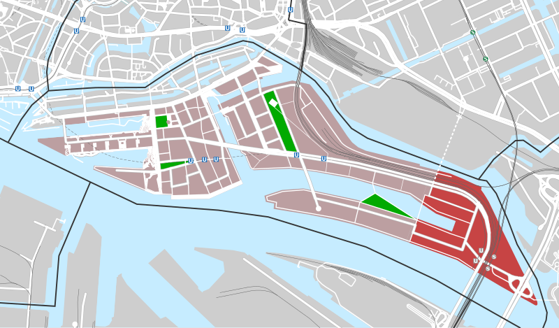
Deutsch: Quartier Elbbrücken (rot) in der HafenCity (hellrot) innerhalb des Hamburger Stadtteils HafenCity (schwarze Linie) |
| Date | |
| Source | Own work using: OpenStreetMap data |
| Author | NordNordWest |

|
This map has been made or improved in the German Kartenwerkstatt (Map Lab). You can propose maps to improve as well.
|
Licensing[edit]
| This work contains information from OpenStreetMap, which is made available under the Open Database License (ODbL).
The ODbL does not require any particular license for maps produced from ODbL data. Prior to 1 August 2020, map tiles produced by the OpenStreetMap Foundation were licensed under the CC-BY-SA-2.0 license. Maps produced by other people may be subject to other licences. |
This file is licensed under the Creative Commons Attribution-Share Alike 2.0 Generic license.
- You are free:
- to share – to copy, distribute and transmit the work
- to remix – to adapt the work
- Under the following conditions:
- attribution – You must give appropriate credit, provide a link to the license, and indicate if changes were made. You may do so in any reasonable manner, but not in any way that suggests the licensor endorses you or your use.
- share alike – If you remix, transform, or build upon the material, you must distribute your contributions under the same or compatible license as the original.
File history
Click on a date/time to view the file as it appeared at that time.
| Date/Time | Thumbnail | Dimensions | User | Comment | |
|---|---|---|---|---|---|
| current | 12:51, 13 March 2015 | | 1,175 × 688 (624 KB) | Flor!an (talk | contribs) | detaillierter + Parks + ÖPNV (inkl. aller Planungen) |
| 18:39, 27 August 2013 |  | 1,175 × 688 (516 KB) | NordNordWest (talk | contribs) | == {{int:filedesc}} == {{Information |Description= {{de|1=''Quartier Elbbrücken'' (rot) in der HafenCity (hellrot) innerhalb des Hamburger Stadtteils HafenCity (schwarze Linie)}} |Source={{Own using}} OpenStreetMap data |Date... |
You cannot overwrite this file.
File usage on Commons
The following page uses this file:
File usage on other wikis
The following other wikis use this file:
- Usage on de.wikipedia.org