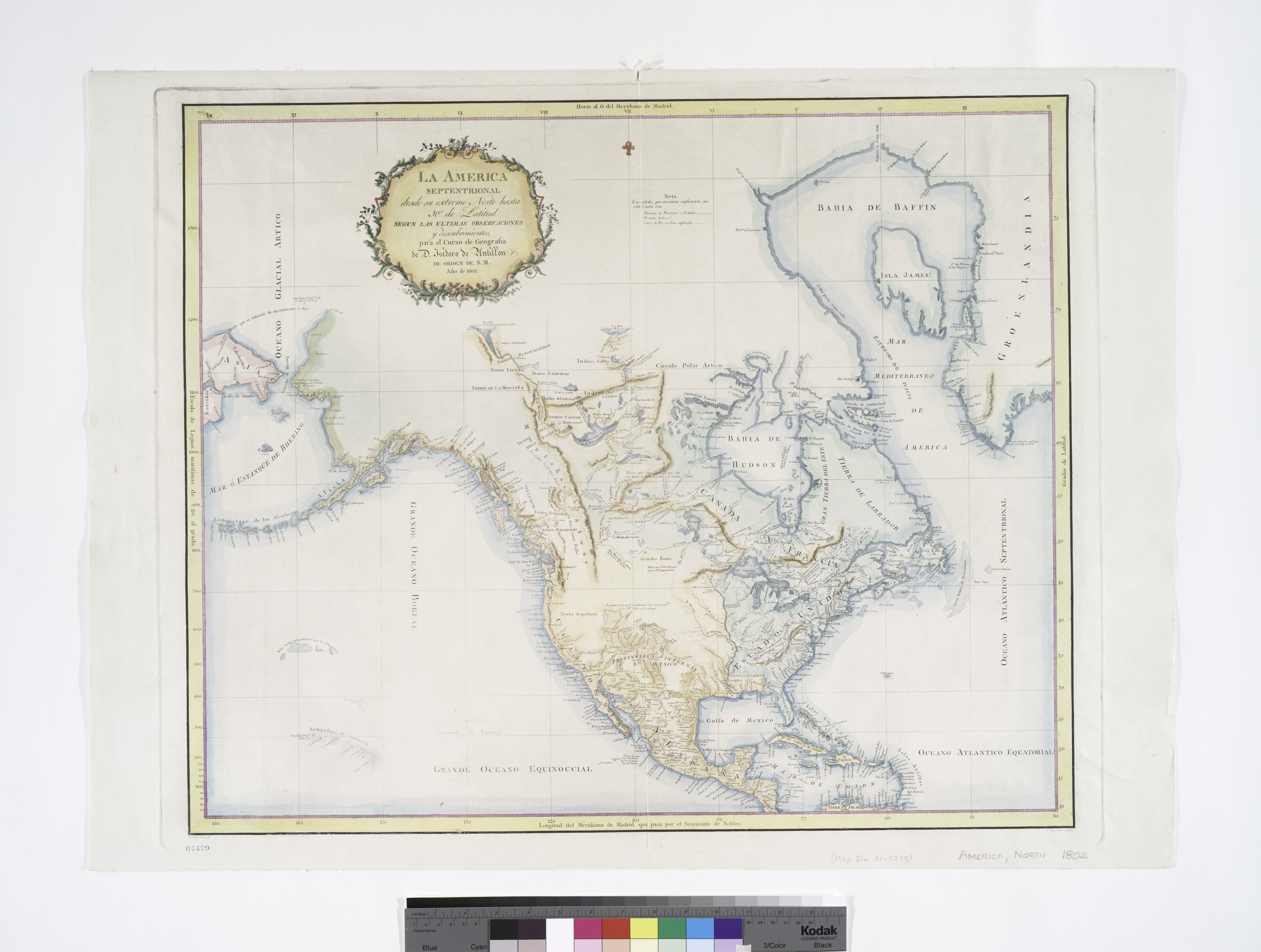
File:La America septentrional, desde su extremo norte hasta 10º de latitud - segun las ultimas observaciones y descubrimientos, para el curso de geografia de D. Isidoro de Antillon de orden de S.M., ñno NYPL434044.tiff
Jump to navigation
Jump to search

Size of this JPG preview of this TIF file: 794 × 600 pixels. Other resolutions: 318 × 240 pixels | 636 × 480 pixels | 1,017 × 768 pixels | 1,280 × 967 pixels | 2,560 × 1,934 pixels | 5,603 × 4,232 pixels.
Original file (5,603 × 4,232 pixels, file size: 67.88 MB, MIME type: image/tiff)
Captions
Captions
Add a one-line explanation of what this file represents
Summary
[edit]| Description | La America septentrional, desde su extremo norte hasta 10º de latitud / segun las ultimas observaciones y descubrimientos, para el curso de geografia de D. Isidoro de Antillon de orden de S.M., ñno de 1802 ; F. Selma la grabó ; P. Gangoiti la escribió.; Maps of North America. / Whole | |||||||||||||||||||||||
| Notes | Appears in the author's De Geographia. Madrid, 1804--Wheat. ''Note 2.'') Includes decorative cartouche and notes. ''Note 3.'') Possible 20th century re-strike from original plate? ''Note 4.'') Prime meridian: Madrid. ''Note 5.'') Relief shown pictorially and by hachures. ''Note 6.'') National Endowment for the Humanities Grant for Access to Early Maps of the Middle Atlantic Seaboard. | |||||||||||||||||||||||
| Item physical description | 1 map : hand col. ; 57 x 69 cm. | |||||||||||||||||||||||
| Catalogue call number | Map Div. 01-5239 [Filed with North America, 1802] | |||||||||||||||||||||||
| Standard reference | Phillips 4305; Wheat, C.I. Mapping the transmississippi West, I, 252 | |||||||||||||||||||||||
| Date | circa 1804 | |||||||||||||||||||||||
| Source |
http://digitalgallery.nypl.org/nypldigital/dgkeysearchdetail.cfm?imageID=434044
|
|||||||||||||||||||||||
| Author | Isidoro de, 1778-1814 -- Geographer (not in Relator list) Antillón | |||||||||||||||||||||||
| Permission (Reusing this file) |
From The Lionel Pincus and Princess Firyal Map Division. http://maps.nypl.org
|
|||||||||||||||||||||||
| Location | Stephen A. Schwarzman Building / The Lionel Pincus and Princess Firyal Map Division | |||||||||||||||||||||||
| Digital item published | 2-3-2004; updated 3-25-2011 | |||||||||||||||||||||||
| Digital ID | 434044 | |||||||||||||||||||||||

The making of this file was supported by Wikimedia UK.
To see other files made with the support of Wikimedia UK, please see the category Supported by Wikimedia UK.
|
File history
Click on a date/time to view the file as it appeared at that time.
| Date/Time | Thumbnail | Dimensions | User | Comment | |
|---|---|---|---|---|---|
| current | 15:47, 19 February 2016 |  | 5,603 × 4,232 (67.88 MB) | SteinsplitterBot (talk | contribs) | Bot: Image rotated by 270° |
| 05:06, 2 May 2014 |  | 4,232 × 5,603 (67.85 MB) | Fæ (talk | contribs) | GWToolset:: Creating mediafile for Fæ. Tranche 3 7900-11574 (restart) @ 1 May, 12:43 BST |
You cannot overwrite this file.
File usage on Commons
The following page uses this file: