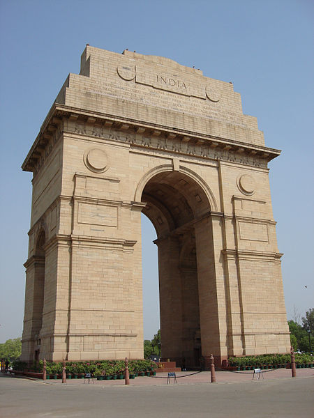
File:Lascar India Gate (New Delhi) (4499846308).jpg
From Wikimedia Commons, the free media repository
Jump to navigation
Jump to search

Size of this preview: 450 × 600 pixels. Other resolutions: 180 × 240 pixels | 360 × 480 pixels | 576 × 768 pixels | 768 × 1,024 pixels | 1,944 × 2,592 pixels.
Original file (1,944 × 2,592 pixels, file size: 1.6 MB, MIME type: image/jpeg)
File information
Structured data
Captions
Captions
Add a one-line explanation of what this file represents
Summary[edit]
| DescriptionLascar India Gate (New Delhi) (4499846308).jpg | Situated on the Rajpath in New Delhi, India Gate (originally called the All India War Memorial) is a monument built by Edwin Lutyens to commemorate the Indian soldiers who died in the World War I and the Afghan Wars. The foundation stone was laid on 10 February 1921 by the Duke of Connaught. The names of the soldiers who died in these wars are inscribed on the walls. It was completed in 1931. Burning under it since 1971 is the Amar Jawan Jyoti (The flame of the immortal warrior), which marks the Unknown Soldier's Tomb. Inscribed on top of India Gate in capital letters is the line: To the dead of the Indian armies who fell honoured in France and Flanders Mesopotamia and Persia East Africa Gallipoli and elsewhere in the near and the far-east and in sacred memory also of those whose names are recorded and who fell in India or the north-west frontier and during the Third Afgan War. The shrine itself is a black marble cenotaph with a rifle placed on its barrel, crested by a soldier's helmet. Each face of the cenotaph has inscribed in gold the words "Amar Jawan" (Immortal Warrior). This cenotaph is itself placed on an edifice which has on its four corners four flames that are perpetually kept alive. India Gate New Delhi. India Gate New Delhi. The 42 metre tall India Gate is situated such that many important roads spread out from it. Traffic passing around India Gate used to be continuous till the roads were closed to the public due to terrorist threats. The lawns around Rajpath are thronged by people during the night, when the India Gate is lit up. [Wikipedia.org] |
| Date | |
| Source | India Gate (New Delhi) |
| Author | Jorge Láscar from Australia |
| Camera location | 28° 36′ 46.31″ N, 77° 13′ 45.5″ E | View this and other nearby images on: OpenStreetMap |
|---|
Licensing[edit]
This file is licensed under the Creative Commons Attribution 2.0 Generic license.
- You are free:
- to share – to copy, distribute and transmit the work
- to remix – to adapt the work
- Under the following conditions:
- attribution – You must give appropriate credit, provide a link to the license, and indicate if changes were made. You may do so in any reasonable manner, but not in any way that suggests the licensor endorses you or your use.
| This image was originally posted to Flickr by Jorge Lascar at https://www.flickr.com/photos/8721758@N06/4499846308. It was reviewed on 2 April 2014 by FlickreviewR and was confirmed to be licensed under the terms of the cc-by-2.0. |
2 April 2014
File history
Click on a date/time to view the file as it appeared at that time.
| Date/Time | Thumbnail | Dimensions | User | Comment | |
|---|---|---|---|---|---|
| current | 09:23, 2 April 2014 |  | 1,944 × 2,592 (1.6 MB) | Russavia (talk | contribs) | Transferred from Flickr |
You cannot overwrite this file.
File usage on Commons
There are no pages that use this file.