File:Map of Hamlin County, South Dakota - compiled and drawn from a special survey and official records. LOC 2012593116.tif
Jump to navigation
Jump to search
Size of this JPG preview of this TIF file: 759 × 599 pixels. Other resolutions: 304 × 240 pixels | 608 × 480 pixels | 973 × 768 pixels | 1,280 × 1,011 pixels | 2,560 × 2,022 pixels | 8,225 × 6,495 pixels.
Original file (8,225 × 6,495 pixels, file size: 152.84 MB, MIME type: image/tiff)
Captions
Captions
Add a one-line explanation of what this file represents
Summary[edit]
| Description |
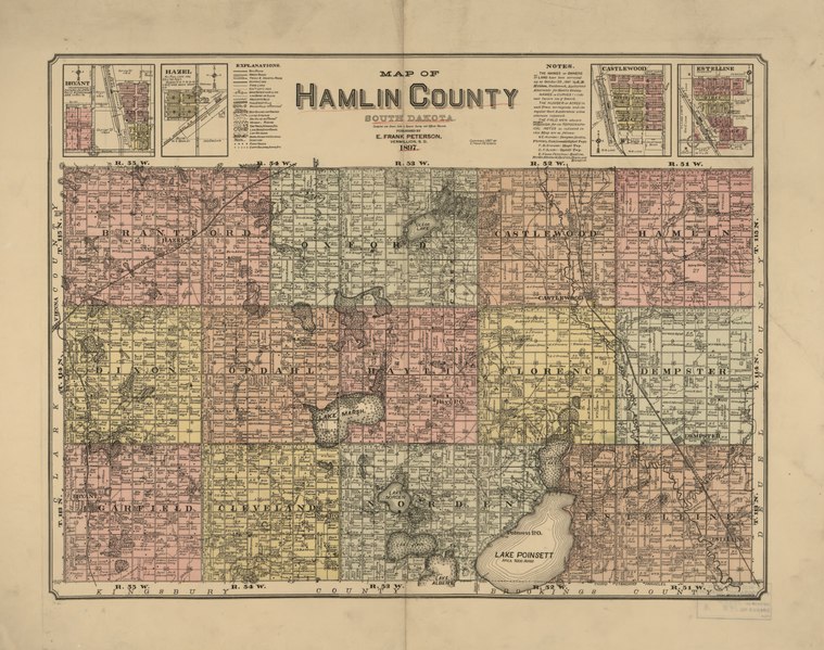
English: Relief shown by hachures. Cadastral map showing drainage, section lines and numbers, land ownership, landowners' names, roads, railroads, etc. "Copyright 1897 by E. Frank Peterson." "The names of owners of land have been corrected up to October 29, 1897." Includes notes and insets of "Bryant," "Hazel," "Castlewood," and "Estelline." LC Land ownership maps, 853 Available also through the Library of Congress Web site as a raster image. |
||
| Title | Map of Hamlin County, South Dakota : compiled and drawn from a special survey and official records. | ||
| Shelf ID | G4183.H3 1897 .P41 G4183.H3 1897 .P41 Copy 2 | ||
| Date | |||
| Source | https://www.loc.gov/item/2012593116/ | ||
| Author | Peterson, E. Frank | ||
| Permission (Reusing this file) |
|
||
| Other versions |
|
||
| Location | United States · Hamlin County · South Dakota | ||
| Part of | American Memory · Catalog · County Landownership Maps · Geography And Map Division · Cultural Landscapes | ||
| Subject | Cadastral Maps · South Dakota · United States · Maps · Hamlin County · Real Property · Landowners · Hamlin County (S.D.) |


Licensing[edit]
|
This is a faithful photographic reproduction of a two-dimensional, public domain work of art. The work of art itself is in the public domain for the following reason:
The official position taken by the Wikimedia Foundation is that "faithful reproductions of two-dimensional public domain works of art are public domain".
This photographic reproduction is therefore also considered to be in the public domain in the United States. In other jurisdictions, re-use of this content may be restricted; see Reuse of PD-Art photographs for details. | ||||
File history
Click on a date/time to view the file as it appeared at that time.
| Date/Time | Thumbnail | Dimensions | User | Comment | |
|---|---|---|---|---|---|
| current | 09:40, 20 May 2018 |  | 8,225 × 6,495 (152.84 MB) | Fæ (talk | contribs) | LOC Maps https://www.loc.gov/item/2012593116/ #164 |
You cannot overwrite this file.
File usage on Commons
The following page uses this file: