File:Map of the battle field of Carnifex Ferry, Gauley River, West Va., Sept. 10th 1861. United States forces commanded by Brig. Gen. W. S. Rosecrans LOC 99448908.tif
Jump to navigation
Jump to search

Size of this JPG preview of this TIF file: 548 × 599 pixels. Other resolutions: 219 × 240 pixels | 439 × 480 pixels | 702 × 768 pixels | 936 × 1,024 pixels | 1,872 × 2,048 pixels | 4,606 × 5,038 pixels.
Original file (4,606 × 5,038 pixels, file size: 66.39 MB, MIME type: image/tiff)
Captions
Captions
Add a one-line explanation of what this file represents
Summary[edit]
| Description |
English: Scale 1:5280. LC Civil War Maps (2nd ed.), 694 "Copied from a map accompanying the report of Gen. Rosecrans." Indicates Confederate works and batteries at Camp Gauley, Union positions during attack and names of units, roads, drainage, houses, fences, vegetation, and relief by hachures. Description derived from published bibliography. Available also through the Library of Congress web site as raster image. |
||
| Title | Map of the battle field of Carnifex Ferry, Gauley River, West Va., Sept. 10th 1861. United States forces commanded by Brig. Gen. W. S. Rosecrans | ||
| Shelf ID | G3894.M852S5 1876 .U3 | ||
| Date | |||
| Source | https://www.loc.gov/item/99448908/ | ||
| Author | United States. Army. Corps Of Engineers | ||
| Permission (Reusing this file) |
|
||
| Other versions |
|
||
| Location | United States · Mount Nebo · West Virginia | ||
| Part of | Military Battles And Campaigns · American Memory · Civil War Maps · Catalog · Geography And Map Division | ||
| Subject | Mount Nebo · United States · Maps · Carnifex Ferry, Battle Of, W. Va. · West Virginia · Carnifex Ferry, Battle Of, W. Va |


Licensing[edit]
|
This is a faithful photographic reproduction of a two-dimensional, public domain work of art. The work of art itself is in the public domain for the following reason:
The official position taken by the Wikimedia Foundation is that "faithful reproductions of two-dimensional public domain works of art are public domain".
This photographic reproduction is therefore also considered to be in the public domain in the United States. In other jurisdictions, re-use of this content may be restricted; see Reuse of PD-Art photographs for details. | ||||
File history
Click on a date/time to view the file as it appeared at that time.
| Date/Time | Thumbnail | Dimensions | User | Comment | |
|---|---|---|---|---|---|
| current | 18:45, 9 June 2018 | 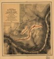 | 4,606 × 5,038 (66.39 MB) | Fæ (talk | contribs) | LOC Maps https://www.loc.gov/item/99448908/ #9969 |
You cannot overwrite this file.
File usage on Commons
The following page uses this file: