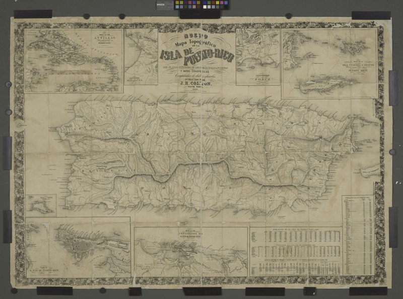
File:Mapa topografico de la isla de Puerto Rico; Contornos de Ponce (inset with title of full page map); Mapa de los contornos de San Juan de Puerto Rico (inset); Plano de San Juan de Puerto Rico NYPL1808082.tiff
Jump to navigation
Jump to search
Size of this JPG preview of this TIF file: 800 × 593 pixels. Other resolutions: 320 × 237 pixels | 640 × 474 pixels | 1,024 × 758 pixels | 1,280 × 948 pixels | 2,560 × 1,896 pixels | 6,510 × 4,822 pixels.
Original file (6,510 × 4,822 pixels, file size: 89.81 MB, MIME type: image/tiff)
Captions
Captions
Add a one-line explanation of what this file represents
Summary[edit]
| Description | Mapa topografico de la isla de Puerto Rico; Contornos de Ponce [inset with title of full page map]; Mapa de los contornos de San Juan de Puerto Rico [inset] ; Plano de San Juan de Puerto Rico [inset.; Maps of North America. / Countries / Puerto Rico | |||||||||||||||||||||||
| Date | ||||||||||||||||||||||||
| Source |
http://digitalgallery.nypl.org/nypldigital/dgkeysearchdetail.cfm?imageID=1808084
|
|||||||||||||||||||||||
| Author | ||||||||||||||||||||||||
| Permission (Reusing this file) |
From The Lionel Pincus and Princess Firyal Map Division. http://maps.nypl.org
|
|||||||||||||||||||||||
| Location | Stephen A. Schwarzman Building / The Lionel Pincus and Princess Firyal Map Division | |||||||||||||||||||||||
| Digital item published | 1-14-2010; updated 3-25-2011 | |||||||||||||||||||||||
| Digital ID | 1808082 | |||||||||||||||||||||||

The making of this file was supported by Wikimedia UK.
To see other files made with the support of Wikimedia UK, please see the category Supported by Wikimedia UK.
|
File history
Click on a date/time to view the file as it appeared at that time.
| Date/Time | Thumbnail | Dimensions | User | Comment | |
|---|---|---|---|---|---|
| current | 07:59, 10 May 2014 |  | 6,510 × 4,822 (89.81 MB) | Fæ (talk | contribs) | GWToolset: Creating mediafile for Fæ. Tranche 4 -12906 reload @07:10 BST, 10 May 2014 |
You cannot overwrite this file.
File usage on Commons
There are no pages that use this file.