File:Marcellus Thermal Maturity.png
Jump to navigation
Jump to search

Size of this preview: 354 × 599 pixels. Other resolutions: 142 × 240 pixels | 283 × 480 pixels | 454 × 768 pixels | 605 × 1,024 pixels | 1,766 × 2,988 pixels.
Original file (1,766 × 2,988 pixels, file size: 442 KB, MIME type: image/png)
Captions
Captions
Add a one-line explanation of what this file represents
Summary[edit]
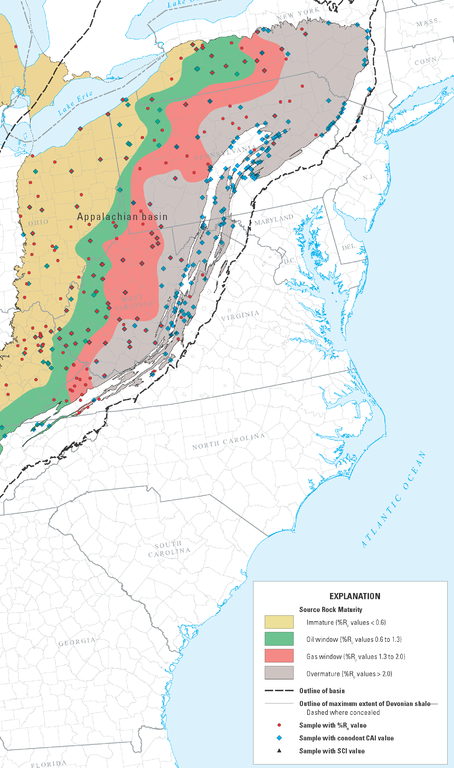
Thermal maturity map of the Marcellus shale (USGS)
Licensing[edit]
This image is in the public domain in the United States because it only contains materials that originally came from the United States Geological Survey, an agency of the United States Department of the Interior. For more information, see the official USGS copyright policy.
|
Source[edit]
Joseph A. East, Christopher S. Swezey, John E. Repetski, and Daniel O. Hayba, “Thermal maturity map of Devonian shale in the Illinois, Michigan, and Appalachian basins of North America”, US Geological Survey, Scientific Investigations Map 3214, 2012.
File history
Click on a date/time to view the file as it appeared at that time.
| Date/Time | Thumbnail | Dimensions | User | Comment | |
|---|---|---|---|---|---|
| current | 02:43, 27 November 2014 | | 1,766 × 2,988 (442 KB) | Plazak (talk | contribs) | Thermal maturity map of the Marcellus shale (USGS) |
You cannot overwrite this file.
File usage on Commons
There are no pages that use this file.
File usage on other wikis
The following other wikis use this file:
- Usage on en.wikipedia.org