File:NGMDB databases linked together.jpg
Jump to navigation
Jump to search
No higher resolution available.
NGMDB_databases_linked_together.jpg (600 × 301 pixels, file size: 25 KB, MIME type: image/jpeg)
Captions
Captions
Add a one-line explanation of what this file represents


Summary[edit]
| Description |
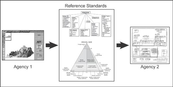
English: Figure 12. A single, monolithic system design shared by all agencies is unlikely. Rather, interoperability among the many agency databases linked together by the NGMDB database is the most logical design philosophy. In this diagram, we envision that map data from one agency (the Kentucky Geological Survey, http://www.uky.edu/KGS/) will be translated into reference standards (the data model and science language standards adopted by the NGMDB) and translated out to the criteria required by another agency (the Idaho Geological Survey’s Geologic Map Data Model, http://www.idahogeology.org/Lab/datamodel.htm). This approach also could permit the NGMDB to coordinate the translation and display of multiple agency databases. In this diagram, the reference standards are represented by a schematic of the draft NGMDB data model (discussed in another paper in this volume) and an example of science language from Folk (1954, fig. 1a) showing a rock classification based on mud-sand-gravel content. |
| Date | |
| Source | The National Geologic Map Database Project: Overview and Progress U.S. Geological Survey Open-File Report 03–471 |
| Author | David R. Soller1 and Thomas M. Berg |
Licensing[edit]
This work is in the public domain in the United States because it is a work prepared by an officer or employee of the United States Government as part of that person’s official duties under the terms of Title 17, Chapter 1, Section 105 of the US Code.
Note: This only applies to original works of the Federal Government and not to the work of any individual U.S. state, territory, commonwealth, county, municipality, or any other subdivision. This template also does not apply to postage stamp designs published by the United States Postal Service since 1978. (See § 313.6(C)(1) of Compendium of U.S. Copyright Office Practices). It also does not apply to certain US coins; see The US Mint Terms of Use.
|
 | |
| This file has been identified as being free of known restrictions under copyright law, including all related and neighboring rights. | ||
File history
Click on a date/time to view the file as it appeared at that time.
| Date/Time | Thumbnail | Dimensions | User | Comment | |
|---|---|---|---|---|---|
| current | 00:32, 9 October 2008 | | 600 × 301 (25 KB) | Mdd (talk | contribs) | == Summary == {{Information |Description={{en|1= Figure 12. A single, monolithic system design shared by all agencies is unlikely. Rather, interoperability among the many agency databases linked together by the NGMDB database is the most logical design ph |
You cannot overwrite this file.
File usage on Commons
There are no pages that use this file.
File usage on other wikis
The following other wikis use this file:
- Usage on en.wikipedia.org
- Usage on ja.wikipedia.org