File:NURP project map.jpg
Jump to navigation
Jump to search

Size of this preview: 800 × 511 pixels. Other resolutions: 320 × 204 pixels | 640 × 409 pixels | 1,040 × 664 pixels.
Original file (1,040 × 664 pixels, file size: 106 KB, MIME type: image/jpeg)
Captions
Captions
Add a one-line explanation of what this file represents
Summary[edit]
| Description |
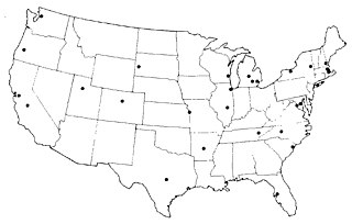
English: Map of United States showing the locations of 28 projects conducted for the Nationwide Urban Runoff Program (1979-1983). |
| Date | |
| Source | U.S. Environmental Protection Agency, Washington, DC (1983)."Results of the Nationwide Urban Runoff Program: Executive Summary." |
| Author | U.S. EPA |
Licensing[edit]
This image (or other media) is a work of an Environmental Protection Agency employee, taken or made as part of that person's official duties. As works of the U.S. federal government, all EPA images are in the public domain.
|
||
File history
Click on a date/time to view the file as it appeared at that time.
| Date/Time | Thumbnail | Dimensions | User | Comment | |
|---|---|---|---|---|---|
| current | 05:22, 26 February 2008 | | 1,040 × 664 (106 KB) | Moreau1 (talk | contribs) | {{Information |Description=Map of U.S. Showing Locations of 28 NURP Project |Source=U.S. Environmental Protection Agency, Washington, DC |Date=1983 |Author= |Permission= |other_versions=http://www.epa.gov/npdes/pubs/sw_nurp_exec_summary.pdf }} |
You cannot overwrite this file.
File usage on Commons
There are no pages that use this file.
File usage on other wikis
The following other wikis use this file:
- Usage on en.wikipedia.org