File:Nan bei yang he tu. LOC gm71005215.tif
Jump to navigation
Jump to search

Size of this JPG preview of this TIF file: 430 × 600 pixels. Other resolutions: 172 × 240 pixels | 344 × 480 pixels | 550 × 768 pixels | 734 × 1,024 pixels | 1,468 × 2,048 pixels | 5,106 × 7,122 pixels.
Original file (5,106 × 7,122 pixels, file size: 104.04 MB, MIME type: image/tiff)
Captions
Captions
Add a one-line explanation of what this file represents
Summary[edit]
| Description |
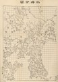
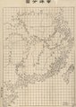
English: A map of the Chinese coastline and adjacent seas. Scale c. 1:10,000,000. Covers East Asia coastal area from Kamchatka Peninsula to Indo-China Penisula. Wood block print. Relief shown pictorially. One grid equal 400 li. Available also through the Library of Congress Web site as a raster image. Previous call number: G9237.E3 1864 .H8 Vault |
||
| Title | English: Combined Map of the Northern and Southern Oceans
中文:南北洋合圖, Nanbeiyang Hetu |
||
| Shelf ID | G9237.E3 1870 .H8 | ||
| Date | |||
| Source | https://www.loc.gov/item/gm71005215/ | ||
| Author | Hubei Guanshuju (湖北官书局) | ||
| Permission (Reusing this file) |
|
||
| Other versions |
|
||
| Location | East China Sea | ||
| Part of | American Memory · General Maps · Catalog · Geography And Map Division | ||
| Subject | Maps · East China Sea |


Licensing[edit]
|
This is a faithful photographic reproduction of a two-dimensional, public domain work of art. The work of art itself is in the public domain for the following reason:
The official position taken by the Wikimedia Foundation is that "faithful reproductions of two-dimensional public domain works of art are public domain".
This photographic reproduction is therefore also considered to be in the public domain in the United States. In other jurisdictions, re-use of this content may be restricted; see Reuse of PD-Art photographs for details. | ||||
File history
Click on a date/time to view the file as it appeared at that time.
| Date/Time | Thumbnail | Dimensions | User | Comment | |
|---|---|---|---|---|---|
| current | 06:06, 7 September 2018 |  | 5,106 × 7,122 (104.04 MB) | Fæ (talk | contribs) | LOC Maps https://www.loc.gov/item/gm71005215/ #14399 |
You cannot overwrite this file.
File usage on Commons
The following 7 pages use this file:
- File:Bei yang fen tu. LOC gm71005226.jpg
- File:Bei yang fen tu. LOC gm71005226.tif
- File:Dian Yue Yuenan lian jie yu tu. LOC gm71005069.jpg
- File:Dian Yue Yuenan lian jie yu tu. LOC gm71005069.tif
- File:Nan bei yang he tu. LOC gm71005215.jpg
- File:Nan yang fen tu. LOC gm71005139.jpg
- File:Nan yang fen tu. LOC gm71005139.tif
Metadata
Categories:
- Maps in the Library of Congress
- 1870 maps of Asia
- Chinese-language maps of China
- Chinese-language maps of Japan
- Bohai Bay
- Old maps of the Yellow Sea
- Old maps of the Sea of Japan
- Maps of the East China Sea
- Old maps of the South China Sea
- Hubei Guanshuju
- 1870 maps of Taiwan
- Old maps of Hainan
- 19th-century maps of Korea
- 19th-century maps of Japan
- Old maps of Sakhalin
- Maps of Primorsky Krai
- Old maps of Kamchatka
- Maps of the Great Wall of China
- Willow Palisade
- Maps of Amur River
- Old maps of Vietnam
- Old maps of East Asia