File:Neapel sozioökonomisch.svg
Jump to navigation
Jump to search

Size of this PNG preview of this SVG file: 800 × 598 pixels. Other resolutions: 320 × 239 pixels | 640 × 478 pixels | 1,024 × 765 pixels | 1,280 × 957 pixels | 2,560 × 1,913 pixels | 938 × 701 pixels.
Original file (SVG file, nominally 938 × 701 pixels, file size: 192 KB)
Captions
Captions
Add a one-line explanation of what this file represents
Summary[edit]
| Description |
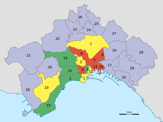
Deutsch: Sozioökonomische Karte von Neapel:
|
| Date | |
| Source |
Own work, using data by
|
| Author | NordNordWest |

|
This map has been made or improved in the German Kartenwerkstatt (Map Lab). You can propose maps to improve as well.
|
Licensing[edit]
| This work contains information from OpenStreetMap, which is made available under the Open Database License (ODbL).
The ODbL does not require any particular license for maps produced from ODbL data. Prior to 1 August 2020, map tiles produced by the OpenStreetMap Foundation were licensed under the CC-BY-SA-2.0 license. Maps produced by other people may be subject to other licences. |
File history
Click on a date/time to view the file as it appeared at that time.
| Date/Time | Thumbnail | Dimensions | User | Comment | |
|---|---|---|---|---|---|
| current | 13:16, 18 November 2012 | | 938 × 701 (192 KB) | NordNordWest (talk | contribs) | upd |
| 20:51, 13 November 2012 |  | 938 × 701 (186 KB) | NordNordWest (talk | contribs) | == {{int:filedesc}} == {{Information |Description= {{de|Sozioökonomische Karte von Neapel: * grün: Zentrum, wohlhabend * gelb: Zentrum, mittelwohlhabend * rot: Zentrum, ärmlich * violett: periphere Stadtteile}} |Source={{Own}}, using data by * OpenS... |
You cannot overwrite this file.
File usage on Commons
There are no pages that use this file.
File usage on other wikis
The following other wikis use this file:
- Usage on de.wikipedia.org