File:Nebraska and Kanzas LOC 2017586283.tif
Jump to navigation
Jump to search
Size of this JPG preview of this TIF file: 708 × 599 pixels. Other resolutions: 284 × 240 pixels | 567 × 480 pixels | 907 × 768 pixels | 1,209 × 1,024 pixels | 2,419 × 2,048 pixels | 5,311 × 4,497 pixels.
Original file (5,311 × 4,497 pixels, file size: 68.33 MB, MIME type: image/tiff)
Captions
Captions
Add a one-line explanation of what this file represents
Summary[edit]
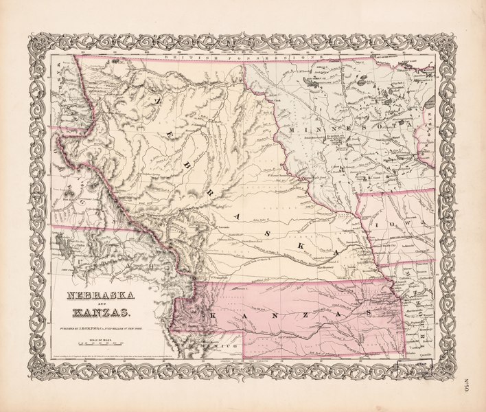
| Description |
English: Relief shown by hachures. Shows routes explored for Pacific railroad by Captain J.W. Gunnison and Lieutenant E.G. Beckwith; shows route for a proposed railroad to the West Coast as Governor Stevens' Route & line of proposed Pacific railroad; and adjacent portions of neighboring states. Hand colored in pink to define territory and state boundaries. "Published by J.H. Colton & Co. No. 172 William St. New York.; Entered according to Act of Congress in the year 1855 by J.H. Colton & Co. in the Clerks Office of the District Court of the United Stated for the Southern District of New York." Prime meridians: Greenwich and Washington. Includes notes. At lower right: No. 50. Available also through the Library of Congress Web site as a raster image. |
||
| Title | Nebraska and Kanzas | ||
| Shelf ID | G4190 1855 .J4 | ||
| Date | |||
| Source | https://www.loc.gov/item/2017586283/ | ||
| Author | J.H. Colton & Co. | ||
| Permission (Reusing this file) |
|
||
| Other versions |
|
||
| Location | United States · Nebraska · Kansas. · Nebraska. · Kansas | ||
| Part of | American Memory · General Maps · Catalog · Geography And Map Division | ||
| Subject | United States · Maps · Nebraska · Kansas |


Licensing[edit]
|
This is a faithful photographic reproduction of a two-dimensional, public domain work of art. The work of art itself is in the public domain for the following reason:
The official position taken by the Wikimedia Foundation is that "faithful reproductions of two-dimensional public domain works of art are public domain".
This photographic reproduction is therefore also considered to be in the public domain in the United States. In other jurisdictions, re-use of this content may be restricted; see Reuse of PD-Art photographs for details. | ||||
File history
Click on a date/time to view the file as it appeared at that time.
| Date/Time | Thumbnail | Dimensions | User | Comment | |
|---|---|---|---|---|---|
| current | 10:35, 3 August 2018 |  | 5,311 × 4,497 (68.33 MB) | Fæ (talk | contribs) | LOC Maps https://www.loc.gov/item/2017586283/ #20725 |
You cannot overwrite this file.
File usage on Commons
The following page uses this file: