File:Northern Europe ESA393950.tiff

Original file (4,727 × 4,091 pixels, file size: 42.15 MB, MIME type: image/tiff)
Captions
Captions
Summary[edit]
| Description |
English: The Copernicus Sentinel-3B satellite captured this rare cloud-free view of Northern Europe on 8 May 2018 at 09:33 GMT (11:33 CEST). Features over land and water can been seen clearly such as different types of land cover, snow and also a plume of phytoplankton in the North Sea. The image was taken by the satellite’s ocean and land colour Instrument, which features 21 distinct bands, a resolution of 300 m and a swath width of 1270 km. The instrument can be used to monitor aquatic biological productivity and marine pollution, and over land it can be used to monitor the health of vegetation. Sentinel-3B’s instrument package also includes a sea and land surface temperature radiometer, a synthetic aperture radar altimeter and a microwave radiometer. Sentinel-3B was launched from Russia on 25 April and joins its twin, Sentinel-3A, in orbit. The pairing of the two satellites optimises coverage and data delivery for Europe’s Copernicus environmental monitoring programme. |
| Date | |
| Source | http://www.esa.int/spaceinimages/Images/2018/05/Northern_Europe |
| Author | European Space Agency |
| Permission (Reusing this file) |
contains modified Copernicus Sentinel data (2018), processed by EUMETSAT,CC BY-SA 3.0 IGO |
| Title | Northern Europe |
| System | Copernicus |
| Mission | Sentinel-3 |
| Activity | Observing the Earth |
Licensing[edit]
- You are free:
- to share – to copy, distribute and transmit the work
- to remix – to adapt the work
- Under the following conditions:
- attribution – You must give appropriate credit, provide a link to the license, and indicate if changes were made. You may do so in any reasonable manner, but not in any way that suggests the licensor endorses you or your use.
- share alike – If you remix, transform, or build upon the material, you must distribute your contributions under the same or compatible license as the original.

|
This image contains data from a satellite in the Copernicus Programme, such as Sentinel-1, Sentinel-2 or Sentinel-3. Attribution is required when using this image.
Attribution: Contains modified Copernicus Sentinel data {{{year}}}
The use of Copernicus Sentinel Data is regulated under EU law (Commission Delegated Regulation (EU) No 1159/2013 and Regulation (EU) No 377/2014). Relevant excerpts:
Free access shall be given to GMES dedicated data [...] made available through GMES dissemination platforms [...].
Access to GMES dedicated data [...] shall be given for the purpose of the following use in so far as it is lawful:
GMES dedicated data [...] may be used worldwide without limitations in time.
GMES dedicated data and GMES service information are provided to users without any express or implied warranty, including as regards quality and suitability for any purpose. |
File history
Click on a date/time to view the file as it appeared at that time.
| Date/Time | Thumbnail | Dimensions | User | Comment | |
|---|---|---|---|---|---|
| current | 15:57, 9 May 2018 | 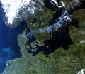 | 4,727 × 4,091 (42.15 MB) | Fæ (talk | contribs) | European Space Agency, Id 393950, http://www.esa.int/spaceinimages/Images/2018/05/Northern_Europe, User:Fæ/Project_list/ESA |
You cannot overwrite this file.
File usage on Commons
The following page uses this file:
- File:Sentinel-3B-Aufnahme von Nordeuropa ESA393981.tiff (file redirect)