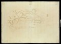
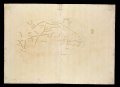
File:Orbis Typus Universalis Juxta Hydrographorum Traditionem. RMG L7405-001.tiff
Jump to navigation
Jump to search

Size of this JPG preview of this TIF file: 800 × 583 pixels. Other resolutions: 320 × 233 pixels | 640 × 467 pixels | 1,024 × 746 pixels | 1,280 × 933 pixels | 2,560 × 1,866 pixels | 4,800 × 3,499 pixels.
Original file (4,800 × 3,499 pixels, file size: 48.05 MB, MIME type: image/tiff)
Captions
Captions
Add a one-line explanation of what this file represents
Summary[edit]
| Author |
Claudius Ptolemy; Martin Waldseemuller |
| Description |
English: Orbis Typus Universalis Juxta Hydrographorum Traditionem.Woodcut, coloured world map on a single sheet. 'Orbis Typus Universalis Juxta Hydrographorum Traditionem. (Trans. The figure of the whole globe according to the tradition of hydrographers.) Published in Strasbourg. from Martin Waldseemuller edition of Ptolemy's Geographia (copy at PBC3994). Orbis Typus Universalis Juxta Hydrographorum Traditionem. Recto. G201:1/63 |
| Date | 1513 |
| Dimensions | Overall: 46.5 cm x 64 cm |
| Notes | This map is an updated version of one produced from Ptolemy's 2nd century account of world geography. In Europe, the voyages of exploration of the late fifteenth and early sixteenth century radically changed the way people saw the world. The ‘hydrographers’ referred to in the title of the map are those European navigators who sailed to the Americas, and around the southern tip of Africa. |
| Source/Photographer | http://collections.rmg.co.uk/collections/objects/384029 |
| Permission (Reusing this file) |
The original artefact or artwork has been assessed as public domain by age, and faithful reproductions of the two dimensional work are also public domain. No permission is required for reuse for any purpose. The text of this image record has been derived from the Royal Museums Greenwich catalogue and image metadata. Individual data and facts such as date, author and title are not copyrightable, but reuse of longer descriptive text from the catalogue may not be considered fair use. Reuse of the text must be attributed to the "National Maritime Museum, Greenwich, London" and a Creative Commons CC-BY-NC-SA-3.0 license may apply if not rewritten. Refer to Royal Museums Greenwich copyright. |
| Other versions |
|
| Identifier | id number: G201:1/63 |
| Collection | Charts and maps |


Licensing[edit]
|
This is a faithful photographic reproduction of a two-dimensional, public domain work of art. The work of art itself is in the public domain for the following reason:
The official position taken by the Wikimedia Foundation is that "faithful reproductions of two-dimensional public domain works of art are public domain".
This photographic reproduction is therefore also considered to be in the public domain in the United States. In other jurisdictions, re-use of this content may be restricted; see Reuse of PD-Art photographs for details. | ||||
File history
Click on a date/time to view the file as it appeared at that time.
| Date/Time | Thumbnail | Dimensions | User | Comment | |
|---|---|---|---|---|---|
| current | 03:00, 30 August 2017 |  | 4,800 × 3,499 (48.05 MB) | Fæ (talk | contribs) | Royal Museums Greenwich Charts and maps, http://collections.rmg.co.uk/collections/objects/384029 |
You cannot overwrite this file.
File usage on Commons
The following 5 pages use this file:
- File:Orbis Typus Universalis Juxta Hydrographorum Traditionem. RMG F1973.tiff
- File:Orbis Typus Universalis Juxta Hydrographorum Traditionem. RMG L6851-001.tiff
- File:Orbis Typus Universalis Juxta Hydrographorum Traditionem. RMG L6851-002.tiff
- File:Orbis Typus Universalis Juxta Hydrographorum Traditionem. RMG L7405-001.tiff
- File:Orbis Typus Universalis Juxta Hydrographorum Traditionem. RMG L7405-002.tiff