File:Photocopy of map (from Superior Court of Chatham County Land Records, Book 2G, p. 299) John McKinnon (County Surveyor), delineator 11 January 1817 PLAT OF SITE, SHOWING EASTERN HABS GA,26-SAV,82-7.tif
Jump to navigation
Jump to search

Size of this JPG preview of this TIF file: 800 × 574 pixels. Other resolutions: 320 × 230 pixels | 640 × 459 pixels | 1,024 × 734 pixels | 1,280 × 918 pixels | 2,560 × 1,836 pixels | 5,000 × 3,586 pixels.
Original file (5,000 × 3,586 pixels, file size: 17.1 MB, MIME type: image/tiff)
Captions
Captions
Add a one-line explanation of what this file represents
Summary[edit]
| Title |
Photocopy of map (from Superior Court of Chatham County Land Records, Book 2G, p. 299) John McKinnon (County Surveyor), delineator 11 January 1817 PLAT OF SITE, SHOWING EASTERN PORTION OF BUILDING - William Taylor Store, 204 West Bay Street, Savannah, Chatham County, GA |
|||
| Depicted place | Georgia; Chatham County; Savannah | |||
| Dimensions | 5 x 7 in. | |||
| Current location |
Library of Congress Prints and Photographs Division Washington, D.C. 20540 USA http://hdl.loc.gov/loc.pnp/pp.print |
|||
| Accession number |
HABS GA,26-SAV,82-7 |
|||
| Credit line |
|
|||
| Source | https://www.loc.gov/pictures/item/ga0142.photos.056116p | |||
| Permission (Reusing this file) |
|

File history
Click on a date/time to view the file as it appeared at that time.
| Date/Time | Thumbnail | Dimensions | User | Comment | |
|---|---|---|---|---|---|
| current | 15:34, 13 July 2014 | 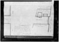 | 5,000 × 3,586 (17.1 MB) | Fæ (talk | contribs) | GWToolset: Creating mediafile for Fæ. HABS 09 July 2014 (801:1000) |
You cannot overwrite this file.
File usage on Commons
The following page uses this file: