File:Rennes - Campus de Villejean map-fr.svg
Jump to navigation
Jump to search

Size of this PNG preview of this SVG file: 526 × 599 pixels. Other resolutions: 211 × 240 pixels | 421 × 480 pixels | 674 × 768 pixels | 899 × 1,024 pixels | 1,798 × 2,048 pixels | 769 × 876 pixels.
Original file (SVG file, nominally 769 × 876 pixels, file size: 54 KB)
Captions
Captions
Add a one-line explanation of what this file represents
Summary[edit]
| Description |
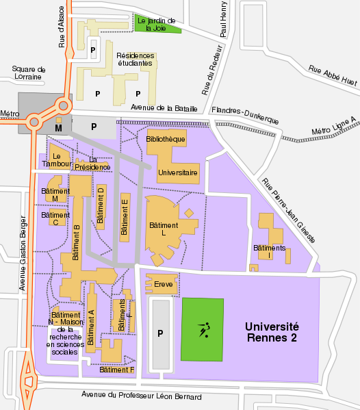
English: Map of the Villejean campus of Rennes 2 university.
|
||
| Date | |||
| Source | See the image in its original context on the OpenStreetMap wiki page for Rennes. | ||
| Author | OpenStreetMap contributors and Sémhur | ||
| Permission (Reusing this file) |
All OpenStreetMap data and maps are Creative Commons "CC-BY-SA 2.0" licensed. | ||
| Other versions | |||
| Attribution (required by the license) | © Sémhur / Wikimedia Commons / | ||
| SVG | W3C-validity not checked.
|
||
| Graphic Lab |

| Camera location | | View this and other nearby images on: OpenStreetMap |
|---|
Licensing[edit]
This file is licensed under the Creative Commons Attribution-Share Alike 2.0 Generic license.
- You are free:
- to share – to copy, distribute and transmit the work
- to remix – to adapt the work
- Under the following conditions:
- attribution – You must give appropriate credit, provide a link to the license, and indicate if changes were made. You may do so in any reasonable manner, but not in any way that suggests the licensor endorses you or your use.
- share alike – If you remix, transform, or build upon the material, you must distribute your contributions under the same or compatible license as the original.
File history
Click on a date/time to view the file as it appeared at that time.
| Date/Time | Thumbnail | Dimensions | User | Comment | |
|---|---|---|---|---|---|
| current | 17:00, 20 August 2009 | | 769 × 876 (54 KB) | Sémhur (talk | contribs) | + bâtiments de la résidence universitaire |
| 16:47, 20 August 2009 |  | 769 × 876 (52 KB) | Sémhur (talk | contribs) | Suppression des anciens gymnases, résidences universitaires d'une couleur différente. | |
| 19:20, 18 August 2009 |  | 769 × 876 (57 KB) | Sémhur (talk | contribs) | =={{int:filedesc}}== {{Information |Description= {{en|1=Map of the Villejean campus of Rennes 2 university.}} {{fr|1=Carte du campus de Villejean, de l'université de Rennes 2.}} |Source=See the im |
You cannot overwrite this file.
File usage on Commons
The following 2 pages use this file:
File usage on other wikis
The following other wikis use this file:
- Usage on fr.wikipedia.org