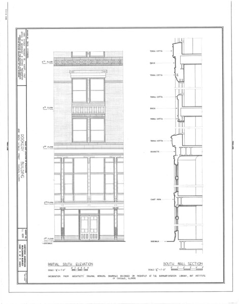
File:Rookery Building, 209 South LaSalle Street, Chicago, Cook County, IL HABS ILL,16-CHIG,31- (sheet 6 of 8).tif
Jump to navigation
Jump to search
Size of this JPG preview of this TIF file: 471 × 599 pixels. Other resolutions: 189 × 240 pixels | 377 × 480 pixels | 604 × 768 pixels | 805 × 1,024 pixels | 1,611 × 2,048 pixels | 7,584 × 9,642 pixels.
Original file (7,584 × 9,642 pixels, file size: 870 KB, MIME type: image/tiff)
Captions
Captions
Add a one-line explanation of what this file represents
Summary[edit]
| HABS ILL,16-CHIG,31- (sheet 6 of 8) - Rookery Building, 209 South LaSalle Street, Chicago, Cook County, IL | ||||
|---|---|---|---|---|
| Photographer |
Related names:
|
|||
| Title |
HABS ILL,16-CHIG,31- (sheet 6 of 8) - Rookery Building, 209 South LaSalle Street, Chicago, Cook County, IL |
|||
| Depicted place | Illinois; Cook County; Chicago | |||
| Date | Documentation compiled after 1933 | |||
| Dimensions | 19 x 24 in. (B size) | |||
| Current location |
Library of Congress Prints and Photographs Division Washington, D.C. 20540 USA http://hdl.loc.gov/loc.pnp/pp.print |
|||
| Accession number |
HABS ILL,16-CHIG,31- (sheet 6 of 8) |
|||
| Credit line |
|
|||
| Notes |
|
|||
| References |
|
|||
| Source | https://www.loc.gov/pictures/item/il0038.sheet.00006a | |||
| Permission (Reusing this file) |
|
|||
| Other versions |
.png) .png) .png) .png) .png) .png) .png) .png) |
|||

| Camera location | | View this and other nearby images on: OpenStreetMap |
|---|
File history
Click on a date/time to view the file as it appeared at that time.
| Date/Time | Thumbnail | Dimensions | User | Comment | |
|---|---|---|---|---|---|
| current | 02:03, 16 July 2014 |  | 7,584 × 9,642 (870 KB) | Fæ (talk | contribs) | GWToolset: Creating mediafile for Fæ. HABS 11 July 2014 (1001:1200) |
You cannot overwrite this file.
File usage on Commons
The following 2 pages use this file: