File:Royaumes combattants 250 aC.svg
Jump to navigation
Jump to search

Size of this PNG preview of this SVG file: 568 × 384 pixels. Other resolutions: 320 × 216 pixels | 640 × 433 pixels | 1,024 × 692 pixels | 1,280 × 865 pixels | 2,560 × 1,731 pixels.
Original file (SVG file, nominally 568 × 384 pixels, file size: 716 KB)
Captions
Captions
Add a one-line explanation of what this file represents
Summary[edit]
| Description |
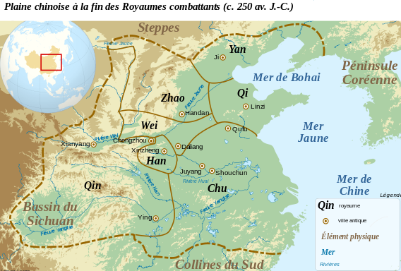
Français : Carte de la plaine Chinoise à la fin l'époque des royaumes combattants, avant les conquêtes du Qin (c. 250 av. J.-C.). Le tracé des frontières est approximatif. A partir des données : J. Gernet, Le monde chinois, 1. De l'âge du bronze au Moyen-Âge, 2100 av. J.-C.-Xe siècle après J.-C., Paris, 2005, p. 109 ; J. Gernet, La Chine ancienne, Paris, 2005 ; M. E. Lewis, « Warring State Political History », p. 587-650 dans M. Loeve et E. L. Shaughnessy (dir.), The Cambridge History of Ancient China, From the Origins of Civilization to 221 BC, Cambridge, 1999. English: Map of the Chinese plain, before the end of the Warring States Period and Qin conquests, c. 250 B.C. |
||
| Date | |||
| Source |
This file was derived from: Chinese plain 5c. BC-fr.svg: |
||
| Author | Zunkir | ||
| SVG development |
|
Licensing[edit]
I, the copyright holder of this work, hereby publish it under the following license:
This file is licensed under the Creative Commons Attribution-Share Alike 3.0 Unported license.
- You are free:
- to share – to copy, distribute and transmit the work
- to remix – to adapt the work
- Under the following conditions:
- attribution – You must give appropriate credit, provide a link to the license, and indicate if changes were made. You may do so in any reasonable manner, but not in any way that suggests the licensor endorses you or your use.
- share alike – If you remix, transform, or build upon the material, you must distribute your contributions under the same or compatible license as the original.
Original upload log[edit]
This image is a derivative work of the following images:
- Chinese plain 5c. BC-fr.svg licensed with Cc-by-sa-3.0
Uploaded with derivativeFX
File history
Click on a date/time to view the file as it appeared at that time.
| Date/Time | Thumbnail | Dimensions | User | Comment | |
|---|---|---|---|---|---|
| current | 20:35, 31 July 2012 | | 568 × 384 (716 KB) | Zunkir (talk | contribs) | Modif carte de localisation. |
| 21:33, 2 March 2012 |  | 568 × 384 (726 KB) | Zunkir (talk | contribs) | Modifications des frontières. | |
| 21:46, 22 February 2012 |  | 568 × 384 (726 KB) | Zunkir (talk | contribs) | == {{int:filedesc}} == {{Information |Description={{fr|1=Carte de la plaine Chinoise à la fin l'époque des royaumes combattants, avant les conquêtes du Qin (c. 250 av. J.-C.).}}{{en|1=Map of the Chinese plain, before the end of the Warring States Perio |
You cannot overwrite this file.
File usage on Commons
The following page uses this file:
File usage on other wikis
The following other wikis use this file:
- Usage on en.wikipedia.org
- Usage on fr.wikipedia.org