File:STS035-502-4.jpg
Jump to navigation
Jump to search

Size of this preview: 595 × 600 pixels. Other resolutions: 238 × 240 pixels | 476 × 480 pixels | 762 × 768 pixels | 1,016 × 1,024 pixels | 2,031 × 2,048 pixels | 3,904 × 3,936 pixels.
Original file (3,904 × 3,936 pixels, file size: 10.83 MB, MIME type: image/jpeg)
Captions
Captions
Add a one-line explanation of what this file represents
Summary[edit]
| Description |
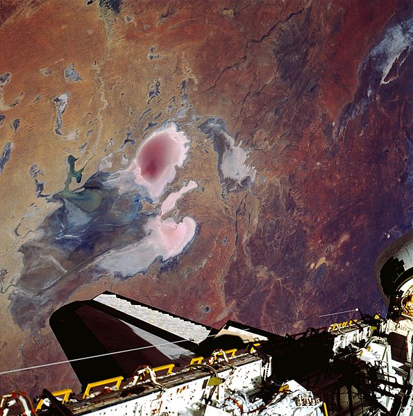
English: Lake Eyre is large in aerial extent (covers about 3600 square miles—9300 square kilometers), and its total drainage basin is even larger. The lake is divided into two unequal parts: Lake Eyre North and a much smaller Lake Eyre South. The two basins are connected by a narrow canal known as the Goyder Channel. Three specific “bays” are identified at the southern end of the north basin: Belt Bay (whitish lobe, southwest); Madigan Bay (multicolored, southeast); and the thin, elongated Jackboot Bay which is located between the larger bays. Belt Bay and Madigan Bay have the thickest crusts of dissolved salts--up to 15 inches (40 centimeters) on their surfaces. Lake Eyre is the lowest point in Australia at about 50 feet (15 meters) below sea level. This lake is also Australia's largest lakebed, although it is an ephemeral salt lake that receives less than 5 inches (125 millimeters) annual average precipitation. Records indicate that the lake has only been completely filled with water three times in the 20th century (1950, 1974, and 1984). In this photo the lake shows Eyre drying down from a higher level in October. The light, colored feature in the upper right corner of the picture is the northern end of Lake Torrens which is also another ephemeral lake. Part of the Space Shuttle cargo bay is visible along the bottom edge of the image. |
| Date | |
| Source | http://eol.jsc.nasa.gov/scripts/sseop/photo.pl?mission=STS035&roll=502&frame=4 |
| Author | NASA/STS-35 |
This image or video was catalogued by Johnson Space Center of the United States National Aeronautics and Space Administration (NASA) under Photo ID: STS035-502-4. This tag does not indicate the copyright status of the attached work. A normal copyright tag is still required. See Commons:Licensing. Other languages:
|
Licensing[edit]
This file is in the public domain in the United States because it was created by the Image Science & Analysis Laboratory, of the NASA Johnson Space Center. NASA copyright policy states that "NASA material is not protected by copyright unless noted". (NASA media use guidelines or Conditions of Use of Astronaut Photographs).
Photo source: STS035-502-4.
|
File history
Click on a date/time to view the file as it appeared at that time.
| Date/Time | Thumbnail | Dimensions | User | Comment | |
|---|---|---|---|---|---|
| current | 12:13, 12 May 2013 | | 3,904 × 3,936 (10.83 MB) | Ras67 (talk | contribs) | original |
| 07:24, 14 August 2011 |  | 2,000 × 2,016 (685 KB) | Exploitcorporations (talk | contribs) |
You cannot overwrite this file.
File usage on Commons
There are no pages that use this file.
File usage on other wikis
The following other wikis use this file:
- Usage on bg.wikipedia.org
- Usage on ca.wikipedia.org
- Usage on en.wikipedia.org
- Usage on es.wikipedia.org
- Usage on et.wikipedia.org
- Usage on ja.wikipedia.org
- Usage on sk.wikipedia.org
- Usage on sr.wikipedia.org
- Usage on uk.wikipedia.org
- Usage on zh-yue.wikipedia.org