File:SWE-Map Vägverksregioner-Län.svg
Jump to navigation
Jump to search

Size of this PNG preview of this SVG file: 263 × 599 pixels. Other resolutions: 105 × 240 pixels | 211 × 480 pixels | 337 × 768 pixels | 450 × 1,024 pixels | 900 × 2,048 pixels | 290 × 660 pixels.
Original file (SVG file, nominally 290 × 660 pixels, file size: 97 KB)
Captions
Captions
Add a one-line explanation of what this file represents
| Description |
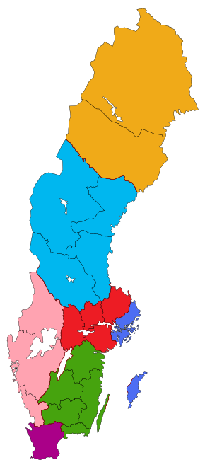
English: A map of the road administration regions and counties of Sweden. The colour shows which road administration region a particular countie belongs to.
Svenska: Sveriges vägverksregioner och län. Färgerna anger vilken vägverksregion ett län tillhör.
Stockholm
Mälardalen
Sydöst
Skåne
Väst
Mitt
Norr |
| Date | |
| Source |
Made by Lokal_Profil
|
| Author | Lokal_Profil |
| Permission (Reusing this file) |
This file is licensed under the Creative Commons Attribution-Share Alike 2.5 Generic license. Attribution: Lokal_Profil
|
File history
Click on a date/time to view the file as it appeared at that time.
| Date/Time | Thumbnail | Dimensions | User | Comment | |
|---|---|---|---|---|---|
| current | 22:34, 24 May 2010 | | 290 × 660 (97 KB) | Lokal Profil (talk | contribs) | Swapping around to make closer to Trafikverket-Län map |
| 22:30, 24 May 2010 |  | 290 × 660 (97 KB) | Lokal Profil (talk | contribs) | Correction | |
| 22:20, 24 May 2010 |  | 290 × 660 (97 KB) | Lokal Profil (talk | contribs) | {{Information |Description={{en|A map of the road administration regions and counties of Sweden. The colour shows which road administration region a particular countie belongs to.}} {{sv|Sveriges vägverksregioner och län. Färgerna anger vilken vägverk |
You cannot overwrite this file.
File usage on Commons
The following 2 pages use this file:
File usage on other wikis
The following other wikis use this file:
- Usage on sv.wikipedia.org