File:Siege operations at Spanish Fort, Mobile Bay, by the U.S. forces under Maj. Gen. Canby - captured by the Army of West Miss. on the night of April 8 & 9, 1865 LOC lva0000156.tif
Jump to navigation
Jump to search
Size of this JPG preview of this TIF file: 758 × 600 pixels. Other resolutions: 303 × 240 pixels | 607 × 480 pixels | 971 × 768 pixels | 1,280 × 1,013 pixels | 2,560 × 2,026 pixels | 6,131 × 4,851 pixels.
Original file (6,131 × 4,851 pixels, file size: 85.09 MB, MIME type: image/tiff)
Captions
Captions
Add a one-line explanation of what this file represents
Summary[edit]
| Description |
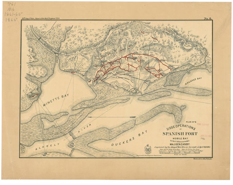
English: Description derived from published bibliography. Detailed map showing entrenchments, number, type, and position of Federal guns, vegetation, drainage, roads, and relief by hachures. From 39th Cong., 1st Sess. [1866]-Report of the Chief Engineer, U.S.A. No. 8. This item is in the Map Collection of the Library of Virginia; please contact the Library's Archives Research Services department for more information. LC Civil War Maps (2nd ed.), 112 Available also through the Library of Congress web site as raster image. May 1969, source unknown; Oct 2003, Map Cataloging Team. Civil War project no.: lva00156. Conservation: Etherington Conservation Center, Aug. 2003. Digital image available: 15.5 x 20 in. Map accession no. 896 (1913). Previously filed as: 761 M6 1861-1865 1865. |
||
| Title | Siege operations at Spanish Fort, Mobile Bay, by the U.S. forces under Maj. Gen. Canby : captured by the Army of West Miss. on the night of April 8 & 9, 1865 | ||
| Shelf ID | G3974.S65S5 1866 .M3 | ||
| Date | |||
| Source | https://www.loc.gov/item/lva0000156/ | ||
| Author | Mcalester, Miles D.; Allen, C. J.; Palfrey, J. C. | ||
| Permission (Reusing this file) |
|
||
| Other versions |
|
||
| Location | United States · Alabama · Mobile Bay · Mobile Bay Fort · Spanish Fort | ||
| Part of | Military Battles And Campaigns · American Memory · Civil War Maps | ||
| Subject | Spanish Fort · Mobile Bay · Civil War · United States · Maps · Mobile Bay Fort (Ala.) · Spanish Fort (Ala.) · Alabama · History |


Licensing[edit]
|
This is a faithful photographic reproduction of a two-dimensional, public domain work of art. The work of art itself is in the public domain for the following reason:
The official position taken by the Wikimedia Foundation is that "faithful reproductions of two-dimensional public domain works of art are public domain".
This photographic reproduction is therefore also considered to be in the public domain in the United States. In other jurisdictions, re-use of this content may be restricted; see Reuse of PD-Art photographs for details. | ||||
File history
Click on a date/time to view the file as it appeared at that time.
| Date/Time | Thumbnail | Dimensions | User | Comment | |
|---|---|---|---|---|---|
| current | 14:21, 9 June 2018 |  | 6,131 × 4,851 (85.09 MB) | Fæ (talk | contribs) | LOC Maps https://www.loc.gov/item/lva0000156/ #9765 |
You cannot overwrite this file.
File usage on Commons
The following page uses this file: