File:Tanzania, administrative divisions. LOC 81692116.jpg
Jump to navigation
Jump to search

Size of this preview: 567 × 600 pixels. Other resolutions: 227 × 240 pixels | 454 × 480 pixels | 726 × 768 pixels | 968 × 1,024 pixels | 1,936 × 2,048 pixels | 3,133 × 3,315 pixels.
Original file (3,133 × 3,315 pixels, file size: 1.2 MB, MIME type: image/jpeg)
Captions
Captions
Add a one-line explanation of what this file represents
Summary
[edit]| Description |
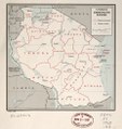
English: "59183 12-68." Available also through the Library of Congress Web site as a raster image. |
||
| Title | Tanzania, administrative divisions. | ||
| Shelf ID | G8441.F7 1968 .U5 | ||
| Date | |||
| Source | https://www.loc.gov/item/81692116/ | ||
| Author | United States. Central Intelligence Agency | ||
| Permission (Reusing this file) |
|
||
| Other versions |
|
||
| Location | Tanzania | ||
| Part of | American Memory · General Maps · Catalog · Geography And Map Division | ||
| Subject | Maps · Tanzania · Administrative And Political Divisions |

Licensing
[edit]
| This image is a work of a Central Intelligence Agency employee, taken or made as part of that person's official duties. As a Work of the United States Government, this image or media is in the public domain in the United States.
|

|
File history
Click on a date/time to view the file as it appeared at that time.
| Date/Time | Thumbnail | Dimensions | User | Comment | |
|---|---|---|---|---|---|
| current | 19:50, 9 May 2018 | | 3,133 × 3,315 (1.2 MB) | Fæ (talk | contribs) | LOC Maps https://www.loc.gov/item/81692116/ #54 |
You cannot overwrite this file.
File usage on Commons
The following page uses this file:
File usage on other wikis
The following other wikis use this file:
- Usage on sw.wikipedia.org