File:The harbor of Annapolis LOC 2008625101.tif
Jump to navigation
Jump to search

Size of this JPG preview of this TIF file: 714 × 600 pixels. Other resolutions: 286 × 240 pixels | 572 × 480 pixels | 914 × 768 pixels | 1,219 × 1,024 pixels | 2,438 × 2,048 pixels | 5,766 × 4,843 pixels.
Original file (5,766 × 4,843 pixels, file size: 79.89 MB, MIME type: image/tiff)
Captions
Captions
Add a one-line explanation of what this file represents
Summary[edit]
| Description |
English: Scale 1:60,000. Triangulation by James Ferguson and Ferd. H. Gerdes, assistants ; the hydrography under the direction of George M. Bache, lieutenant U.S. Navy ; typography by F.H. Gerdes, assistant. Relief shown by hachures. Depths shown by contours and soundings. Covers Annapolis region including Severn River and adjacent part of Chesapeake Bay. Available also through the Library of Congress Web site as a raster image. Includes sailing information and 4 coastal panoramas. AACR2: 110; 650/1; 650/2; 700/1; 700/2; 700/3; 700/4 |
||
| Title | The harbor of Annapolis | ||
| Shelf ID | G3844.A6P5 1846 .U5 | ||
| Date | |||
| Source | https://www.loc.gov/item/2008625101/ | ||
| Author | United States Coast Survey; Bache, A. D. (Alexander Dallas); Cutts, R. D. (Richard Dominicus); Ferguson, James; Gerdes, F. H. | ||
| Permission (Reusing this file) |
|
||
| Other versions |
|
||
| Location | United States · Annapolis Region · Annapolis · Maryland | ||
| Part of | American Memory · Catalog · Transportation And Communication · Geography And Map Division | ||
| Subject | Annapolis Region · Annapolis · Nautical Charts · Facsimiles · United States · Maps · Maryland · Harbors |


Licensing[edit]
|
This is a faithful photographic reproduction of a two-dimensional, public domain work of art. The work of art itself is in the public domain for the following reason:
The official position taken by the Wikimedia Foundation is that "faithful reproductions of two-dimensional public domain works of art are public domain".
This photographic reproduction is therefore also considered to be in the public domain in the United States. In other jurisdictions, re-use of this content may be restricted; see Reuse of PD-Art photographs for details. | ||||
File history
Click on a date/time to view the file as it appeared at that time.
| Date/Time | Thumbnail | Dimensions | User | Comment | |
|---|---|---|---|---|---|
| current | 22:15, 9 June 2018 | 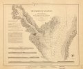 | 5,766 × 4,843 (79.89 MB) | Fæ (talk | contribs) | LOC Maps https://www.loc.gov/item/2008625101/ #25206 |
You cannot overwrite this file.
File usage on Commons
The following page uses this file: