File:Tour de France 2015 map-fr.svg
Jump to navigation
Jump to search

Size of this PNG preview of this SVG file: 498 × 600 pixels. Other resolutions: 199 × 240 pixels | 399 × 480 pixels | 638 × 768 pixels | 850 × 1,024 pixels | 1,701 × 2,048 pixels | 1,225 × 1,475 pixels.
Original file (SVG file, nominally 1,225 × 1,475 pixels, file size: 1.85 MB)
Captions
Captions
Add a one-line explanation of what this file represents
Summary[edit]
| Description |
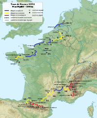
English: Roadmap of Tour de France 2015. Français : Carte du tracé du Tour de France 2015. |
||
| Date | |||
| Source |
|
||
| Author | Sémhur (talk) | ||
| Other versions |
| ||
| Attribution (required by the license) | © Sémhur / Wikimedia Commons / | ||
| SVG | W3C-validity not checked.
|
||
| Graphic Lab |

| Object location | | View this and other nearby images on: OpenStreetMap |
|---|
Licensing[edit]
I, the copyright holder of this work, hereby publish it under the following licenses:
| Copyleft: This work of art is free; you can redistribute it and/or modify it according to terms of the Free Art License. You will find a specimen of this license on the Copyleft Attitude site as well as on other sites. |
This file is licensed under the Creative Commons Attribution-Share Alike 4.0 International, 3.0 Unported, 2.5 Generic, 2.0 Generic and 1.0 Generic license.
- You are free:
- to share – to copy, distribute and transmit the work
- to remix – to adapt the work
- Under the following conditions:
- attribution – You must give appropriate credit, provide a link to the license, and indicate if changes were made. You may do so in any reasonable manner, but not in any way that suggests the licensor endorses you or your use.
- share alike – If you remix, transform, or build upon the material, you must distribute your contributions under the same or compatible license as the original.
You may select the license of your choice.
File history
Click on a date/time to view the file as it appeared at that time.
| Date/Time | Thumbnail | Dimensions | User | Comment | |
|---|---|---|---|---|---|
| current | 18:33, 12 August 2015 | | 1,225 × 1,475 (1.85 MB) | Sémhur (talk | contribs) | L'étape 4 est en accidentée (et non plus plaine), l'étape 10 aussi en accidentée (et non montagne) et l’étape 13 encore en accidentée (et non en plaine). Cf. page 12 du règlement (http://www.letour.fr/le-tour/2015/docs/TDF15_Reglement-BD.pdf) |
| 09:55, 19 July 2015 |  | 1,225 × 1,475 (1.85 MB) | Sémhur (talk | contribs) | 17 => 20 | |
| 20:53, 8 April 2015 |  | 1,225 × 1,475 (1.85 MB) | Sémhur (talk | contribs) | == {{int:filedesc}} == {{Information |Description={{Multilingual description |en= Roadmap of Tour de France 2015. |fr= Carte du tracé du Tour de France 2015. }} |Source= * [[:File:Fond de carte T... |
You cannot overwrite this file.
File usage on Commons
The following 4 pages use this file:
File usage on other wikis
The following other wikis use this file:
- Usage on cy.wikipedia.org
- Usage on de.wikipedia.org
- Usage on fi.wikipedia.org
- Usage on fr.wikipedia.org
- Usage on hr.wikipedia.org
- Usage on ie.wikipedia.org
- Usage on it.wikipedia.org
- Usage on ja.wikipedia.org
- Usage on nl.wikipedia.org
- Usage on sv.wikipedia.org