File:Tram map of Braila.xcf

Original file (691 × 1,059 pixels, file size: 852 KB, MIME type: image/x-xcf)
Captions
Captions
|
|
Summary
[edit]| Description |
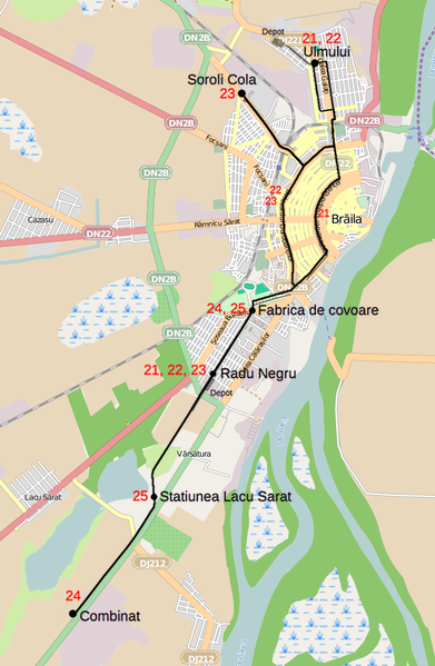
English: Tramway network of Brăila, Romania Deutsch: Topographischer Netzplan des Straßenbahnnetzes in Brăila, Rumänien |
|||
| Date | ||||
| Source | openstreetmap.org | |||
| Creator |
OpenStreetMap contributors |
|||
| Permission (Reusing this file) |
OpenStreetMap data is available under the Open Database License (details). Map tiles are licensed under the Creative Commons Attribution-ShareAlike 2.0 license (CC-BY-SA 2.0).
This file is licensed under the Creative Commons Attribution-Share Alike 2.0 Generic license.
|
|||
| Georeferencing | If inappropriate please set warp_status = skip to hide. |
File history
Click on a date/time to view the file as it appeared at that time.
| Date/Time | Thumbnail | Dimensions | User | Comment | |
|---|---|---|---|---|---|
| current | 12:33, 12 January 2013 |  | 691 × 1,059 (852 KB) | Bürgerentscheid (talk | contribs) | == {{int:filedesc}} == {{Information |Description=Tramway network of Braila |Date=2013-01-11 |Author= Bürgerentscheid |Source= Openstreetmap |Permission= |other_versions=[[File:Tram map of Braila.png|thumb|left|Correctly rend... |
You cannot overwrite this file.
File usage on Commons
The following page uses this file:
File usage on other wikis
The following other wikis use this file:
- Usage on de.wikipedia.org
- Usage on fr.wikipedia.org
- Usage on it.wikipedia.org
- Usage on ja.wikipedia.org
- Usage on pl.wikipedia.org
- Usage on ro.wikipedia.org
- Usage on www.wikidata.org