File:WW2 Holocaust Europe map-fr.svg
Jump to navigation
Jump to search

Size of this PNG preview of this SVG file: 721 × 600 pixels. Other resolutions: 289 × 240 pixels | 577 × 480 pixels | 923 × 768 pixels | 1,231 × 1,024 pixels | 2,461 × 2,048 pixels | 1,310 × 1,090 pixels.
Original file (SVG file, nominally 1,310 × 1,090 pixels, file size: 841 KB)
Captions
Captions
Add a one-line explanation of what this file represents
Summary[edit]
| Description |
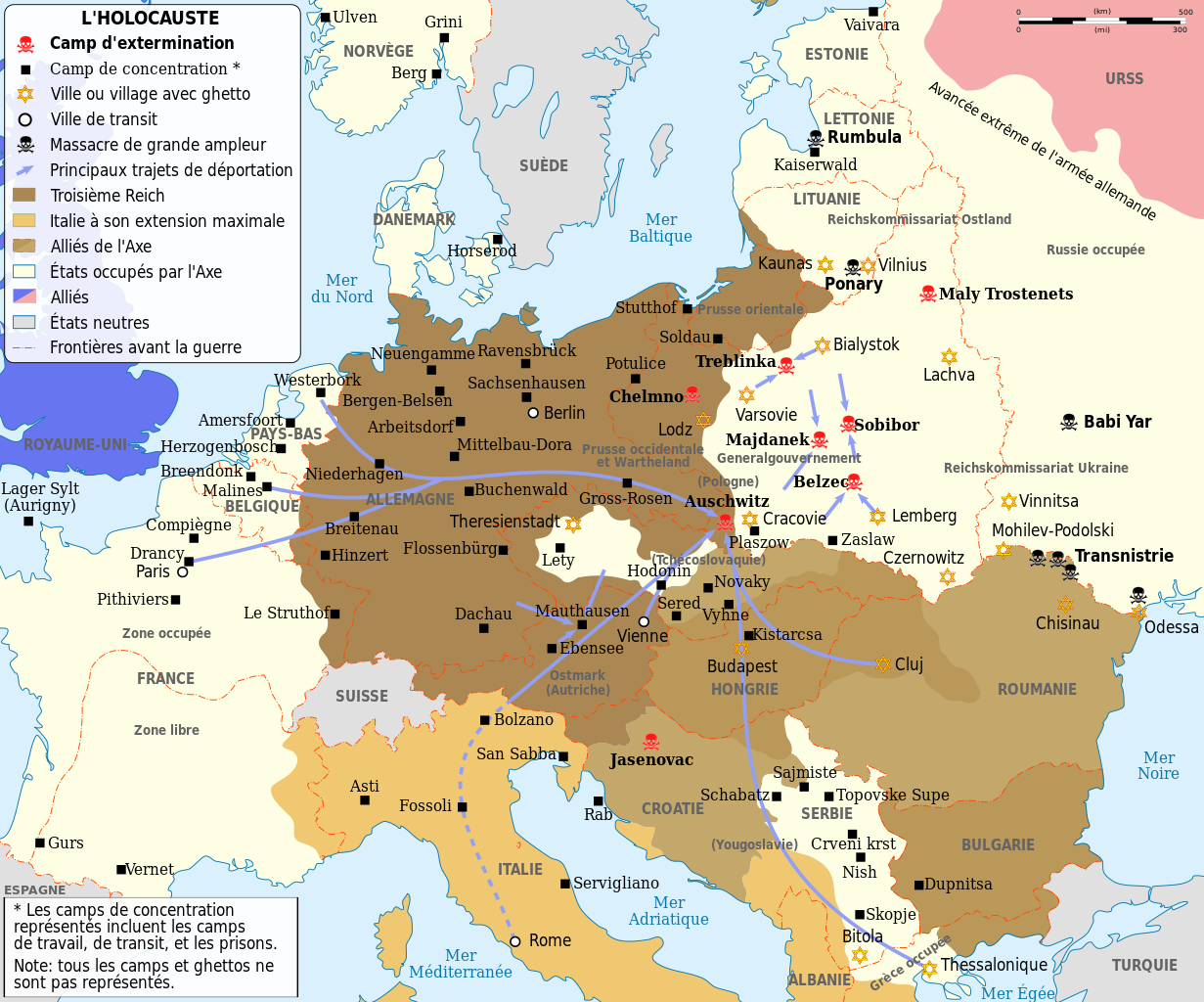
English: Map of the Holocaust in Europe during World War II, 1939-1945. This map shows all extermination camps (or death camps), most major concentration camps, labor camps, prison camps, ghettos, major deportation routes and major massacre sites.
Français : Carte de la Shoah en Europe lors de la Seconde Guerre mondiale (1939-1945). Cette carte montre tous les camps d'extermination (ou « camps de la mort ») et la plupart des principaux camps de concentration, de travail forcé, prisons, itinéraires de déportation et lieux de massacres.
Català: Mapa de L'Holocaust a Europa durant la Segona Guerra Mundial, 1939-1945.
|
||||
| Date | (UTC) | ||||
| Source | |||||
| Author |
|
||||
| Other versions |
[]
Derivative works of this file:
| ||||
| Attribution (required by the license) | © Sémhur / Wikimedia Commons / | ||||
| SVG |
|
||||
| Graphic Lab |


.png)


.png)


| Camera location | | View this and other nearby images on: OpenStreetMap |
|---|
Licensing[edit]
I, the copyright holder of this work, hereby publish it under the following licenses:
| Copyleft: This work of art is free; you can redistribute it and/or modify it according to terms of the Free Art License. You will find a specimen of this license on the Copyleft Attitude site as well as on other sites. |
This file is licensed under the Creative Commons Attribution-Share Alike 4.0 International, 3.0 Unported, 2.5 Generic, 2.0 Generic and 1.0 Generic license.
- You are free:
- to share – to copy, distribute and transmit the work
- to remix – to adapt the work
- Under the following conditions:
- attribution – You must give appropriate credit, provide a link to the license, and indicate if changes were made. You may do so in any reasonable manner, but not in any way that suggests the licensor endorses you or your use.
- share alike – If you remix, transform, or build upon the material, you must distribute your contributions under the same or compatible license as the original.
You may select the license of your choice.
Original upload log[edit]
This image is a derivative work of the following images:
- File:WW2-Holocaust-Europe.png licensed with Cc-by-3.0
- 2007-12-20T03:41:38Z Dna-webmaster 1310x1090 (845818 Bytes) new version without "Axis cooperating" in legend
- 2007-12-20T02:00:30Z Dna-webmaster 1310x1090 (844034 Bytes) Now entire West Prussia and Wartheland is included in the Third Reich
- 2007-12-19T16:42:15Z Dna-webmaster 1310x1090 (847461 Bytes) still not Da Vinci, but errors have been corrected (Germany borders West/East), West & East Prussia borders/coloring and Poland General Government corrected borders.
- 2007-12-17T10:46:28Z Dna-webmaster 1310x1090 (844633 Bytes) new map with 1942 borders, not Da Vinci, but here it goes...
- 2007-10-19T13:32:25Z Dna-webmaster 1310x1090 (784727 Bytes) and another update
- 2007-10-19T12:21:52Z Dna-webmaster 1310x1090 (789383 Bytes) quick fix
- 2007-10-19T12:11:07Z Dna-webmaster 1310x1090 (789413 Bytes) {{Information |Description=Map of the Holocaust in Europe during World War II, 1939-1945. This map shows all extermination camps (or ''death camps''), most major concentration camps, work camps, prison camps, ghettos, major
Uploaded with derivativeFX
File history
Click on a date/time to view the file as it appeared at that time.
| Date/Time | Thumbnail | Dimensions | User | Comment | |
|---|---|---|---|---|---|
| current | 15:24, 18 February 2024 | | 1,310 × 1,090 (841 KB) | Ispanas (talk | contribs) | File uploaded using svgtranslate tool (https://svgtranslate.toolforge.org/). Added translation for lt. |
| 13:30, 18 February 2024 |  | 1,310 × 1,090 (841 KB) | Ispanas (talk | contribs) | File uploaded using svgtranslate tool (https://svgtranslate.toolforge.org/). Added translation for lt. | |
| 07:20, 22 September 2023 |  | 1,310 × 1,090 (841 KB) | EnjolrasXXI (talk | contribs) | File uploaded using svgtranslate tool (https://svgtranslate.toolforge.org/). Added translation for ca. | |
| 21:25, 27 August 2023 |  | 1,310 × 1,090 (733 KB) | Tholme (talk | contribs) | Reverted to version as of 14:45, 28 February 2023 (UTC) | |
| 21:24, 27 August 2023 |  | 1,310 × 1,090 (490 KB) | Tholme (talk | contribs) | Reverted to version as of 14:47, 3 June 2021 (UTC) | |
| 14:45, 28 February 2023 |  | 1,310 × 1,090 (733 KB) | Andrei Stroe (talk | contribs) | File uploaded using svgtranslate tool (https://svgtranslate.toolforge.org/). Added translation for ro. | |
| 19:26, 29 October 2022 |  | 1,310 × 1,090 (625 KB) | Ispanas (talk | contribs) | File uploaded using svgtranslate tool (https://svgtranslate.toolforge.org/). Added translation for lt. | |
| 07:32, 13 September 2021 |  | 1,310 × 1,090 (490 KB) | BIG DADDY Dunkleosteus (talk | contribs) | Reverted to version as of 14:47, 3 June 2021 (UTC) | |
| 07:31, 13 September 2021 |  | 1,310 × 1,090 (555 KB) | BIG DADDY Dunkleosteus (talk | contribs) | File uploaded using svgtranslate tool (https://svgtranslate.toolforge.org/). Added translation for en. | |
| 14:47, 3 June 2021 |  | 1,310 × 1,090 (490 KB) | Tholme (talk | contribs) | remove another nested tspan |
You cannot overwrite this file.
File usage on Commons
The following 44 pages use this file:
- Atlas of World War II
- User:Magog the Ogre/Maps of conflicts/2016 August
- User:Magog the Ogre/Maps of conflicts/2021 June
- User:Magog the Ogre/Maps of conflicts/2021 September
- User:Magog the Ogre/Maps of conflicts/2022 October
- User:Magog the Ogre/Maps of conflicts/2023 August
- User:Magog the Ogre/Maps of conflicts/2023 February
- User:Magog the Ogre/Maps of conflicts/2023 September
- User:Magog the Ogre/Maps of conflicts/2024 February
- User:Magog the Ogre/Multilingual legend/2021 June 1-10
- User:Magog the Ogre/Multilingual legend/2021 September 11-20
- User:Magog the Ogre/Multilingual legend/2022 October 21-31
- User:Magog the Ogre/Multilingual legend/2023 August 27-31
- User:Magog the Ogre/Multilingual legend/2023 February 19-28
- User:Magog the Ogre/Multilingual legend/2023 September 21-25
- User:Magog the Ogre/Multilingual legend/2024 February 15-19
- File:EntenteDeLosBalcanes.svg
- File:PequeñaEntente.svg
- File:WW2-Holocaust-Europe-2007Borders.png
- File:WW2-Holocaust-Europe-2007Borders DE.png
- File:WW2-Holocaust-Europe-he.png
- File:WW2-Holocaust-Europe.png
- File:WW2-Holocaust-Europe (cropped).png
- File:WW2-Holocaust-Europe DE.png
- File:WW2-Holocaust-Europe DE 2.png
- File:WW2-Holocaust-Europe blank.png
- File:WW2-Holocaust-Poland-ru.png
- File:WW2-Holocaust-Poland-ukr.jpg
- File:WW2-Holocaust-Poland.PNG
- File:WW2-Holocaust-Poland (Français).png
- File:WW2-Holocaust-Poland (without comment).png
- File:WW2-Holocaust-Poland big legend.PNG
- File:WW2-Zagłada-Żydów-Polska.png
- File:WW2 Holocaust Europe N-E map-fr.svg
- File:WW2 Holocaust Europe map-blank.svg
- File:WW2 Holocaust Europe map-de.png
- File:WW2 Holocaust Europe map-es.svg
- File:WW2 Holocaust Europe map-fr.svg
- File:WW2 Holocaust Europe map-it.svg
- File:WW2 Holocaust Europe map-pt.svg
- File:WW2 Holocaust Europe map-zh-hans.svg
- File:WW2 Holocaust Poland map-fr.svg
- File:Холокост в Европе.png
- Template:Other versions/WW2 Holocaust Europe map
.png)
File usage on other wikis
The following other wikis use this file:
- Usage on ca.wikipedia.org
- Usage on de.wikipedia.org
- Usage on en.wikipedia.org
- Usage on fr.wikipedia.org
- Années 1940
- Liste des camps de concentration nazis
- Wikipédia:Atelier graphique/Cartes/Archives/mai 2009
- Shoah
- Convois de la déportation des Juifs de France
- Convois de la déportation des Juifs de Belgique
- Modèle:Palette Camps nazis par type et par pays
- Auschwitz II
- Shoah en France
- Camp de concentration de Potulitz
- Trains de la Shoah
- Ghetto de Białystok
- Ghetto de Kielce
- Camp de concentration de Senftenberg
- Camp de concentration de Mißler
- Utilisateur:Berdea/Convois de la déportation des Juifs de France
- Usage on fr.wikiversity.org
- Usage on fy.wikipedia.org
- Usage on he.wikipedia.org
- Usage on io.wikipedia.org
- Usage on it.wikipedia.org
- Usage on it.wikiquote.org
- Usage on lt.wikipedia.org
- Usage on no.wikipedia.org
- Usage on ro.wikipedia.org
- Usage on sh.wikipedia.org
- Usage on sr.wikipedia.org