File:Wien - Schottenkirche (1).JPG
Jump to navigation
Jump to search

Size of this preview: 800 × 551 pixels. Other resolutions: 320 × 220 pixels | 640 × 441 pixels | 1,024 × 705 pixels | 1,280 × 882 pixels | 2,560 × 1,763 pixels | 3,756 × 2,587 pixels.
Original file (3,756 × 2,587 pixels, file size: 7.94 MB, MIME type: image/jpeg)
Captions
Captions
Add a one-line explanation of what this file represents
Summary[edit]
| Description |
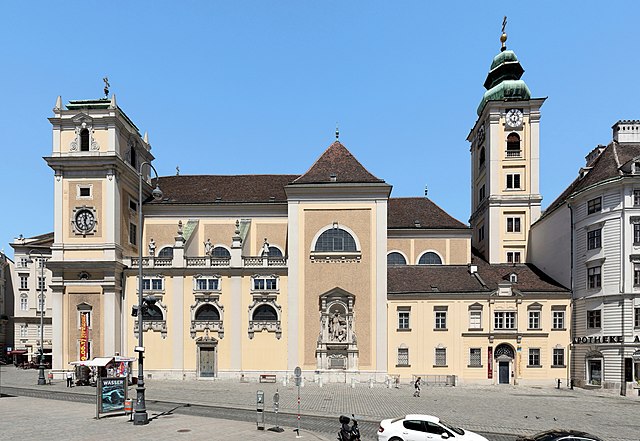
Deutsch: Südansicht der Schottenkirche im 1. Bezirk der österreichischen Bundeshauptstadt Wien mit dem Jasomirgott-Denkmal.
Die erste Stiftskirche wurde 1200 geweiht. Nachdem die "Schotten" das Kloster aufgaben und 1418 es die Melker Benediktiner übernahmen, erfolgte von 1446 bis 1449 der gotische Neubau des Chors und von 1449 bis circa 1454 die Erneuerung der Mittelschiff- und Querhausgewölbe sowie der Umbau der Westfassade. 1638 stürzte der Turm nach Blitzschlag ein. Dies wurde zum Anlass genommen, die Kirche in 10 Jahren gravierend umzubauen bzw. weitgehendst neu zu errichten und sie erhielt dabei im Groben ihr heutiges Erscheinungsbild. Das Jasomirgott-Denkmal wurde 1893 von dem Bildhauer Josef Breitner in Gedenken an Jasomirgott, Gründer des Schottenstiftes (1155), geschaffen.
|
|||
| Date | ||||
| Source | Own work | |||
| Author | C.Stadler/Bwag | |||
| Permission (Reusing this file) |
Deutsch: Hallo, du darfst mein Foto kostenlos nutzen, aber nenne mich bitte als Fotograf, beispielsweise „Foto: C.Stadler/Bwag“ oder © C.Stadler/Bwag; CC-BY-SA-4.0. Auf mehr Angaben bestehe ich nicht - im Gegensatz zu manch anderen, die die Vorgaben der unten angeführten Lizenzierung auf Punkt und Beistrich einfordern. English: Feel free to use my photos, but please mention me as the author like © C.Stadler/Bwag or © C.Stadler/Bwag; CC-BY-SA-4.0 (that's good enough) and if you want send me a message: bwag@gmx.net. |

| Camera location | | View this and other nearby images on: OpenStreetMap |
|---|
Licensing[edit]
I, the copyright holder of this work, hereby publish it under the following license:
This file is licensed under the Creative Commons Attribution-Share Alike 4.0 International license.
- You are free:
- to share – to copy, distribute and transmit the work
- to remix – to adapt the work
- Under the following conditions:
- attribution – You must give appropriate credit, provide a link to the license, and indicate if changes were made. You may do so in any reasonable manner, but not in any way that suggests the licensor endorses you or your use.
- share alike – If you remix, transform, or build upon the material, you must distribute your contributions under the same or compatible license as the original.
| Annotations | This image is annotated: View the annotations at Commons |

.JPG&action=edit§ion=1)
.JPG¶ms=048.211570_N_0016.365101_E_globe:Earth_type:camera_heading:0.00&language=en)
.JPG&action=edit§ion=2)
.JPG)
File history
Click on a date/time to view the file as it appeared at that time.
| Date/Time | Thumbnail | Dimensions | User | Comment | |
|---|---|---|---|---|---|
| current | 19:16, 30 May 2017 | | 3,756 × 2,587 (7.94 MB) | Bwag (talk | contribs) | p |
| 17:38, 30 May 2017 |  | 3,864 × 2,576 (7.93 MB) | Bwag (talk | contribs) | {{Information |Description= {{de|1=Südansicht der Schottenkirche im 1. Bezirk der österreichischen Bundeshauptstadt Wien mit dem Jasomirgott-Denkmal.<br/>.Die erste Stiftskirche wurde 1200 geweiht. Nachdem... |
You cannot overwrite this file.
File usage on Commons
The following 4 pages use this file:
.JPG)
File usage on other wikis
The following other wikis use this file:
- Usage on cs.wikipedia.org
- Usage on de.wikipedia.org
- Usage on de.wikivoyage.org
- Usage on en.wikipedia.org
- Usage on en.wikivoyage.org
- Usage on eo.wikipedia.org
- Usage on es.wikipedia.org
- Usage on fr.wikipedia.org
- Usage on id.wikipedia.org
- Usage on la.wikipedia.org
- Usage on ru.wikipedia.org
- Usage on www.wikidata.org
- Usage on zh.wikipedia.org
.JPG&oldid=784236949)