File:ElectoralCollege1984-Large.png
Aller à la navigation
Aller à la recherche
Taille de cet aperçu : 800 × 430 pixels. Autres résolutions : 320 × 172 pixels | 640 × 344 pixels | 1 182 × 635 pixels.
Fichier d’origine (1 182 × 635 pixels, taille du fichier : 163 kio, type MIME : image/png)
Légendes
Légendes
Ajoutez en une ligne la description de ce que représente ce fichier
| U.S. presidential election maps from the National Atlas of the United States |
| See also: SVG maps |
| 1789 · 1792 · 1796 · 1800 · 1804 · 1808 · 1812 · 1816 · 1820 · 1824 · 1828 · 1832 · 1836 · 1840 · 1844 · 1848 · 1852 · 1856 · 1860 · 1864 · 1868 · 1872 · 1876 · 1880 · 1884 · 1888 · 1892 · 1896 · 1900 · 1904 · 1908 · 1912 · 1916 · 1920 · 1924 · 1928 · 1932 · 1936 · 1940 · 1944 · 1948 · 1952 · 1956 · 1960 · 1964 · 1968 · 1972 · 1976 · 1980 · 1984 · 1988 · 1992 · 1996 · 2000 · 2004 |
Description[modifier]
| Description |
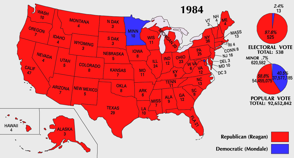
English: 1984 Electoral College Map |
|||
| Source | https://nationalmap.gov/small_scale/printable/elections.html | |||
| Auteur | Institut d'études géologiques des États-Unis | |||
| Autres versions |
|


Conditions d’utilisation[modifier]
Cette carte a été obtenue d'une édition du
National Atlas of the United States . Comme presque toutes les œuvres du gouvernement fédéral des États-Unis d'Amérique, les travaux du National Atlas sont placés dans le domaine public.Version en ligne : NationalAtlas.gov | Édition imprimée de 1970 : Library of Congress, Perry-Castañeda Library
|
Historique du fichier
Cliquer sur une date et heure pour voir le fichier tel qu'il était à ce moment-là.
| Date et heure | Vignette | Dimensions | Utilisateur | Commentaire | |
|---|---|---|---|---|---|
| actuel | 25 juillet 2007 à 10:20 | | 1 182 × 635 (163 kio) | Cardsplayer4life~commonswiki (d | contributions) | Reverted to earlier revision |
| 25 juillet 2007 à 09:32 |  | 1 182 × 635 (104 kio) | Joseph Solis in Australia~commonswiki (d | contributions) | {{PD-USGov-Atlas}} Category:1988 {{US presidential election maps}} | |
| 9 juillet 2007 à 01:46 |  | 1 182 × 635 (163 kio) | Cardsplayer4life~commonswiki (d | contributions) | {{PD-USGov-Atlas}} Category:1984 {{US presidential election maps}} | |
| 6 juillet 2007 à 09:36 |  | 1 182 × 635 (104 kio) | Joseph Solis in Australia~commonswiki (d | contributions) | {{PD-USGov-Atlas}} Category:1984 {{US presidential election maps}} | |
| 2 juillet 2007 à 02:28 |  | 1 182 × 635 (163 kio) | Cardsplayer4life~commonswiki (d | contributions) | {{PD-USGov-Atlas}} Category:1984 {{US presidential election maps}} | |
| 29 juin 2007 à 10:14 |  | 1 182 × 635 (104 kio) | Joseph Solis in Australia~commonswiki (d | contributions) | {{PD-USGov-Atlas}} Category:1984 {{US presidential election maps}} | |
| 21 juin 2007 à 21:07 |  | 1 182 × 635 (163 kio) | Cardsplayer4life~commonswiki (d | contributions) | {{PD-USGov-Atlas}} Category:1984 {{US presidential election maps}} | |
| 31 mai 2007 à 08:27 |  | 1 182 × 635 (104 kio) | Joseph Solis in Australia~commonswiki (d | contributions) | {{PD-USGov-Atlas}} Category:1984 {{US presidential election maps}} | |
| 25 mai 2006 à 20:06 |  | 1 182 × 635 (89 kio) | JP06035 (d | contributions) | switched colors | |
| 22 janvier 2006 à 16:08 |  | 1 182 × 635 (104 kio) | Red devil 666 (d | contributions) | {{PD-USGov-Atlas}} |
Vous ne pouvez pas remplacer ce fichier.
Utilisations locales du fichier
Les 3 pages suivantes utilisent ce fichier :
- U.S. election maps
- United States presidential election maps
- File:ElectoralCollege1984.png (redirection de fichier)
Utilisations du fichier sur d’autres wikis
Les autres wikis suivants utilisent ce fichier :
- Utilisation sur hu.wikipedia.org