File:Ireland.svg
Aller à la navigation
Aller à la recherche

Taille de cet aperçu PNG pour ce fichier SVG : 471 × 599 pixels. Autres résolutions : 188 × 240 pixels | 377 × 480 pixels | 603 × 768 pixels | 804 × 1 024 pixels | 1 609 × 2 048 pixels | 2 200 × 2 800 pixels.
Fichier d’origine (Fichier SVG, nominalement de 2 200 × 2 800 pixels, taille : 204 kio)
Légendes
Légendes
Ajoutez en une ligne la description de ce que représente ce fichier
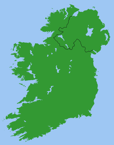
Ireland
Description[modifier]
Map of Ireland, with North-South boundary delimited.
SVG should be fairly easy to alter or expand. For example the following can all be achieved with one-line CSS changes:
- You can toggle the Northern Ireland border on/off or change its thickness
- You can change any of the colours
- You can draw a border around all the land to make it more distinct from the sea
- You can hide Northern Ireland or the Republic of Ireland.
You can also do any of the following just by changing or adding/removing a few lines of SVG code:
- Zoom in on Northern Ireland, the Munster shoreline, or any other area
- Remove all the small islands (e.g. for faster rendering)
- Add drop shadows (feGaussianBlur), textured ground (feTurbulance) or topography (feDisplacementMap + feSpecularLighting)
- Add cities and towns.
- Add rivers. Anyone care to do this?
Originally derived from Image:Lough-Neagh.svg.
Conditions d’utilisation[modifier]
| Moi, propriétaire des droits d’auteur sur cette œuvre, la place dans le domaine public. Ceci s'applique dans le monde entier. Dans certains pays, ceci peut ne pas être possible ; dans ce cas : J’accorde à toute personne le droit d’utiliser cette œuvre dans n’importe quel but, sans aucune condition, sauf celles requises par la loi. |
s]]
Historique du fichier
Cliquer sur une date et heure pour voir le fichier tel qu'il était à ce moment-là.
| Date et heure | Vignette | Dimensions | Utilisateur | Commentaire | |
|---|---|---|---|---|---|
| actuel | 13 mars 2007 à 21:49 | | 2 200 × 2 800 (204 kio) | Nickshanks (d | contributions) | increased default size, modified lough Erne |
| 13 mars 2007 à 21:19 |  | 550 × 700 (204 kio) | Nickshanks (d | contributions) | Map of Ireland, with North-South boundary delimited.<br/> SVG should be fairly easy to alter or expand. Northern Ireland is a separate group element<br/> Needs rivers adding. Anyone care to do this? Originally derived from Image:Lough-Neagh.svg. |
Vous ne pouvez pas remplacer ce fichier.
Utilisations locales du fichier
Les 4 pages suivantes utilisent ce fichier :
Utilisations du fichier sur d’autres wikis
Les autres wikis suivants utilisent ce fichier :
- Utilisation sur ca.wikipedia.org
- Utilisation sur en.wikipedia.org
- Michael Collins (Irish leader)
- Irish Boundary Commission
- Talk:Ireland (disambiguation)
- Repartition of Ireland
- User talk:BrownHairedGirl/Archive/Archive 012
- User:Roadnote/Ireland
- Wikipedia talk:WikiProject Eurovision/Archive 3
- List of Irish Presbyteries
- National symbols of Ireland, the Republic of Ireland and Northern Ireland
- Utilisation sur es.wikipedia.org
- Utilisation sur fa.wikipedia.org
- Utilisation sur fr.wikipedia.org
- Utilisation sur ga.wikipedia.org
- Utilisation sur it.wikipedia.org
- Utilisation sur no.wikipedia.org
- Utilisation sur pl.wikipedia.org
- Utilisation sur pt.wikipedia.org
- Utilisation sur ru.wikipedia.org
- Utilisation sur simple.wikipedia.org
- Utilisation sur sl.wikipedia.org
- Utilisation sur sv.wikipedia.org