File:World map of prehistoric human migrations.jpg
File originale (889 × 635 pixel, dimensione del file: 274 KB, tipo MIME: image/jpeg)
Didascalie
Didascalie

|
Questa immagine (categorizzazione automatica: biogeographical map) o tutte le immagini in questa categoria o galleria dovrebbero essere ricreate usando grafica vettoriale come file SVG. Questo offre diversi vantaggi: vedi Commons:Media for cleanup per maggiori informazioni. Se è disponibile una versione in formato SVG di questa immagine, per favore caricala. Dopo aver caricato un file SVG, sostituisci questo avviso con il template {{Vector version available|nome_immagine.svg}}.
|


Dettagli[modifica]
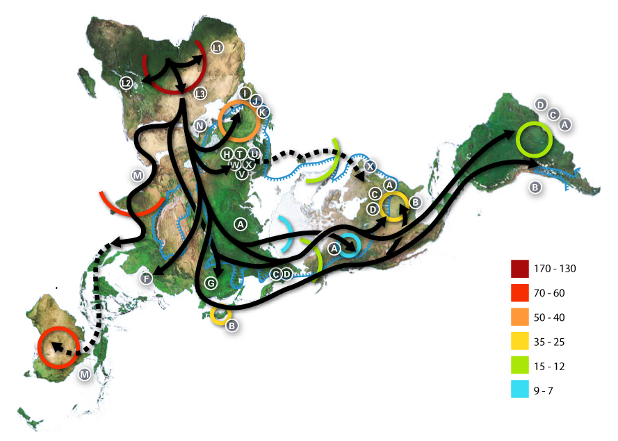
World map of human migrations, with the North Pole at center. Made in 2005.
Africa, harboring the start of the migration, is at the top left and South America at the far right. Migration patterns are based on studies of mitochondrial (matrilinear) DNA. Dashed lines are hypothetical migrations.
Numbers represent thousand years before present.
The blue line represents area covered in ice or tundra during the last great ice age.
The letters are the mitochondrial DNA haplogroups (pure motherly lineages); Haplogroups can be used to define genetic populations and are often geographically oriented. For example, the following are common divisions for mtDNA haplogroups:
- African: L, L1, L2, L3
- Near Eastern: J, N
- Southern European: J, K
- General European: H, V
- Northern European: T, U, X
- Asian: A, B, C, D, E, F, G (note: M is composed of C, D, E, and G)
- Native American: A, B, C, D, and sometimes X
- The letters I, J, K shown in Europe are apparently included by mistake, as they refer to Y-DNA haplogroups.
The dashed path for X, stopping in Iceland, gestures at the "Solutrean hypothesis", an idea discussed in the popular media at the time the map was made but mostly discredited since.
Data derivation[modifica]
- Image:Northern icesheet hg.png shows the region that was covered by ice or tundra in the last ice age
- All migration data based on mitomap.
- Geographic data from File:Last glacial vegetation map.png
- and adding the following data File:Ice Age Temperature.png we get this interesting result File:Human-migration-temperature.jpg
Licenses[modifica]

|
È permesso copiare, distribuire e/o modificare questo documento in base ai termini della GNU Free Documentation License, Versione 1.2 o successive pubblicata dalla Free Software Foundation; senza alcuna sezione non modificabile, senza testo di copertina e senza testo di quarta di copertina. Una copia della licenza è inclusa nella sezione intitolata Testo della GNU Free Documentation License. |
| Questo file è disponibile in base alla licenza Creative Commons Attribuzione-Condividi allo stesso modo 3.0 Unported | ||
| ||
| Questo tag di copyright è stato aggiunto nell'ambito dell'aggiornamento della licenza dei progetti Wikimedia. |
- Tu sei libero:
- di condividere – di copiare, distribuire e trasmettere quest'opera
- di modificare – di adattare l'opera
- Alle seguenti condizioni:
- attribuzione – Devi fornire i crediti appropriati, un collegamento alla licenza e indicare se sono state apportate modifiche. Puoi farlo in qualsiasi modo ragionevole, ma non in alcun modo che suggerisca che il licenziante approvi te o il tuo uso.
- condividi allo stesso modo – Se remixi, trasformi o sviluppi il materiale, devi distribuire i tuoi contributi in base alla stessa licenza o compatibile all'originale.
Cronologia del file
Fare clic su un gruppo data/ora per vedere il file come si presentava nel momento indicato.
| Data/Ora | Miniatura | Dimensioni | Utente | Commento | |
|---|---|---|---|---|---|
| attuale | 01:54, 2 lug 2015 | | 889 × 635 (274 KB) | Chronus (discussione | contributi) | Reverted to version as of 03:10, 22 May 2012 |
| 18:00, 24 giu 2015 |  | 632 × 889 (295 KB) | SteinsplitterBot (discussione | contributi) | Bot: Image rotated by 90° | |
| 03:10, 22 mag 2012 |  | 889 × 635 (274 KB) | 84user (discussione | contributi) | Reverted to version as of 19:10, 12 August 2005 | |
| 23:30, 20 mag 2012 |  | 632 × 889 (295 KB) | Rotatebot (discussione | contributi) | Bot: Image rotated by 90° | |
| 19:10, 12 ago 2005 |  | 889 × 635 (274 KB) | Avsa (discussione | contributi) | ||
| 21:05, 5 ago 2005 |  | 536 × 380 (80 KB) | Stevertigo (usurped) (discussione | contributi) | reupload with similar changes, but without compression/artifacts | |
| 21:00, 5 ago 2005 |  | 536 × 380 (30 KB) | Stevertigo (usurped) (discussione | contributi) | altered brightness contrast - black/brown blending was distracting in last version | |
| 20:30, 17 lug 2005 |  | 536 × 380 (110 KB) | Avsa (discussione | contributi) | ||
| 18:08, 16 lug 2005 |  | 745 × 380 (99 KB) | Avsa (discussione | contributi) | Map of human races migration, according to the mithocondrial dna. All data based on mitomap http://www.mitomap.org/WorldMigrations.pdf I ignored all data I could not understand (for example a dotted line, the +/- and the letters). If someone explains to | |
| 18:03, 16 lug 2005 |  | 745 × 380 (99 KB) | Avsa (discussione | contributi) | Map of human races migration, according to the mithocondrial dna. All data based on mitomap http://www.mitomap.org/WorldMigrations.pdf I ignored all data I could not understand (for example a dotted line, the +/- and the letters). If someone explains to |
Impossibile sovrascrivere questo file.
Utilizzo del file
Le seguenti 24 pagine usano questo file:
- Atlas of Africa
- Atlas of world history
- Homo sapiens
- Top 200 JPG images that should use vector graphics
- Top 200 biology images that should use vector graphics
- Top 200 map images that should use vector graphics
- User:Joaquín Salido Bello
- User:Zeupar
- Commons:Featured picture candidates/Image:Map-of-human-migrations.jpg
- Commons:Featured picture candidates/Log/December 2005
- Commons:Village pump/Archive/2016/10
- Commons:Wikimania Media Competition 2005/Maps and Diagrams
- File:Early migrations mercator.svg
- File:Map-of-human-migrations.jpg (reindirizzamento file)
- Commons:Wikimania Media Competition 2005/Maps and Diagrams
- Commons:Featured picture candidates/Log/December 2005
- Commons:Featured picture candidates/Image:Map-of-human-migrations.jpg
- Atlas of world history
- File talk:Human-migration-temperature.jpg
- Commons:Village pump/Archive/2016/10
- User:Joaquín Salido Bello
- File:Early migrations mercator.svg
- File talk:Human-migration-temperature.jpg
- Category:Out of Africa
Utilizzo globale del file
Anche i seguenti wiki usano questo file:
- Usato nelle seguenti pagine di af.wikipedia.org:
- Usato nelle seguenti pagine di ar.wikipedia.org:
- Usato nelle seguenti pagine di ba.wikipedia.org:
- Usato nelle seguenti pagine di bn.wikipedia.org:
- Usato nelle seguenti pagine di bs.wikipedia.org:
- Usato nelle seguenti pagine di bxr.wikipedia.org:
- Usato nelle seguenti pagine di ca.wikipedia.org:
- Usato nelle seguenti pagine di cs.wikipedia.org:
- Usato nelle seguenti pagine di da.wikipedia.org:
- Usato nelle seguenti pagine di de.wikipedia.org:
- Usato nelle seguenti pagine di de.wikinews.org:
- Usato nelle seguenti pagine di de.wiktionary.org:
- Usato nelle seguenti pagine di en.wikipedia.org:
- Human evolution
- Wildlife
- Dymaxion map
- Talk:Human migration
- User:Avsa
- User talk:Truthteller
- Wikipedia:Reference desk/Archives/July 2005 II
- Genealogical DNA test
- User talk:Brian0918/Archive 07
- Haplogroup
- Talk:Human/Archive 16
- Haplogroup N (mtDNA)
- Haplogroup A (mtDNA)
- Haplogroup C (mtDNA)
- Haplogroup L3
- Human genetic variation
- Haplogroup Y
- Talk:Black people/Archive 11
- Portal:Maps/Maps/Thematic
- Portal:Maps/Maps/Thematic/1
Visualizza l'utilizzo globale di questo file.
- Haplogroup J (mtDNA)
- Haplogroup H (mtDNA)
- Human mtDNA haplogroups
- Out of Africa maps
- Homo sapiens distribution maps
- Pleistocene
- Holocene life
- Maps with Fuller projection
- Haplogroup T (mtDNA)
- Haplogroup H (mtDNA) in Poland
- Phylogenetic tree of human populations
- Haplogroup L3 (mtDNA)
- Genetic studies on Oceanian populations