File:OrteliusWorldMap.jpeg
Aller à la navigation
Aller à la recherche
Taille de cet aperçu : 800 × 545 pixels. Autres résolutions : 320 × 218 pixels | 640 × 436 pixels | 1 024 × 697 pixels | 1 280 × 872 pixels | 2 560 × 1 744 pixels | 5 788 × 3 942 pixels.
Fichier d’origine (5 788 × 3 942 pixels, taille du fichier : 26,95 Mio, type MIME : image/jpeg)
Légendes
Légendes
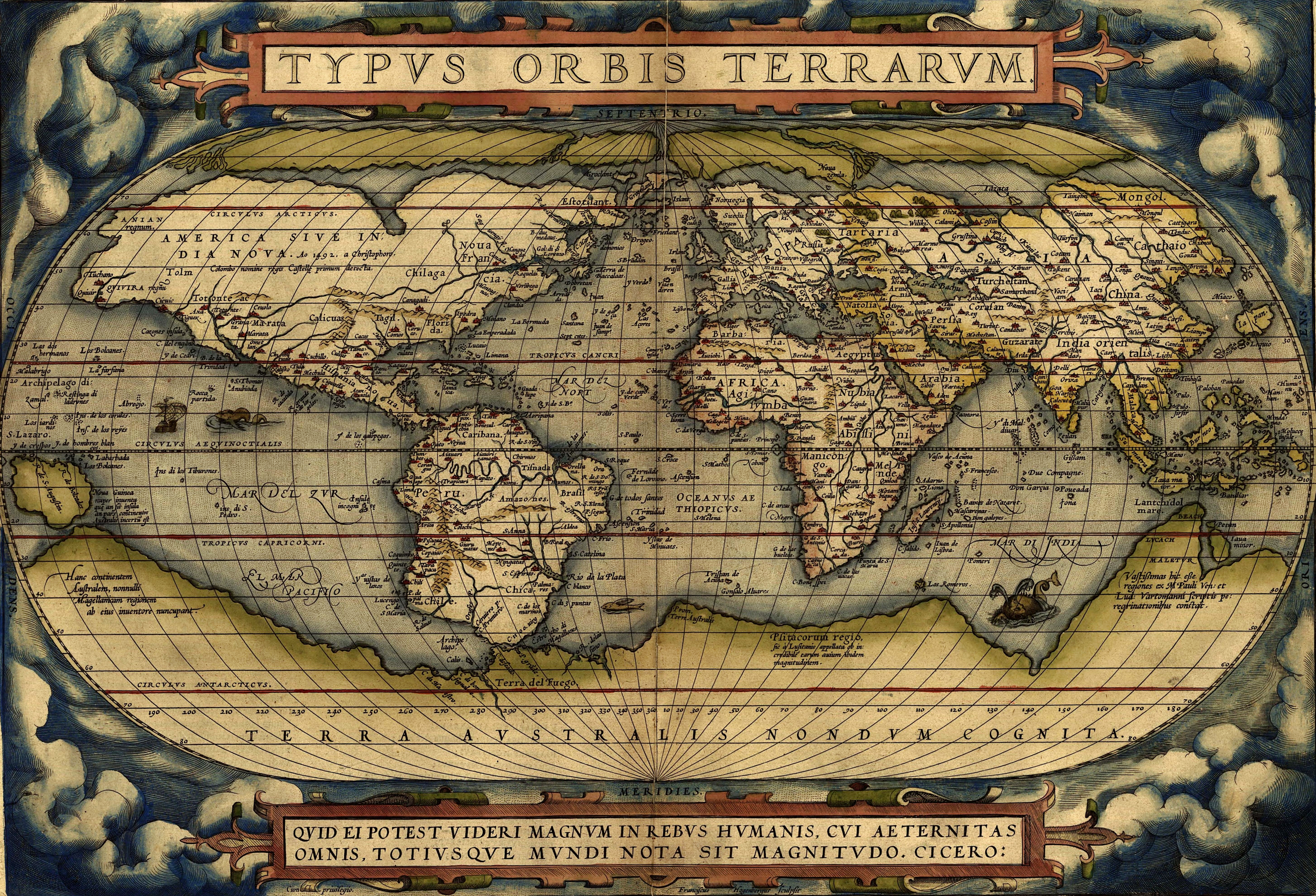
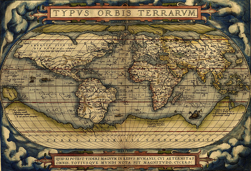
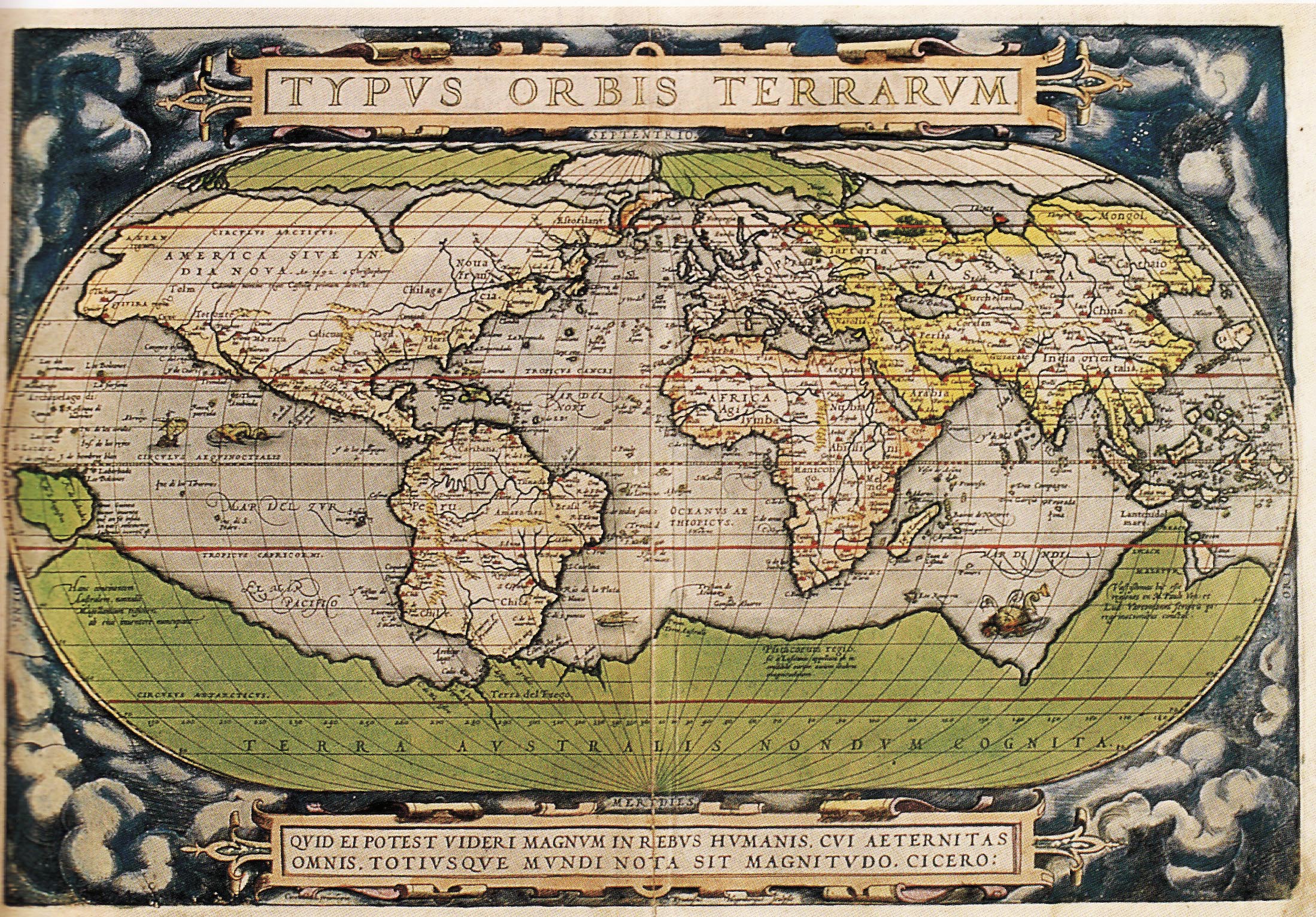
Carte du Monde d'Ortelius
Description[modifier]
| Description |
English: Ortelius world map 1570
Español: Mapa Mundial de Ortelius, 1570
Türkçe: Ortelius'un dünya haritası, 1570
עברית: מפת העולם מתוך אטלס אורטליוס |
|||||||||||||||||||||||
| Date | ||||||||||||||||||||||||
| Source | http://www.britishempire.co.uk/images4/ortelius1570maplarge.jpg | |||||||||||||||||||||||
| Auteur |
|
|||||||||||||||||||||||

Conditions d’utilisation[modifier]
|
Ceci est une reproduction photographique fidèle d'une œuvre d'art originale en deux dimensions. L'œuvre d'art elle-même est dans le domaine public pour la raison suivante :
La position officielle de la Fondation Wikimedia est que « les représentations fidèles des œuvres d'art du domaine public en deux dimensions sont dans le domaine public et les exigences contraires sont une attaque contre le concept même de domaine public ». Pour plus de détails, voir Commons:Quand utiliser le bandeau PD-Art.
Cette reproduction photographique est donc également considérée comme étant élevée dans le domaine public. Merci de noter qu'en fonction des lois locales, la réutilisation de ce contenu peut être interdite ou restreinte dans votre juridiction. Voyez Commons:Reuse of PD-Art photographs. | ||||
Historique du fichier
Cliquer sur une date et heure pour voir le fichier tel qu'il était à ce moment-là.
| Date et heure | Vignette | Dimensions | Utilisateur | Commentaire | |
|---|---|---|---|---|---|
| actuel | 1 février 2015 à 08:37 | | 5 788 × 3 942 (26,95 Mio) | Hello world (d | contributions) | new |
| 1 février 2015 à 08:30 |  | 2 198 × 1 532 (6,79 Mio) | Hello world (d | contributions) | new | |
| 1 février 2015 à 08:23 |  | 2 198 × 1 532 (6,79 Mio) | Hello world (d | contributions) | new | |
| 13 juin 2005 à 11:46 |  | 616 × 424 (100 kio) | ¡0-8-15! (d | contributions) | Ortelius world map 1570 {{PD-Old}} |
Vous ne pouvez pas remplacer ce fichier.
Utilisations locales du fichier
Plus de 100 pages utilisent ce fichier. La liste suivante affiche seulement les 100 premières pages qui utilisent ce fichier. Une liste complète est disponible.
- Facsimile atlas
- Maps of the world
- Old maps
- User:Kanchelskis/Atlante
- File:1570 Typus Ortelius mr.jpg
- File:1572 Typus Orbis Terrarum Ortelius.jpg
- Category:Geography
- Category:Geography by continent
- Category:Geography by country
- Category:Geography of Achaea
- Category:Geography of Anhui
- Category:Geography of Bavaria
- Category:Geography of Cantabria
- Category:Geography of Carinthia
- Category:Geography of Central Europe
- Category:Geography of Chukotka
- Category:Geography of Crimea
- Category:Geography of Dagestan
- Category:Geography of Eastern Europe
- Category:Geography of Friesland
- Category:Geography of Friuli-Venezia Giulia
- Category:Geography of Fujian
- Category:Geography of Gansu
- Category:Geography of Guangxi
- Category:Geography of Guizhou
- Category:Geography of Hainan
- Category:Geography of Hebei
- Category:Geography of Heilongjiang
- Category:Geography of Henan
- Category:Geography of Hubei
- Category:Geography of Indre-et-Loire
- Category:Geography of Inner Mongolia
- Category:Geography of Jiangxi
- Category:Geography of Kabardino-Balkaria
- Category:Geography of Kaliningrad Oblast
- Category:Geography of Karachay-Cherkessia
- Category:Geography of Karelia
- Category:Geography of Khakassia
- Category:Geography of Kirov Oblast
- Category:Geography of Komi
- Category:Geography of Krasnodar Krai
- Category:Geography of La Palma
- Category:Geography of Lower Saxony
- Category:Geography of Mecklenburg-Vorpommern
- Category:Geography of Mordovia
- Category:Geography of Moscow Oblast
- Category:Geography of Munich
- Category:Geography of Murmansk Oblast
- Category:Geography of Neuquén Province
- Category:Geography of Ningxia
- Category:Geography of Nordland
- Category:Geography of Northern Africa
- Category:Geography of Olsztyn
- Category:Geography of Oryol Oblast
- Category:Geography of Perm Krai
- Category:Geography of Philadelphia
- Category:Geography of Rajasthan
- Category:Geography of Rhineland-Palatinate
- Category:Geography of Rome
- Category:Geography of Rondônia
- Category:Geography of Rostov Oblast
- Category:Geography of Ryazan Oblast
- Category:Geography of Río Negro Province
- Category:Geography of Saarland
- Category:Geography of Sabah
- Category:Geography of Saint-Martin
- Category:Geography of Saint-Martin (France)
- Category:Geography of Salzburg (state)
- Category:Geography of Samara Oblast
- Category:Geography of San Francisco
- Category:Geography of Santa Cruz de La Palma
- Category:Geography of Sardinia
- Category:Geography of Saxony
- Category:Geography of Schleswig-Holstein
- Category:Geography of Seoul
- Category:Geography of Sergipe
- Category:Geography of Shaanxi
- Category:Geography of Shanxi
- Category:Geography of Sichuan
- Category:Geography of Soest, Germany
- Category:Geography of South Georgia and the South Sandwich Islands
- Category:Geography of Southeastern Europe
- Category:Geography of Spain by autonomous community
- Category:Geography of Styria
- Category:Geography of Switzerland by canton
- Category:Geography of Tenerife
- Category:Geography of Thun
- Category:Geography of Tocantins
- Category:Geography of Trentino
- Category:Geography of Trentino-South Tyrol
- Category:Geography of Ulyanovsk Oblast
- Category:Geography of Upper Austria
- Category:Geography of Vienna
- Category:Geography of Vorarlberg
- Category:Geography of Xinjiang
- Category:Geography of Yunnan
- Category:Geography of the British Overseas Territories
- Category:Geography of the Caribbean
- Category:Geography of the Region of Murcia
- Category:Geography of the canton of Lucerne
Voir plus de liens vers ce fichier.
Utilisations du fichier sur d’autres wikis
Les autres wikis suivants utilisent ce fichier :
- Utilisation sur af.wikipedia.org
- Utilisation sur ang.wikipedia.org
- Utilisation sur ar.wikipedia.org
- جغرافيا
- عصر الاستكشاف
- تاريخ أوروبا
- التاريخ البشري
- تاريخ القارة القطبية الجنوبية
- قالب:شريط جانبي تاريخ الجغرافيا
- الجغرافيا في عصر الحضارة الإسلامية
- قائمة البلدان من حيث عدد السكان لعام 1900م
- بوابة:المحيط الأطلسي/مقالة مختارة/أرشيف
- بوابة:المحيط الأطلسي/مقالة مختارة/2
- الجغرافيا اليونانية الرومانية
- تاريخ الأرجنتين
- جغرافيا تاريخية
- تيرا أستراليس
- ويكيبيديا:ويكيبيديا للمدارس/مرحبا/جغرافيا
- Utilisation sur arz.wikipedia.org
- Utilisation sur ast.wikipedia.org
- Utilisation sur az.wikipedia.org
- Utilisation sur ba.wikipedia.org
- Utilisation sur be-tarask.wikipedia.org
- Utilisation sur bg.wikipedia.org
- Utilisation sur bh.wikipedia.org
- Utilisation sur bn.wikipedia.org
- Utilisation sur br.wikipedia.org
- Utilisation sur ca.wikipedia.org
Voir davantage sur l’utilisation globale de ce fichier.