File:Stromness-Bay.jpg
Aller à la navigation
Aller à la recherche

Taille de cet aperçu : 800 × 493 pixels. Autres résolutions : 320 × 197 pixels | 640 × 394 pixels | 1 024 × 631 pixels | 1 280 × 789 pixels | 1 792 × 1 104 pixels.
Fichier d’origine (1 792 × 1 104 pixels, taille du fichier : 937 kio, type MIME : image/jpeg)
Légendes
Légendes
Ajoutez en une ligne la description de ce que représente ce fichier
Description[modifier]
- Description
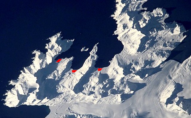
English: Satellite image of central South Georgia Island - Antarctic region.
- Stromness Bay: with Husvik, Stromness, and Leith Harbours; and peninsulas.
- Image
- Science and Analysis Laboratory, NASA-Johnson Space Center. "The Gateway to Astronaut Photography of Earth."
<http://eol.jsc.nasa.gov/scripts/sseop/QuickView.pl?directory=ESC&ID=ISS002-E-10079> (10/01/2007 15:24:24)
Source [1]
Cette image ou vidéo a été cataloguée par l’un des centres de la National Aeronautics and Space Administration (NASA) des États-Unis sous Photo ID : ISS002-E-10079.Ce bandeau n’indique rien sur le statut de l’œuvre au regard du droit d'auteur. Un bandeau de droit d’auteur est requis. Voir Commons:À propos des licences pour plus d’informations. Autres langues :
|
Conditions d’utilisation[modifier]
| Ce fichier provient de la NASA. Sauf exception, les documents créés par la NASA ne sont pas soumis à copyright. Pour plus d'informations, voir la politique de copyright de la NASA. | ||
 |
Attention :
|
| Annotations | Cette image est annotée : Voir les annotations sur Wikimedia Commons |
Historique du fichier
Cliquer sur une date et heure pour voir le fichier tel qu'il était à ce moment-là.
| Date et heure | Vignette | Dimensions | Utilisateur | Commentaire | |
|---|---|---|---|---|---|
| actuel | 30 septembre 2017 à 16:00 | | 1 792 × 1 104 (937 kio) | SteinsplitterBot (d | contributions) | Bot: Image rotated by 180° |
| 1 octobre 2007 à 13:57 |  | 1 805 × 1 113 (908 kio) | Apcbg (d | contributions) | Satellite image of central South Georgia Island: Stromness Bay with Husvik, Stromness, and Leith Harbour Image Science and Analysis Laboratory, NASA-Johnson Space Center. "The Gateway to Astronaut Photography of Earth." <http://eol.jsc.nasa.gov/scripts | |
| 1 octobre 2007 à 13:28 |  | 1 802 × 1 458 (1,16 Mio) | Apcbg (d | contributions) | Satellite image of central South Georgia Island: Stromness Bay with Husvik, Stromness, and Leith Harbour Image Science and Analysis Laboratory, NASA-Johnson Space Center. "The Gateway to Astronaut Photography of Earth." <http://eol.jsc.nasa.gov/scripts |
Vous ne pouvez pas remplacer ce fichier.
Utilisations locales du fichier
La page suivante utilise ce fichier :
Utilisations du fichier sur d’autres wikis
Les autres wikis suivants utilisent ce fichier :
- Utilisation sur ang.wikipedia.org
- Utilisation sur ceb.wikipedia.org
- Utilisation sur da.wikipedia.org
- Utilisation sur de.wikipedia.org
- Utilisation sur en.wikipedia.org
- Utilisation sur es.wikipedia.org
- Utilisation sur fr.wikipedia.org
- Utilisation sur hu.wikipedia.org
- Utilisation sur it.wikipedia.org
- Utilisation sur nl.wikipedia.org
- Utilisation sur nn.wikipedia.org
- Utilisation sur no.wikipedia.org
- Utilisation sur pt.wikipedia.org
- Utilisation sur www.wikidata.org
- Utilisation sur zh.wikipedia.org