File:Vesuve-NASA.jpg
Jump to navigation
Jump to search

Size of this preview: 601 × 600 pixels. Other resolutions: 240 × 240 pixels | 481 × 480 pixels | 770 × 768 pixels | 1,026 × 1,024 pixels | 2,052 × 2,048 pixels | 4,089 × 4,081 pixels.
Original file (4,089 × 4,081 pixels, file size: 4.63 MB, MIME type: image/jpeg)
Captions
Captions
Add a one-line explanation of what this file represents
Summary[edit]
| Description |
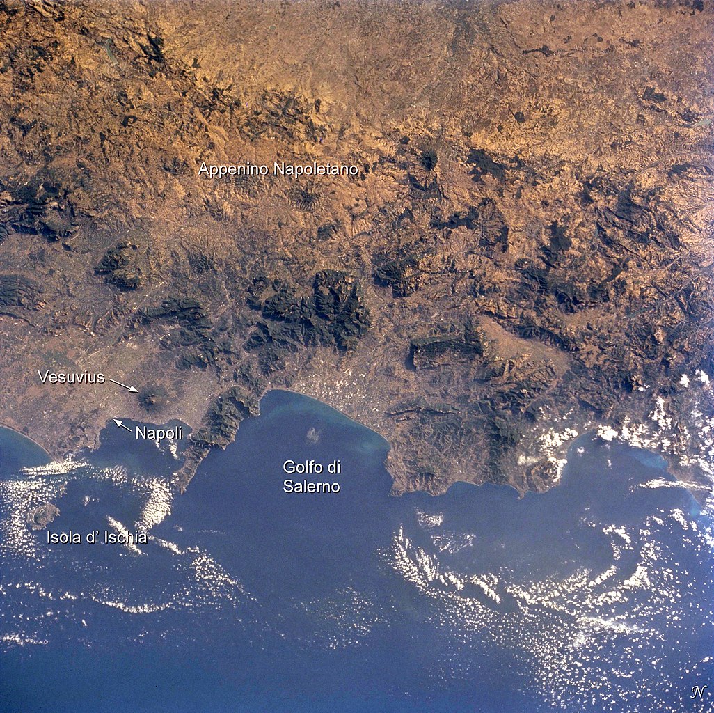
English: Photo of the bay of Naples and the Vesuvius vulcano, taken by Space Shuttle astronauts
Français : Photo satellite de la baie de Naples avec le Vésuve |
| Date | |
| Source | Earth Sciences and Image Analysis, NASA-Johnson Space Center. 16 Apr. 2004. "Earth from Space - Image Information." http://earth.jsc.nasa.gov/sseop/EFS/photoinfo.pl?PHOTO=STS104-710-60 |
| Author |
NASA |
This image or video was catalogued by one of the centers of the United States National Aeronautics and Space Administration (NASA) under Photo ID: STS104-710-60. This tag does not indicate the copyright status of the attached work. A normal copyright tag is still required. See Commons:Licensing. Other languages:
|
Licensing[edit]
This file is in the public domain in the United States because it was created by the Image Science & Analysis Laboratory, of the NASA Johnson Space Center. NASA copyright policy states that "NASA material is not protected by copyright unless noted". (NASA media use guidelines or Conditions of Use of Astronaut Photographs).
Photo source: STS104-710-60.
|
Original upload log[edit]
(All user names refer to fr.wikipedia)
- 2004-08-05 20:18 Nataraja 540×540×8 (100321 bytes) photo satellite de la baie avec le Vésuve
File history
Click on a date/time to view the file as it appeared at that time.
| Date/Time | Thumbnail | Dimensions | User | Comment | |
|---|---|---|---|---|---|
| current | 17:14, 2 December 2014 | | 4,089 × 4,081 (4.63 MB) | Ras67 (talk | contribs) | with captions |
| 17:09, 2 December 2014 |  | 4,089 × 4,081 (4.55 MB) | Ras67 (talk | contribs) | high resolution without captions | |
| 08:29, 6 February 2007 |  | 540 × 540 (98 KB) | Bilou~commonswiki (talk | contribs) | {{Information |Description=photo satellite de la baie de Naples avec le Vésuve |Source=Earth Sciences and Image Analysis, NASA-Johnson Space Center. 16 Apr. 2004. "Earth from Space - Image Information." http://earth.jsc.nasa.gov/sseop/EFS/photoinfo.pl?PH |
You cannot overwrite this file.
File usage on Commons
There are no pages that use this file.
File usage on other wikis
The following other wikis use this file:
- Usage on ca.wikipedia.org
- Usage on de.wikipedia.org
- Usage on eo.wikipedia.org
- Usage on fr.wikipedia.org
- Usage on nl.wikipedia.org
- Usage on rm.wikipedia.org
Metadata
Categories:
- Earth photography during STS-104
- Satellite pictures of Vesuvius
- Satellite pictures of the Gulf of Naples
- Satellite pictures of Campi Flegrei
- Satellite pictures of Ischia (island)
- Satellite pictures of volcanoes in Italy in 2001
- Weather and climate of Campania
- Vesuvius in 2001
- Campi Flegrei in 2001
- Volcanism of Europe in 2001