Mapas del Virreinato del Perú
Ir a la navegación
Ir a la búsqueda
-
 1635
1635 -
 1647
1647 -
 1652
1652 -
 1683
1683 -
 1683
1683 -
 1720
1720 -
 1750
1750 -
 1750
1750 -
 1780
1780 -
 1750
1750 -
 1770
1770


Mapas
- 1574 - Cartógrafo : Didaco Mendezio (Diego Méndez). Nombre del mapa : Peruviae Auriferae Regionis Typus.</samall>
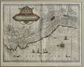
- 1635 – Cartógrafo : Guiljelmus Blaeuw (1571-1638). Nombre del mapa : Peru. Mar del Zur. 300 ejemplares.
- 1647 – Cartógrafo : Apud Ioannem Ianffonium. (1588-1664). Nombre del Mapa : Peru. Mar del Zur. 1
- ca. 1720 – Cartógrafo : Hermann Moll. (16xx-1732). Nombre del mapa : Peru and the Amazones. Of the Kingdom of Peru.
- ca.1750 – Cartógrafo : Eman Bowen. Nombre del mapa : A new and accurate map of Peru and the country of the Amazones. Drawn from the most authentic French Maps & Co. and Regulated by Astronomical observations. Certificado : Antique map of Peru by Emanuel Bowen. Engraved to George II of England and Louis XV of France. He died in 1767 and his business was carried on by his son Thomas.
- ca.1750 – Cartógrafo : Benard Direxit. Nombre del mapa : Carte du Pérou. Pour l’Histoire Générale des Voyages. Tome 11. in 8. Page 376.
- ca.1770. Cartógrafo : Jonghe. Nombre del mapa : America. Certificado : "Certificate of origin: Originalt kobberstikk, Händkolorert, Jonghe ca. 1770, Damms Antikvariat A/S (Claes Nyeggard), Established 1843".
- ca. 1779 - Cartógrafo : desconocido. Nombre del mapa : Carte du Pérou avec une partie des pays qui en sont à l'Est; Liv. VII. X. Lámina 30. En blanco y negro solamente. Similar al descrito inmediatamente después.
- ca. 1780 – Cartógrafo : Rigobert Bonne, (1727-1795) Ingénieur, Hydrographe de la Marine. Nombre del mapa : Carte du Pérou avec une partie des pays qui en sont à l’Est. Liv. VII. X. Lámina 30.
- ca. 1780. Cartógrafo: Rigobert Bonne, (1727-1795) Hydrographe du Roi à Paris. Nombre del mapa : Carte du Pérou ou se trouvent des Audiences de Quito, Lima et La Plata. Lámina XXXVIII.
- ca. 1780 – Cartógrafo : Rigobert Bonne. (1727-1795) Ingénieur. Hydrographe de la Marine. Nombre del Mapa : Pérou et les pays circonvoisins. Lámina 105.
- Siglo XVIII – Cartógrafo : Maurice Antoine Moithey ing. Géo, del et scuclp. (1732-ca.1810) Nombre del mapa : Chronographie du Pérou d’après les observations Astronomiques les plus récentes, et les remarques de nos derniers voyageurs.
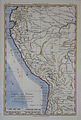
- 1814- Cartógrafo : J. Mall (casi ilegible). Nombre del mapa : South America. Drawn and engraved for Thomson’s New General Atlas. Fecha : 16 de septiembre de 1814. Lámina número 69.