User:Allice Hunter/UP info
FAQ[edit]
What are the sources of your maps?[edit]
It depends on the type of map we are talking about. They are usually based on sources from international or national organisations, or they can be based on numbers and sources found on Wikipedia.
The data does not match the map sources or the map is incorrect[edit]
In some cases, I can use more than one source and have to choose between the two sources with conflicting data. So the map might not match the source you checked. If the map does not match any of the sources in the file description, it may be really incorrect, because I, Allice, am a person too 😅.
You made a mistake, could you fix the map?[edit]
First, I recommend checking the map sources in the file description. The map may have been based on old or conflicting sources, I may not have found enough sources to include some data, the maps might have been based on numbers taken from Wikipedia that are no longer there (or are on broken/dead URLs), or it might include or exclude data depending on the type of definition used (which may vary by country or region). For example, a map of a diaspora might include people who, by definition in your country or region, would not be part of such an ethnic group, but if the sources I found include them, they will be on the map. Some maps of diasporas may include people with ancestry and citizenship of a country, and even if they were not born there they may be included as part of the diaspora. If you have sources that prove I made a mistake or sources that are more recent than the ones I used, you can fix the map with no problems.
May I edit the maps myself? If so, how can I do that?[edit]
Sure! But don't forget to include formatted sources for your changes in the file description. If you do not include sources, your changes can be reverted. To edit the map I recommend you to use Inkscape and pay attention to the correct colours for the change you want to make. Do not change the colour scheme as this would require editing every Wikipedia page that uses the file with the legend template. If you use another application instead of Inkscape, it is possible that the map loses quality, gets unformatted and presents bugs. To avoid duplication, do not upload a new version as if it were a new file on Commons, instead, upload a new version of the file (the link to upload correctly is just below the file history section).
May I post your maps and use them for other purposes?[edit]
Sure! You don't have to but I ask you to make it clear who created the maps.
Should I update the existing file or upload it as a new file?[edit]
Some files have the year of their data in their name, for example: File:2020 UN Human Development Report.svg and File:European countries by GDP nominal per capita (2020).svg. In such cases, it is recommended to upload the file as a new file using the same filename and extension, changing only the year of the data (and keeping the same colour scheme). For example, the updated map of File:European countries by GDP nominal per capita (2020).svg was uploaded as File:European countries by GDP nominal per capita (2021).svg.
Can you change the cartographic projection of your maps?[edit]
As per BlankMap-World.svg/Documentation I'm supposed to use cylindrical projections, especially Equirectangular projection or Miller cylindrical projection. I particularly prefer the Miller projection, as in my opinion it doesn't compress the Northern Hemisphere so much. If the Robinson projection is used nevertheless, the map must retain the Earth's elliptical outline to make it clear that it's Robinson and not one of the cylindrical projections. Some of my maps might be using Robinson projection without retaining the Earth's elliptical outline because those maps were made before I knew about these conventions.
Why haven't you created map X yet?[edit]
Maybe I have! You can check this Category:Maps of ethnic groups by Allice Hunter to be sure. If I haven't created it yet, there are some explanations. For me, creating a map relies heavily on the availability of sources. In many cases, I'm not able to find enough up-to-date sources and this is one of the explanations why a map has not been made yet. Another reason could be that I haven't thought about creating such a map yet, or it's not high on my priority list. Anyway, you can ask for a specific map on my talk page, and then I'll see if I can find sources to create it.
Some contributions[edit]
Diaspora maps[edit]
See Category:Maps of ethnic groups by Allice Hunter
-
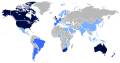
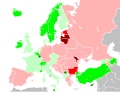
 African diaspora
 -
 Arab diaspora
 -
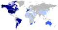
 British diaspora
 -
 Chinese diaspora
 -
 French diaspora
 -
 German diaspora
 -
 Indian diaspora
 -
 Italian diaspora
 -
 Japanese diaspora
 -
 Portuguese diaspora
 -
 Russian diaspora
 -
 Spanish diaspora


World maps[edit]
See Category:HDI maps of the world, Category:GDP maps of the world and Category:World maps of malnutrition
-
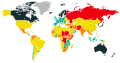
 World HDI map according to the United Nations in 2017
 -
 World HDI map according to the United Nations in 2018
 -
 World HDI map according to the United Nations in 2019
 -
 World HDI map according to the United Nations in 2021
 -
 World HDI map according to the United Nations in 2021 divided into scores of 0.050
 -
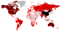
 World GDP nominal per capita map according to the IMF in 2021
 -
 World GDP PPP per capita map according to the IMF in 2021
 -
 World English proficiency map according to EF in 2021
 -
 Map of the GINI index in the world from 1990 to 2020
 -
 Map of the suicide rate in the world according to the WHO in 2019
 -
 Map of the intentional homicide rate in the world from 2006 to 2018
 -
 Map of the Global Peace Index in the world as of 2021
 -
 Map of the Global Peace Index in the world as of 2022
 -
 Map of the Corruption Perceptions Index in the world as of 2021
 -
 Hunger Map 2020 according to the World Food Programme
 -
 Hunger Map 2021 according to the World Food Programme


.svg)
_per_capita_in_2021.svg)
_per_capita_in_2021.svg)
.svg)
.svg)
.svg)
.svg)
.svg)
.svg)
.svg)


Maps of Europe[edit]
See Category:GDP maps of Europe and Category:HDI location maps
-
 Europe HDI map according to the United Nations in 2019
 -
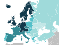
 Europe GDP nominal map according to the International Monetary Fund and the World Bank in 2020
 -
 Europe GDP nominal per capita map according to the International Monetary Fund and the World Bank in 2020
 -
 Europe GDP nominal per capita map according to the International Monetary Fund and the World Bank in 2021
 -
 Europe population map according to national statistics
 -
 Life expectancy in Europe in 2020 according to the Wolrd Bank
 -
 Population growth in Europe in 2021 according to the CIA World Factbook
.svg)
.svg)
.svg)
.svg)
.svg)
.svg)
.svg)
Portugal location maps[edit]
See Category:SVG maps of Portugal
-
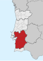 Alentejo region in Portugal
 -
 Algarve region in Portugal
 -
 Central region in Portugal
 -
 Lisbon metropolitan region in Portugal
 -
 Northern region in Portugal


HDI maps at the subnational level[edit]
See Category:HDI maps of subnational entities
-
 HDI map of Chinese administrative divisions in 2019
 -
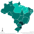 HDI map of Brazilian states in 2017
 -
 HDI map of Canadian provinces and territories in 2019
 -
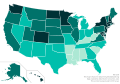 HDI map of the U.S. states in 2018
 -
 HDI map of Argentinian provinces in 2016
.svg)
.svg)
.svg)
.svg)
-
 HDI map of Australian states in 2017
 -
 HDI map of Austrian states in 2017
 -
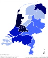 HDI map of Dutch provinces in 2017
 -
 HDI map of Russian federal subjects in 2016
 -
 HDI map of German states in 2018
 -
 HDI map of Indian states and territories in 2017
 -
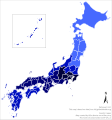 HDI map of Japanese prefectures in 2017
 -
 HDI map of Danish regions in 2017
 -
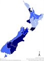 HDI map of New Zealander regions in 2017
 -
 HDI map of Norwegian regions in 2017
 -
 HDI map of Swiss regions in 2018
 -
 HDI map of British regions in 2017
.svg)
.svg)
.svg)
.svg)
.svg)
.svg)
.svg)
.svg)
.svg)
.svg)
.svg)
.svg)
Köppen climate maps of Brazil and Argentina[edit]
See Category:Köppen climate classification maps of states of Brazil and Category:Köppen climate classification maps of provinces of Argentina
Brazil[edit]
-
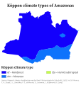 Köppen climate map of Amazonas
 -
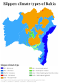 Köppen climate map of Bahia
 -
 Köppen climate map of Minas Gerais
 -
 Köppen climate map of Roraima
 -
 Köppen climate map of Paraná
 -
 Köppen climate map of Mato Grosso do Sul
 -
 Köppen climate map of São Paulo
 -
 Köppen climate map of Rio de Janeiro
 -
 Köppen climate map of Pernambuco
 -
 Köppen climate map of Ceará
 -
 Köppen climate map of Santa Catarina
 -
 Köppen climate map of Rio Grande do Sul


Argentina[edit]
-
 Köppen climate map of Buenos Aires
 -
 Köppen climate map of Catamarca
 -
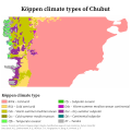 Köppen climate map of Chubut
 -
 Köppen climate map of Córdoba
 -
 Köppen climate map of Jujuy
 -
 Köppen climate map of La Pampa
 -
 Köppen climate map of Mendoza
 -
 Köppen climate map of Neuquén
 -
 Köppen climate map of Salta Köppen
 -
 Köppen climate map of San Juan
 -
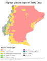 Köppen climate map of Santa Cruz
 -
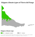 Köppen climate map of Tierra del Fuego


Photo montages[edit]
-
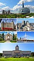
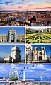 Lisbon photo montage
 -
 Campos do Jordão photo montage
 -
 Londrina photo montage
 -
 Maringá photo montage
 -
 Pomerode photo montage
 -
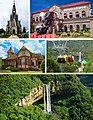 Canela photo montage
 -
 Holambra photo montage
 -
 Olinda photo montage
 -
 Macapá photo montage
 -
 Boa Vista photo montage
 -
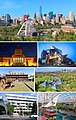
 Toronto photo montage
 -
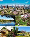
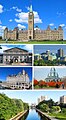 Ottawa photo montage
 -
 Winnipeg photo montage
 -
 Edmonton photo montage
 -
 Victoria photo montage
 -
 Vancouver photo montage
 -
 Calgary photo montage
 -
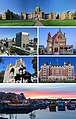
 Montreal photo montage
 -
 Regina photo montage
 -
 Saskatoon photo montage


.jpg)


Barnstars[edit]

|
Imagens |
| Olá, Alice! Vi que você criou as imagens das regiões geográficas imediatas de SP. Parabéns pelo seu trabalho. Você fará as imagens dos outros estados? Estou criando páginas para as regiões de MG. Oalvinegro (talk) 00:14, 17 September 2018 (UTC) |

|
The Original Barnstar |
| Your montage at Toronto is fabulous. Magnolia677 (talk) 14:36, 13 June 2020 (UTC) |

|
The Graphic Designer's Barnstar |
| For your work creating maps, which I have come across countless times on different articles! Keep up the AMAZING work! B. M. L. Peters (talk) 01:38, 6 March 2021 (UTC) |

|
Bangladesh Barnstar | |
| For your swift response and delivery of a Bangladeshi diaspora map; a map that will most likely go on to be used across the internet for many years to come. SalamAlayka (talk) 17:32, 25 November 2021 (UTC) |
|
|
The Original Barnstar |
| Hi Allice,
Great job ! Nevertheless I notice a little mistake (or maybe it isn't) on your Anglosphere Map : you colored in blue Martinique which is a french country where mostly french is spoken. Bye! Green Red Black (talk) 10:19, 26 April 2022 (UTC) |