User:Bennylin/Maps
Jump to navigation
Jump to search

-
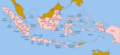
 Indonesia
 -
 Jawa
Jawa -
 Jawa Tengah
 -
 Surakarta
 -
 Sejarah provinsi Indonesia 1945-sekarang


The plan for all svg maps of Indonesia, from subdivision level 1 (province), 2 (city/regency), 3 (district/kecamatan), and possibly 4 (sub-district/village)
All Indonesia[edit]
Category:SVG maps of Indonesia
Blank maps, transparant sea[edit]
-
 Indonesia Blankmap - LV 0 only island outlines
 -
 Indonesian provinces blank - with LV 1 division
 -
 Indonesia provinces outline map - with LV 1 division
 -
 Indonesian cities and regencies - with LV 2 division
 -
Indonesian cities and regencies - with LV 2 division, with land borders (Malaysia and East Timor)
Blank maps, with sea[edit]
-
 Indonesia blank map - LV 0 only island outlines
 -
 Indonesia provinces blank map - with LV 0 only island outlines
 -
 Indonesia location map - with LV 1 division


Colored maps[edit]
-
Indonesia blank map - LV 0 only island outlines
-
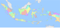 Indonesia blank map colored - with LV 1 division
 -
-
-
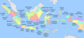
 Geographical units of Indonesia - with LV 0.5 division (main island groupings)
 -
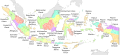
 Electoral Districts Indonesia DPR 2019 - with LV 1.5 division (sub-province groupings)
 -
 Maritime South East Asia


Maps with label[edit]
All Indonesia[edit]
-

-
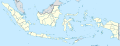
 Indonesia, administrative divisions - en - monochrome
 -
-
Indonesia, administrative divisions - id - colored
-
-
Indonesia blank map colored - with LV 1 division
-
-
 The World Turned Upside Down (sculpture by Mark Wallinger)


Subdivisions[edit]
-
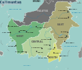 Kalimantan

Locator maps[edit]
Category:SVG locator maps of Indonesia (location map scheme) Category:Location maps of Indonesia
-
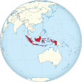
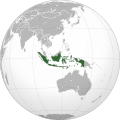 Indonesia (orthographic projection)
 -
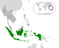
 Indonesia in the World
 -
 Indonesia in the world (W3)
.svg)

.svg)
-
 Indonesia on the globe (Asia centered)
 -
 Indonesia in Asia
.svg)

-
 Indonesia on the globe (Oceania centered)
 -
 Indonesia in Oceania
.svg)

-
 Indonesia on the globe (Southeast Asia centered)
 -
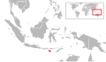
 Location Indonesia ASEAN
.svg)

-
 Indonesia on the globe (Indonesia centered)
 -
 Indonesia in its region
 -
 LocationIndonesia
.svg)


LV 0.5 - island/island groupings maps[edit]
Sumatra maps[edit]
-
 Sumatra blank map
 -
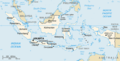
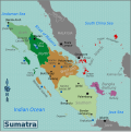 Sumatra regions map


-

-
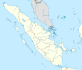 Indonesia Sumatra location map
 -
 LocationSumatra.svg


Java maps[edit]
-
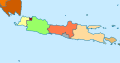
 Java blank map
-
-

-
-

-
 Indonesia Java location map


Kalimantan maps[edit]
-
 Borneo blank map
 -
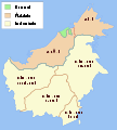 Administrative map of Borneo
 -
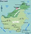 Borneo map


-
-

-
 Indonesia Kalimantan location map
 -
 LocationBorneo


Lesser Sunda Islands (Nusa Tenggara) maps[edit]
-
 Lesser sunda islands blank map
-
 Indonesia Lesser Sunda Islands location map
 -
 LocationLesserSundaIslands (Nusa Tenggara)


Sulawesi maps[edit]
-
 Sulawesi blank map inc islands
 -
 Sulawesi blank map
 -
 Sulawesi Regions map


-

-
 Indonesia Sulawesi location map
 -
 LocationSulawesi


Moluccas & Papua Indonesia maps[edit]
-
-
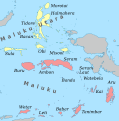
 Indonesia Maluku-Western New Guinea adm location map
 -
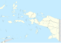
 Indonesia Maluku-Western New Guinea location map


-
 Indonesia Maluku location map
 -
 Indonesia North Maluku location map


-
 Indonesia Papua location map
 -
 Indonesia West Papua location map
 -
 LocationWestPapua - TODO REDO


Individual islands: Category:Locator maps of islands of Indonesia
-
 Flores Locator
 -
 Sumba Locator
 -
 Sumbawa Locator
 -
 Halmahera Locator
 -
 Seram Locator


LV 1 - province maps[edit]
Main gallery: [[Province]].
Category:SVG locator maps of provinces in Indonesia (location map scheme)
LV 1.5 - electoral units[edit]
For articles like id:Sulawesi_Barat_(daerah_pemilihan)
LV 2 - city/regency maps[edit]
Main gallery: [[Regencity]].
See also[edit]
- Maps are also available as part of the
 Wikimedia Atlas of the World project in the Atlas of Indonesia.
-
 Blank map of Indonesia
 -
Indonesia and her neighbours
-
Locator map of Indonesia
-
 Map of Indonesia
 -
 Maps of Indonesian archipelagic baselines pursuant to article 47, paragraph 9, of the United Nations Convention on the Law of the Sea


External links[edit]
- Digital Atlas of Indonesian History by Robert Cribb from 17th century and earlier