Atlas of North America

From Wikimedia Commons, the free media repository
Jump to navigation Jump to search
Wikimedia Commons Atlas of the World

The Wikimedia Atlas of the World is an organized and commented collection of geographical, political and historical maps available at Wikimedia Commons.
Discussion • Update the atlas • Index of the Atlas • Atlas in categories • Other atlases on line
The introductions of the country, dependency and region entries are in the native languages and in English. The other introductions are in English.


Atlas of North America
North America
English North America
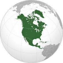
North America is a continent in the Earth's northern hemisphere and almost fully in the western hemisphere. It is bordered on the north by the Arctic Ocean, on the east by the North Atlantic Ocean, on the southeast by the Caribbean Sea, and on the south and west by the North Pacific Ocean; South America lies to the southeast, connected to North America by the isthmus of Panama. It covers an area of about 24,490,000 km² (9,450,000 sq mi), or about 4.8% of the planet's surface. As of October 2006, its population was estimated at over 514,600,000. It is the third-largest continent in area, after Asia and Africa, and is fourth in population after Asia, Africa, and Europe. Central America is the central geographic region of the Americas. It is variably defined either as being a region of the Americas in its own right or as the southern portion of North America. The Caribbean is a region of the Americas consisting of the Caribbean Sea, its islands (most of which enclose the sea), and the surrounding coasts. The region is located southeast of Northern America, east of Central America, and to the north and west of South America.
Español América del Norte es un subcontinente que forma parte de América, situado en el hemisferio norte, y casi por completo en el hemisferio occidental. Limita al norte con el Océano Glacial Ártico, al este con el Océano Atlántico, al sureste con el Mar Caribe y al sur y al oeste con el Océano Pacífico. Al sureste está unido con Centroamérica por el istmo de Tehuantepec.
Français L’Amérique du Nord est un continent ou la partie nord de l’Amérique, selon le point de vue. Elle se positionne à l’est de l’océan Pacifique, à l’ouest de l’océan Atlantique, au sud de l’océan Arctique et au nord de l’Amérique du Sud.
Population 514,600,000 inhabitants
Area 24,490,000 km²
Major language(s) English, Spanish, French
Major religion(s) Roman Catholicism and Protestantism
More information North America, Geography of North America, History of North America and Politics of North America
More images North America - North America (Category).

General maps

Location of the Americas
Map of the Americas
Mapa de América
Carte de l'Amérique
Map of the Americas
Mapa de América
Carte de l'Amérique

North America

Relief map of North America with labels
Relief map of North America (unlabeled)
Blank map of North America
Political map with 1st level divisions in SVG format
North America bedrock and terrain
North American cratons and basement rocks
North American craton
Sedimentary rock map
volcanic rock map
plutonic rock map
metamorphic rock map
Map of Central America
Blank map of Central America
Caribbean by political system:
 
Independent Republics
 
Independent Commonwealth Realms
 
Independent Commonwealth republics
 
French overseas departments and overseas regions (integrated), French overseas collectivity (dependencies)
 
Parts of the Kingdom of the Netherlands (dependencies)
 
United States insular areas (dependencies)
The four NERC Interconnections, and the eight NERC Regional Reliability Organizations.

History maps

This section holds a short summary of the history of the area of present-day North America, illustrated with maps, including historical maps of former countries and empires that included present-day North America.

Voyages of Christoper Columbus
Colonization of the Americas
Spanish colonization
History of North America 1750-1999

Images

Old maps

This section holds copies of original general maps more than 70 years old.

Map showing Vinland
First map to show the name America
Piri Reis map
Map of the Americas 1587 (Ortelius)
Map of the Americas 1637 (Hondius)
Map of North America 1681
Map of the Americas 1705
Map of the Americas 1722
Map of the Americas 1770
North America 1797
Map of Central America and the Caribbean,
North America 1885
Central America 1892
North America 1914

Maps of international organizations

Organization of American States
Rio Group
Caribbean Community and Common Market
Organisation of Eastern Caribbean States
North Atlantic Treaty Organisation
NATO versus Warsaw Pact 1949-1960
NATO Partners
Organization for Security and Co-operation in Europe
Arctic Council
Asia-Pacific Economic Cooperation

Ethnic maps

Native languages of North America
Indian population of the Americas

Satellite maps

Satellite map

Notes and references

General remarks:

  • The WIKIMEDIA COMMONS Atlas of the World is an organized and commented collection of geographical, political and historical maps available at Wikimedia Commons. The main page is therefore the portal to maps and cartography on Wikimedia. That page contains links to entries by country, continent and by topic as well as general notes and references.
  • Every entry has an introduction section in English. If other languages are native and/or official in an entity, introductions in other languages are added in separate sections. The text of the introduction(s) is based on the content of the Wikipedia encyclopedia. For sources of the introduction see therefore the Wikipedia entries linked to. The same goes for the texts in the history sections.
  • Historical maps are included in the continent, country and dependency entries.
  • The status of various entities is disputed. See the content for the entities concerned.
  • The maps of former countries that are more or less continued by a present-day country or had a territory included in only one or two countries are included in the atlas of the present-day country. For example the Ottoman Empire can be found in the Atlas of Turkey.

Entries available in the atlas

General pages
World
Continents and oceans
Themes
Historical eras
States with wide recognition
States with limited recognition
Dependencies and other overseas territories
Country subdivisions
Belgium
China (mainland)
India
Pakistan
Spain
United Kingdom
United States
Other
Disputed subnational territories
Other regions
Cities
Former sovereign states
Former dependencies and overseas territories
Former disputed territories