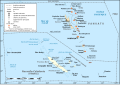
The Republic of Vanuatu is a Melanesian island nation located in the South Pacific Ocean. The archipelago is located some 1,750 km (1090 mi) east of ► Australia, 500 km (310 mi) north-east of ► New Caledonia, west of ► Fiji and south of the ► Solomon Islands. Vanuatu was first inhabited by Melanesian people. Europeans began to settle in the area in the late 18th century and in 1906 Britain and France officially claimed the country, jointly managing it through the British-French Condominium. An independence movement was established in the 1970s, and the Republic of Vanuatu was created in 1980.
La République du Vanuatu est un État de Mélanésie situé dans le sud-ouest de l'océan Pacifique, en mer de Corail. L'archipel est situé à 1 750 kilomètres à l'est de l'Australie, au nord-est de la Nouvelle-Calédonie, à l'ouest des îles Fidji et au sud des îles Salomon.
Short name
Vanuatu
Official name
Republic of Vanuatu
Status
Independent country since 1980
Location
Pacific Ocean
Capital
Port-Vila
Population
272,459 inhabitants
Area
12,189 square kilometres (4,706 sq mi)
Major languages
Bislama, English and French (all official)
Major religions
Protestantism, Roman Catholicism, and Indigenous Beliefs
This section holds maps of the administrative divisions.
Regional maps
Espiritu Santo
Efate
Malakula
Torres Islands
Banks Islands
Torres & Banks Islands
Toponymic map of Torres Is
Toponymic map of Hiw (Torres Is)
Satellite maps
Satellite map
Notes and references
General remarks:
The WIKIMEDIA COMMONS Atlas of the World is an organized and commented collection of geographical, political and historical maps available at Wikimedia Commons. The main page is therefore the portal to maps and cartography on Wikimedia. That page contains links to entries by country, continent and by topic as well as general notes and references.
Every entry has an introduction section in English. If other languages are native and/or official in an entity, introductions in other languages are added in separate sections. The text of the introduction(s) is based on the content of the Wikipedia encyclopedia. For sources of the introduction see therefore the Wikipedia entries linked to. The same goes for the texts in the history sections.
Historical maps are included in the continent, country and dependency entries.
The status of various entities is disputed. See the content for the entities concerned.
The maps of former countries that are more or less continued by a present-day country or had a territory included in only one or two countries are included in the atlas of the present-day country. For example the Ottoman Empire can be found in the Atlas of Turkey.


 Map of New Caledonia and Vanuatu
 Map of New Caledonia and Vanuatu


 Espiritu Santo
 Efate
Efate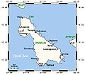 Malakula
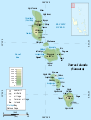 Torres Islands
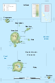 Banks Islands
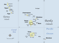 Torres & Banks Islands
 Toponymic map of Torres Is
 Toponymic map of Hiw (Torres Is)


