Category:Blüemlisalp
Jump to navigation
Jump to search
Deutsch: Blüemlisalp
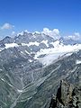
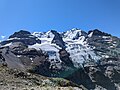
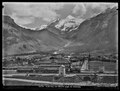
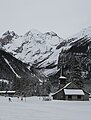
English: Blüemlisalp (Blümlisalp) is a massif of the Bernese Alps, in the territory of the municipalies of Kandersteg and Reichenbach im Kandertal.
massif of the Bernese Alps   | |||||
| Upload media | |||||
| Instance of | |||||
|---|---|---|---|---|---|
| Location | Bern, Switzerland | ||||
| Mountain range |
| ||||
| Topographic prominence |
| ||||
| Topographic isolation |
| ||||
| Elevation above sea level |
| ||||
| Parent peak | |||||
 | |||||
Subcategories
This category has the following 11 subcategories, out of 11 total.
B
- Blüemlisalp Glacier (37 F)
- Blüemlisalp Rothorn (1 P, 22 F)
- Blüemlisalphütte (18 F)
H
M
- Morgenhorn (25 F)
O
- Oeschinenhorn (14 F)
P
U
- Ufem Stock (Bernese Alps) (15 F)
W
- Wyssi Frau (27 F)
Media in category "Blüemlisalp"
The following 127 files are in this category, out of 127 total.
-
 1248 Mürren.jpg 14,000 × 9,600; 134.85 MB
-
 1578-Oeschinensee.jpg 4,240 × 2,832; 5.27 MB
-
 1588-Oeschinensee.jpg 4,240 × 2,832; 7.29 MB
-
 2013-03-16 13-33-58 Switzerland Kanton Bern Thun Thun.JPG 3,200 × 2,125; 3.26 MB
-
 20190725 Aufstieg Oeschinensee mit Blüemlisalp, Kandersteg (06452).jpg 3,763 × 5,644; 18.84 MB
-
 20190725 Oeschinensee-Panorama, Kandersteg (06540-42 stitch).jpg 9,603 × 5,138; 28.09 MB
-
 Alps flowers.jpg 3,024 × 4,032; 2.29 MB
-
 Beck-Wyssi Frau.jpg 595 × 420; 65 KB
-
 Berghotel Oeschinensee.jpg 4,000 × 2,667; 850 KB
-
 Bergsee Oeschinen.jpg 5,104 × 3,387; 12.12 MB
-
 Bern (6166049065).jpg 4,608 × 3,072; 4.88 MB
-
 Bluem from north side.jpg 3,264 × 2,448; 2.74 MB
-
 Bluemlisalp-sued.jpg 480 × 640; 96 KB
-
 Bluemlisalp.jpg 568 × 298; 53 KB
-
 Blüemlisalp 1 from north.jpg 2,448 × 3,264; 2.22 MB
-
 Blüemlisalp 2 from north.jpg 3,264 × 2,448; 2.35 MB
-
 Blüemlisalp mountain range with clouds.jpg 5,760 × 3,840; 6.88 MB
-
 Blüemlisalp mountainrange at Oeschiland.jpg 5,760 × 3,840; 8.29 MB
-
 Blüemlisalp Oeschinensee.jpg 5,184 × 3,888; 4.22 MB
-
 Blüemlisalp Rothorn.jpg 4,080 × 3,072; 4.28 MB
-
 Blüemlisalp v Laegern 160717.jpg 5,472 × 3,648; 3.11 MB
-
 Blüemlisalp Winter.jpg 3,968 × 2,232; 3.2 MB
-
 Blüemlisalp-Morgehorn and mountain Wildi Frau.jpg 1,210 × 1,613; 509 KB
-
 Blüemlisalp.png 740 × 565; 603 KB
-
 Blüemlisalpgletscher 2.jpg 4,080 × 3,072; 3.36 MB
-
 Blüemlisalpgletscher.jpg 2,592 × 1,944; 1.33 MB
-
 Blüemlisalphorn.jpg 4,722 × 3,686; 4.2 MB
-
 Blümlisalp (Paul Mirabaud, 1890).jpg 1,812 × 1,336; 450 KB
-
 Blümlisalp 2005-03-25.jpg 1,051 × 591; 158 KB
-
 Blümlisalp and chalets, Bernese Oberland, Switzerland-LCCN2001701292.jpg 3,598 × 2,680; 2.99 MB
-
 Blümlisalp.jpg 1,200 × 900; 381 KB
-
 Bundstock.jpg 3,072 × 4,080; 4.82 MB
-
 Castle of Thun in front of mountain.jpg 2,717 × 1,829; 516 KB
-
 CH-NB Photoglob-Wehrli EAD-WEHR-24724-B.tif 7,413 × 5,597, 2 pages; 79.2 MB
-
 CH-NB Photoglob-Wehrli EAD-WEHR-32088-B.tiff 4,546 × 3,321; 14.43 MB
-
 CH-NB-Luzern, Pilatus, Brünig-Route-19122-page021.tif 1,112 × 735; 963 KB
-
 CH-NB-Souvenir de la Suisse-19304-page004.tif 4,704 × 1,753; 20.08 MB
-
 CH-NB-Souvenir de la Suisse-19304-page033.tif 4,709 × 1,771; 16.05 MB
-
 CH-NB-Souvenir de la Suisse-19304-page037.tif 2,259 × 1,733; 8.12 MB
-
 CH-NB-Souvenir de la Suisse-19304-page069.tif 4,644 × 1,768; 18.29 MB
-
 Cross-country skiing at the Marienkirche in Kandersteg.jpg 3,655 × 4,809; 2.95 MB
-
 Die Gartenlaube (1896) b 0377.jpg 2,428 × 3,404; 2.5 MB
-
 ETH-BIB-Blüemlisalp von Nord-Ost-LBS H1-022228.tif 6,174 × 4,319; 76.33 MB
-
 ETH-BIB-Blüemlisalp, Bietschhorn, Walliseralpen v. N. aus 5000 m-Inlandflüge-LBS MH01-001251.tif 6,210 × 4,553; 81.08 MB
-
 ETH-BIB-Blüemlisalp, Doldenhorn, Balmhorn, Walliseralpen-Inlandflüge-LBS MH01-001242.tif 6,607 × 4,552; 86.17 MB
-

-

-
-

-
 ETH-BIB-Blüemlisalp-Inlandflüge-LBS MH01-007701.tif 5,495 × 3,805; 59.93 MB
-
 ETH-BIB-Blüemlisalp-LBS H1-022226.tif 6,160 × 4,324; 76.24 MB
-
 ETH-BIB-Blüemlisalp-LBS H1-022227.tif 6,173 × 4,306; 76.09 MB
-
 ETH-BIB-Blüemlisalphorn, Doldenhorn, Balmhorn-Inlandflüge-LBS MH05-17-02.tif 3,508 × 2,295; 23.13 MB
-

-
 ETH-BIB-Blümlisalp mit Wolken, Oeschinensee v. W. aus 3600 m-Inlandflüge-LBS MH01-000446.tif 6,656 × 4,486; 85.58 MB
-
 ETH-BIB-Blümlisalp Sefinenfurke-LBS H1-025767.tif 6,621 × 4,675; 88.59 MB
-
 ETH-BIB-Blümlisalp v. Nordern-LBS H1-020588.tif 5,974 × 4,755; 81.36 MB
-
 ETH-BIB-Blümlisalp v. Nordern-LBS H1-020589.tif 5,972 × 4,717; 80.69 MB
-
 ETH-BIB-Blümlisalp, Oeschinensee v. W. aus 4000 m-Inlandflüge-LBS MH01-000448.tif 6,672 × 4,671; 89.32 MB
-
 ETH-BIB-Blümlisalp, vom südlichen Emdtal bei Heustrich-Dia 247-12699.tif 3,646 × 2,798; 29.31 MB
-
 ETH-BIB-Blümlisalphorn, Kanderfirn v. S. aus 4000 m-Inlandflüge-LBS MH01-000455.tif 6,646 × 4,570; 87.05 MB
-

-

-

-
 ETH-BIB-Brisen, v. N.-LBS H1-011305.tif 6,116 × 4,213; 73.93 MB
-

-
 ETH-BIB-Gamichlücke, Büemlisalp, Bietschhorn-Inlandflüge-LBS MH01-001248.tif 6,237 × 4,425; 79.13 MB
-
 ETH-BIB-Gspaltenhorn, Blüemlisalp, Kanderfirn, Balmhorn-Inlandflüge-LBS MH05-17-04.tif 3,508 × 2,304; 23.22 MB
-
 ETH-BIB-Gspaltenhorn, Blümlisalphorn, Balmhorn-Inlandflüge-LBS MH05-17-03.tif 3,508 × 2,304; 23.22 MB
-

-

-

-
 ETH-BIB-Kiental, Blüemlisalp-LBS H1-008823.tif 6,500 × 4,522; 84.22 MB
-
 ETH-BIB-Morgenhorn, Wyssi Frau, Blüemlisalphorn, Bietschhorn-Inlandflüge-LBS MH05-15-08.tif 3,508 × 2,293; 23.12 MB
-
 ETH-BIB-Morgenhorn, Wyssi Frau, Blüemlisalphorn-Inlandflüge-LBS MH05-15-02.tif 3,508 × 2,456; 24.76 MB
-
 ETH-BIB-Morgenhorn, Wyssi Frau, Blüemlisalphorn-Inlandflüge-LBS MH05-17-01.tif 3,508 × 2,346; 23.65 MB
-
 ETH-BIB-Oeschinensee Blümlisalp-Dia 247-05469.tif 2,951 × 3,507; 29.7 MB
-
 ETH-BIB-Oeschinensee, Blüemlisalp-LBS H1-008820.tif 6,401 × 4,362; 26.8 MB
-
 ETH-BIB-Oeschinensee, Blüemlisalpgruppe v. W. aus 3200 m-Inlandflüge-LBS MH01-005746.tif 4,434 × 6,550; 83.19 MB
-

-

-

-
 ETH-BIB-Weisse Frau, Grat-Gwächte-Dia 247-F-00666.tif 3,582 × 2,722; 9.4 MB
-

-
 Ferdinand Hodler - Thunersee mit Blüemlisalp und Niesen.jpg 5,623 × 3,914; 2.33 MB
-
 Fründenhütte vom See.jpg 900 × 675; 151 KB
-
 Hengsterengletscher Hornseewli Panorama 20220612.jpg 10,250 × 3,758; 11.51 MB
-
 Hodler - Kiental mit Blümlisalp - 1902.jpeg 4,680 × 4,620; 13.46 MB
-
 Hohtürli Pass.jpg 4,080 × 3,072; 6.09 MB
-
 Kandersteg Valley.jpg 5,184 × 3,038; 10.97 MB
-

-
 Kandersteg, Hotel Victoria and Blumlisalp, Bernese Oberland, Switzerland-LCCN2001701208.jpg 3,666 × 2,728; 3.14 MB
-
 Kandertal, Oeschinensee.jpg 4,160 × 3,120; 8.22 MB
-
 Kiental 2022.JPG 2,511 × 2,383; 1.69 MB
-
 Kienthal and Alpine hut, Bernese Oberland, Switzerland-LCCN2001701209.jpg 3,692 × 2,747; 3.1 MB
-
 Lake Oeschennen. Near Kanderstegg LCCN94514020.jpg 3,278 × 4,096; 1.98 MB
-
 Lake Oeschennen. Near Kanderstegg LCCN94514020.tif 3,278 × 4,096; 12.81 MB
-
 Lake Oeschinen, Kandersteg, Switzerland - panoramio (2).jpg 4,000 × 3,000; 2.7 MB
-
 Lutschinen, Oeschinensee, Bernese Oberland, Switzerland-LCCN2001701221.jpg 3,703 × 2,767; 2.93 MB
-
 Max Buri Blick auf die Blümlisalp.jpg 1,999 × 1,377; 1.31 MB
-
 Morning Rise in Lake Oeschinensee.jpg 5,472 × 3,648; 6.1 MB
-
 Mutthorn Steinmann.jpg 4,032 × 2,268; 4.17 MB
-
 My swisster from another mister.jpg 1,620 × 1,942; 1.29 MB
-
 Niederhorn vom Norden vor Blüemlisalp und Gspaltenhorn.jpg 830 × 466; 80 KB
-
 Niesen7.jpg 567 × 377; 232 KB
-
 OES 06.jpg 1,824 × 1,368; 661 KB
-
 Oeschinen Lake (Oeschinensee) panorama from above 140622.jpg 8,192 × 3,320; 13.54 MB
-
 Oeschinen.jpg 1,000 × 667; 139 KB
-
 Oeschinenbach des de Kandersteg, amb Blüemlisalp al fons.jpg 549 × 768; 67 KB
-
 Oeschinenbach, vista del Blüemlisalp al fons.jpg 544 × 768; 75 KB
-
 Oeschinenesee - panoramio.jpg 1,024 × 768; 908 KB
-
 Oeschinensee 0437.jpg 3,456 × 2,304; 1.86 MB
-
 Oeschinensee 2022.JPG 4,032 × 3,024; 4.75 MB
-
 Oeschinensee Hund und Gegenlicht.jpg 5,472 × 3,648; 16.37 MB
-
 Oeschinensee in autumn.jpg 3,024 × 4,032; 2.75 MB
-
 Oeschinensee, Switzerland.jpg 4,160 × 2,340; 4.05 MB
-
 Picswiss BE-90-19 Oeschinensee mit Blüemlisalp.jpg 500 × 333; 58 KB
-
 Picswiss BE-90-24 Blüemlisalp.jpg 300 × 450; 38 KB
-
 Pier17.jpg 4,032 × 3,024; 3.39 MB
-
 Rothorn,Blüemlisalphorn,Oeschinenhorn,Fründenhorn.jpg 860 × 645; 128 KB
-
 Spelterini Blüemlisalp 2.jpg 2,107 × 1,530; 1,010 KB
-
 Spelterini Blüemlisalp.jpg 1,806 × 1,341; 996 KB
-
 Switzerland - NARA - 68157219.jpg 5,347 × 6,843; 5.4 MB
-
 The Blüemlisalp (3660m) from the Schilthorn (10955373025).jpg 2,121 × 1,414; 3.01 MB
-
 Thun, castle and Blumlisalp, Bernese Oberland, Switzerland-LCCN2001701260.jpg 3,664 × 2,727; 3.39 MB
-
 Thun, Lake of, Blumlisalp and the Niesen, Bernese Oberland, Switzerland-LCCN2001701252.jpg 3,566 × 2,630; 2.27 MB
-
 View from Schilthorn.JPG 4,320 × 3,240; 4.19 MB


.jpg)
.jpg)


.jpg)


.jpg)


_b_0377.jpg)


.jpg)


_from_the_Schilthorn_(10955373025).jpg)


_panorama_from_above_140622.jpg)