Kandersteg
Jump to navigation
Jump to search
municipality in the canton of Bern in Switzerland     | |||||
| Upload media | |||||
| Instance of | |||||
|---|---|---|---|---|---|
| Location | |||||
| Official language | |||||
| Mountain range | |||||
| Population |
| ||||
| Area |
| ||||
| Elevation above sea level |
| ||||
| official website | |||||
 | |||||
-
 Ansicht von der Allmenalp-Bahn aus, dahinter das Tal zum Oeschinensee
 -
 Der Spycher im Eggenschwand
 -
 Café Schweizerhof
 -
 Reformierte Kirche
 -
 Kandersteg im Winter
 -
 Zentrum
 -
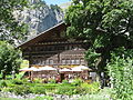
 Gasthof Ruedihaus
 -
 Blick auf Talstation Sunnbüel von der Zufahrt ins Gasterntal
 -
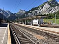 Bahnhof Kandersteg
 -
 A view to mountain Gällihore (left), Loner, Hellhore and Alpschelehubel.


.JPG)
-
 valley Gasteretal, Bernese Alps from above, mountains

Geschichte[edit]
-
 Gasthof Ruedihus von 1753
 -
 Kandersteg, zwischen 1893 und 1924
 -
 Kandersteg Dorf und Blümlisalpgruppe (1890-1900)
 -
 Lötschbergdurchstich 1911,
Lötschberg railway tunnel -
 Fründenhütte (1942)


