<nowiki>Brannenburg; Brannenburg; Brannenburg; Brannenburg; Brannenburg; Brannenburg; Brannenburg; 布拉嫩堡; Brannenburg; Brannenburg; Brannenburg; 布拉嫩堡; Brannenburg; Brannenburg; Brannenburg; Бранненбург; Brannenburg; Brannenburg; Brannaburg; Brannenburg; Brannenburg; Brannenburg; Brannenburg; براننەنبۋرگ; Brannenbwrg; Brannenburg; Браненбург; Brannenburg; Brannenburg; Brannenburg; Бранненбург; Brannenburg; Brannenburg; Brannenburg; Brannenburg; برآنينبورغ; Brannenburg; Brannenburg; 布拉嫩堡; Brannenburg; Brannenburg; Brannenburg; Brannenburg; Brannenburg; Бранненбург; Brannenburg; Brannenburg; Brannenburg; Brannenburg; Brannenburg; Brannenburg; Բրանենբուրգ; 布拉嫩堡; Brannenburg; Branenburg; ブランネンブルク; Brannenburg; Brannenburg; Brannenburg; Brannenburg; ברננבורג; Brannenburg; Brannenburg; Brannenburg; Brannenburg; Brannenburg; Brannenburg; Brannenburg; Brannenburg; Браненбург; Brannenburg; Brannenburg; Brannenburg; Бранненбург; Brannenburg; Brannenburg; Brannenburg; براننبورگ; Brannenburg; Brannenburg; Brannenburg; Brannenburg; Brannenburg; Brannenburg; Brannenburg; Brannenburg; Brannenburg; Brannenburg; Brannenburg; Brannenburg; Brannenburg; Brannenburg; Brannenburg; Brannenburg; Бранненбург; Бранненбург; Brannenburg; Бранненбург; Brannenburg; Brannenburg; Brannenburg; Brannenburg; commune allemande; Gemeinde in Deutschland; komunë në Gjermani; Şaredariyeke Almanyayê; kumun alaman; munisipyo; kota di Jerman; יישוב בגרמניה; gemeente in Beieren; بلدة ألمانية في ولاية بافاريا; település Németországban; громада в Німеччині, федеральна земля Баварія; gmejna w Bayerskej; municipality of Germany; komunumo en Bavario, Germanio; obec v zemském okresu Rosenheim v Německu; kommune i Tyskland; Бранненбург; Brannenburg; Degerndorf am Inn; Brannenburg</nowiki>
part of Landkreis Rosenheim << Oberbayern << Bayern << Germany
Lage
Blick von Antritt auf Brannenburg
Pfarrkirche Mariä Himmelfahrt
Schloss Brannenburg
Wallfahrtskirche Schwarzlack
Untere Treppe hinauf zur Wallfahrtskirche St. Maria Magdalena auf der Biber
Der Wendelstein und das Mangfallgebirge vom Fuße der Biber
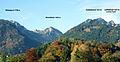
Blick von der Biber Richtung Wendelstein – rechts auf halber Höhe St. Margarethen
Nagelfluhabbau an der Biber – im Hintergrund der gr. Riesenkopf
An einem Abbruchfelsen erkennt man heute noch sichtbare Spuren des Mühlsteinabbaus
OT Sankt Margarethen: Filialkirche Sankt Margaretha
Der Wendelstein von Osten (Brannenburg) aus gesehen
Max Liebermann : Brannenburger Biergarten, 1893
Neue Künstlerkolonie – Streifzüge Kultur: Station 5
This is a gallery page Brannenburg , see Category:Brannenburg


 Lage
Lage Blick von Antritt auf Brannenburg
 Pfarrkirche Mariä Himmelfahrt
 Schloss Brannenburg
 Wallfahrtskirche Schwarzlack
 Untere Treppe hinauf zur Wallfahrtskirche St. Maria Magdalena auf der Biber
 Der Wendelstein und das Mangfallgebirge vom Fuße der Biber
 Blick von der Biber Richtung Wendelstein – rechts auf halber Höhe St. Margarethen
 Nagelfluhabbau an der Biber – im Hintergrund der gr. Riesenkopf
 An einem Abbruchfelsen erkennt man heute noch sichtbare Spuren des Mühlsteinabbaus
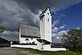 OT Sankt Margarethen: Filialkirche Sankt Margaretha
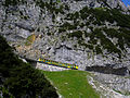

 Der Wendelstein von Osten (Brannenburg) aus gesehen
 Max Liebermann: Brannenburger Biergarten, 1893
 Neue Künstlerkolonie – Streifzüge Kultur: Station 5


