Category:'t Roode Hert
Jump to navigation
Jump to search
| Object location | | View all coordinates using: OpenStreetMap |
|---|
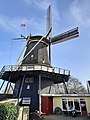
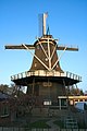
windmill in Alkmaar, Netherlands  | |||||
| Upload media | |||||
| Instance of | |||||
|---|---|---|---|---|---|
| Location | Alkmaar, North Holland, Netherlands | ||||
| Street address |
| ||||
| Located on street |
| ||||
| Has use | |||||
| Heritage designation |
| ||||
| Source of energy | |||||
 | |||||
|
This is a category about rijksmonument number 7467
|
| Address |
|
Media in category "'t Roode Hert"
The following 49 files are in this category, out of 49 total.
-
 't Roode Hert.JPG 3,648 × 2,736; 1.41 MB
-
 't Roode Hert1.JPG 3,648 × 2,736; 1.63 MB
-
 20210220 draaiend binnenwerk Roode Hert.jpg 800 × 600; 138 KB
-
 20210220 Molen en Winkel Roode Hert.jpg 600 × 800; 122 KB
-

-
 Alkmaar, molen4 foto2 2009-04-05 14.52.JPG 3,072 × 2,304; 2.03 MB
-
 Arie Berkhout in actie op de steen van De Hoop te Wervershoof 1977 foto A Peereboom.jpg 1,812 × 1,862; 1.63 MB
-
 Arie Berkhout trekt de kleppen open 1974.jpg 2,674 × 1,875; 2.77 MB
-

-

-

-

-

-
 Gebroken roede roode hert.jpg 639 × 357; 42 KB
-

-

-

-
 Int "t' roode hert - Anton Sipman.jpg 1,657 × 2,329; 1.93 MB
-
 Korenmolen ´t Roode Hert - panoramio.jpg 2,736 × 3,648; 3.12 MB
-
 Molen 't Roode Her 1950.jpg 1,135 × 1,668; 966 KB
-
 Molen 't Roode Her 1975 - Arie Berkhout.jpg 900 × 1,385; 771 KB
-
 Molen 't Roode Hert 01.jpg 1,361 × 1,022; 886 KB
-
 Molen 't Roode Hert 02.jpg 2,838 × 4,066; 8.18 MB
-
 Molen 't Roode Hert 03.jpg 1,003 × 1,349; 900 KB
-
 Molen 't Roode Hert 04.jpg 979 × 1,576; 754 KB
-
 Molen 't Roode Hert 05.jpg 929 × 1,479; 1,007 KB
-
 Molen 't Roode Hert 06.jpg 2,944 × 1,860; 2.8 MB
-
 Molen 't Roode Hert 07.jpg 1,850 × 2,866; 2.76 MB
-
 Molen 't Roode Hert 09.jpg 1,227 × 1,899; 952 KB
-
 Molen 't Roode Hert 10.jpg 1,862 × 1,280; 1.24 MB
-
 Molen 't Roode Hert 11.jpg 1,921 × 1,369; 1.44 MB
-
 Molen 't Roode Hert 12.jpg 1,612 × 2,579; 1.6 MB
-
 Molen 't Roode Hert 13.jpg 1,952 × 1,281; 1.4 MB
-
 Molen 't Roode Hert 14.jpg 1,641 × 1,044; 789 KB
-
 Molen 't Roode Hert 1949 tijdens het bouwen van de as voor de zelfzwichting.jpg 1,227 × 1,899; 1.11 MB
-
 Molen 't Roode Hert 1967.jpg 1,546 × 2,335; 1.58 MB
-
 Molen 't Roode Hert augustus 1951.jpg 1,319 × 1,937; 1.32 MB
-
 Molen 't Roode Hert oktober 1967.jpg 1,592 × 2,330; 1.51 MB
-
 Molen 't Roode Hert.jpg 1,365 × 1,026; 819 KB
-
 Oudorp molen t Roode Hert.jpg 1,400 × 2,100; 1.72 MB
-
 Overzicht - Alkmaar - 20180450 - RCE.jpg 796 × 1,200; 145 KB
-
 Overzicht - Alkmaar - 20363200 - RCE.jpg 1,200 × 1,196; 242 KB
-
 Overzicht - Alkmaar - 20364406 - RCE.jpg 1,200 × 1,197; 259 KB
-
 Overzicht - Oudorp - 20180444 - RCE.jpg 1,200 × 787; 260 KB
-
 Overzicht met molen - Oudorp - 20180441 - RCE.jpg 1,200 × 812; 310 KB
-

-
 Overzicht van de molen - Alkmaar - 20180445 - RCE.jpg 814 × 1,200; 152 KB
-

-
 Winkel 't roode hert.jpg 327 × 244; 44 KB


_Tussen_ongeveer_de_jaren_1960_-_RAA-DMGA-03041_-_RAA_Elsinga.jpg)


_Tussen_ongeveer_de_jaren_1960_en_1990_hee_-_RAA-DMGA-02285_-_RAA_Elsinga.jpg)
