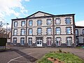
Category:École Jules Ferry de Chappes (Puy-de-Dôme)
Jump to navigation
Jump to search
| Object location | | View all coordinates using: OpenStreetMap |
|---|
Media in category "École Jules Ferry de Chappes (Puy-de-Dôme)"
The following 4 files are in this category, out of 4 total.
-
 Chappes-FR-63-ecole Jules Ferry-a1.jpg 4,032 × 3,024; 5.06 MB
-
 Chappes-FR-63-ecole Jules Ferry-a2.jpg 4,032 × 3,024; 5.03 MB
-
 Chappes-FR-63-ecole Jules Ferry-a3.jpg 4,032 × 3,024; 4.99 MB
-
 Chappes-FR-63-ecole Jules Ferry-a4.jpg 4,032 × 3,024; 4.48 MB


