Category:Église paroissiale Saints-Pierre-et-Paul (Route d'Oron 99, Promasens)
Jump to navigation
Jump to search
| Object location | | View all coordinates using: OpenStreetMap |
|---|
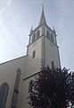
church building in Promasens in the canton of Fribourg, Switzerland  | |||||
| Upload media | |||||
| Instance of | |||||
|---|---|---|---|---|---|
| Part of | |||||
| Location | Promasens, Rue, Glâne District, Canton of Fribourg, Switzerland | ||||
| Street address |
| ||||
| Diocese | |||||
| Heritage designation | |||||
 | |||||
Media in category "Église paroissiale Saints-Pierre-et-Paul (Route d'Oron 99, Promasens)"
This category contains only the following file.
-
 Église de Promasens.JPG 2,263 × 3,263; 1.46 MB