Category:Ófalu (Érd)
Jump to navigation
Jump to search
| Object location | | View all coordinates using: OpenStreetMap |
|---|
city part of Érd | |||||
| Upload media | |||||
| Instance of | |||||
|---|---|---|---|---|---|
| Location | Érd, Érd District, Pest County, Hungary | ||||
 | |||||
Subcategories
This category has the following 15 subcategories, out of 15 total.
B
- Beliczay Island, Érd (7 F)
F
K
- Kastély Street, Érd (5 F)
- Kerék Street, Érd (6 F)
M
- Minaret in Érd (20 F)
- Mély Street, Érd (8 F)
R
S
- Statue of John of Nepomuk in Érd (29 F)
T
- Thermal Liget Hotel (Érd) (6 F)
V
- Votive Chapel in Érd (11 F)
W
- Water pumping station in Érd (3 F)
Media in category "Ófalu (Érd)"
The following 13 files are in this category, out of 13 total.
-
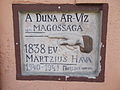 1838 flood level sign. - Mecset street, Érd.JPG 2,272 × 1,704; 977 KB
-
 Brick factory chimney. - Ófalu, Érd.JPG 1,704 × 2,272; 1.03 MB
-
 Danube. View toward south. Western Csepel Island and Sánc hill (Érd). - Hungary.JPG 2,272 × 1,704; 1,016 KB
-
 Irkutsk (tugboat, 1966) and barges from Érd, Hungary.JPG 2,272 × 1,704; 1.02 MB
-
 Irkutsk (tugboat, 1966). - Érd, Hungary.JPG 2,272 × 1,704; 1 MB
-
 Minaret in Érd from south. - Hungary.JPG 1,704 × 2,272; 999 KB
-
 Nagyfeszültségű távvezeték oszlopok. - Érd, Ófalu.JPG 1,704 × 2,272; 992 KB
-
 Steel pylon forest. - Érd, Hungary.JPG 2,272 × 1,704; 990 KB
-
 Sánc (2).jpg 4,000 × 3,000; 3.87 MB
-
 Téglagyári völgy (2).jpg 4,000 × 3,000; 1.46 MB
-
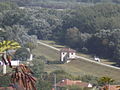 View toward Mecset street's barrage control house. - Érd.JPG 2,272 × 1,704; 1.01 MB
-
 View toward Nagytétény. Listed water tower and silo. - Érd, Hungary.JPG 2,272 × 1,704; 1 MB
-
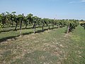 Wineyard. - Kakukk hill, Érd.JPG 2,272 × 1,704; 1,001 KB


._-_Hungary.JPG)
_and_barges_from_%C3%89rd,_Hungary.JPG)
._-_%C3%89rd,_Hungary.JPG)


.jpg)
.jpg)


