Category:Ōtūmahana Estuary
Jump to navigation
Jump to search
estuary in New Zealand  | |||||
| Upload media | |||||
| Instance of | |||||
|---|---|---|---|---|---|
| Location | Buller District, West Coast Region, New Zealand | ||||
| Area |
| ||||
| Mouth of the watercourse |
| ||||
| Outflows |
| ||||
 | |||||
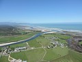
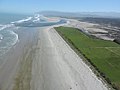
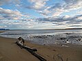
Ōtūmahana Estuary, also known as the Karamea Estuary, is a tidal estuary in the Buller District of the West Coast Region of New Zealand. It is located at the mouth of the Karamea River and also receives the outflow of Granite Creek.
The estuary is the third largest tidal estuary on the West Coast, after Ōkārito Lagoon and Saltwater Lagoon. It has been classified as a Significant Wetland by the West Coast Regional Council in its Regional Land and Water Plan.
Media in category "Ōtūmahana Estuary"
The following 7 files are in this category, out of 7 total.
-
 Karamea River and Ōtūmahana Estuary - MA1.jpg 2,048 × 1,536; 232 KB
-
 Karamea River and Ōtūmahana Estuary.jpg 1,536 × 2,048; 197 KB
-
 Karamea road sign - Slow for bittern.jpg 3,888 × 5,184; 9.48 MB
-
 Outlet from Ōtūmahana Estuary.jpg 2,048 × 1,536; 247 KB
-
 Ōtūmahana Estuary MC 01.jpg 5,184 × 3,888; 8.89 MB
-
 Ōtūmahana Estuary MC 02.jpg 5,184 × 3,888; 7.43 MB
-
 Ōtūmahana Estuary MC3.jpg 5,184 × 3,888; 2.98 MB


