Category:1640s maps of Paris
Jump to navigation
Jump to search
Media in category "1640s maps of Paris"
The following 7 files are in this category, out of 7 total.
-
 1642 map of Ile de France by Willem Janszoon Blaeu.jpg 4,206 × 3,262; 2.74 MB
-
 Carte de l'Isle de France et Brie, ca. 1640 - Open Data Hauts-de-Seine.jpg 6,776 × 5,264; 5.53 MB
-
 Champ de l'Alouette 1648.png 610 × 552; 512 KB
-

-
-

-
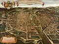
 Lutetia vulgari nomine Paris, urbs Galliae maxima, 1645 by Georg Braun - Gallica.jpg 6,388 × 4,832; 5.69 MB


.jpg)


